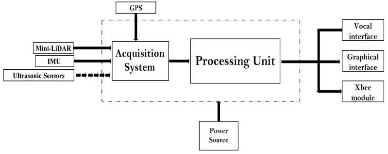
Estimating the state of surrounding vehicles is crucial to either prevent or avoid collisions with other road users. However, due to insufficient historical data and the unpredictability of future driving tactics, estimating the safety status is a difficult undertaking. To address this problem, an intelligent and autonomous traffic management system based on V2V technology is proposed. The main contribution of this work is to design a new system that uses a real-time control system and a fuzzy logic algorithm to estimate safety. The robot operating system (ROS) is the foundation of the control architechture, which connects all the various system nodes and generates the decision in the form of a speech and graphical message. The safe path is determined by a safety evaluation system that combines sensor data with a fuzzy classifier. Moreover, the suitable information processed by each vehicle unit is shared in the group to avoid unexpected problems related to speed, sudden braking, unplanned deviation, street holes, road bumps, and any kind of street issues. The connection is provided through a network based on the ZigBee protocol. The results of vehicle tests show that the proposed method provides a more reliable estimate of safety as compared to other methods.
Citation: Ismail Ben Abdallah, Yassine Bouteraa, Saleh Mobayen, Omar Kahouli, Ali Aloui, Mouldi Ben Amara, Maher JEBALI. Fuzzy logic-based vehicle safety estimation using V2V communications and on-board embedded ROS-based architecture for safe traffic management system in hail city[J]. Electronic Research Archive, 2023, 31(8): 5083-5103. doi: 10.3934/era.2023260
Estimating the state of surrounding vehicles is crucial to either prevent or avoid collisions with other road users. However, due to insufficient historical data and the unpredictability of future driving tactics, estimating the safety status is a difficult undertaking. To address this problem, an intelligent and autonomous traffic management system based on V2V technology is proposed. The main contribution of this work is to design a new system that uses a real-time control system and a fuzzy logic algorithm to estimate safety. The robot operating system (ROS) is the foundation of the control architechture, which connects all the various system nodes and generates the decision in the form of a speech and graphical message. The safe path is determined by a safety evaluation system that combines sensor data with a fuzzy classifier. Moreover, the suitable information processed by each vehicle unit is shared in the group to avoid unexpected problems related to speed, sudden braking, unplanned deviation, street holes, road bumps, and any kind of street issues. The connection is provided through a network based on the ZigBee protocol. The results of vehicle tests show that the proposed method provides a more reliable estimate of safety as compared to other methods.

| [1] |
M. Peden, Global collaboration on road traffic injury prevention, Int. J. Inj. Control Saf. Promot., 12 (2005), 85–91. https://doi.org/10.1080/15660970500086130 doi: 10.1080/15660970500086130

|
| [2] | T. J. C. Sousa, V. Monteiro, J. C. A. Fernandes, C. Couto, A. A. N. Meléndez, J. L. Afonso, New perspectives for vehicle-to-vehicle (V2V) power transfer, in IECON 2018-44th Annual Conference of the IEEE Industrial Electronics Society, IEEE, (2018), 5183–5188. https://doi.org/10.1109/IECON.2018.8591209 |
| [3] | T. Petrov, M. Dado, K. E. Ambrosch, P. Holečko, Experimental topology for V2V communication based on Internet of Things, in 2016 ELEKTRO, IEEE, (2016), 72–76. |
| [4] |
B. M. Masini, A. Bazzi, A. Zanella, A survey on the roadmap to mandate on board connectivity and enable V2V-based vehicular sensor networks, Sensors, 18 (2018), 2207. https://doi.org/10.3390/s18072207 doi: 10.3390/s18072207
|
| [5] |
M. Shurrab, S. Singh, H. Otrok, R. Mizouni, V. Khadkikar, H. Zeineldin, An efficient vehicle-to-vehicle (V2V) energy sharing framework, IEEE Internet Things J., 9 (2021), 5315–5328. https://doi.org/10.1109/JIOT.2021.3109010 doi: 10.1109/JIOT.2021.3109010
|
| [6] |
B. S. Umesh, V. Khadkikar, H. H. Zeineldin, S. Singh, H. Otrok, R. Mizouni, Direct electric vehicle to vehicle (V2V) power transfer using on-board drivetrain and motor windings, IEEE Trans. Ind. Electron., 69 (2021), 10765–10775. https://doi.org/10.1109/TIE.2021.3121707 doi: 10.1109/TIE.2021.3121707
|
| [7] |
J. Santa, F. Pereñíguez, J. C. Cano, A. F. Skarmeta, C. T. Calafate, P. Manzoni, Comprehensive vehicular networking platform for V2I and V2V communications within the walkie-talkie project, Int. J. Distrib. Sens. Netw., 9 (2013), 676850. https://doi.org/10.1155/2013/676850 doi: 10.1155/2013/676850
|
| [8] |
A. R. Khan, M. F. Jamlos, N. Osman, M. I. Ishak, F. Dzaharudin, Y. K. Yeow, et al., DSRC technology in vehicle-to-vehicle (V2V) and vehicle-to-infrastructure (V2I) IoT system for intelligent transportation system (ITS): a review, Recent Trends Mech. Ind. 4.0, 730 (2022), 97–106. https://doi.org/10.1007/978-981-33-4597-3_10 doi: 10.1007/978-981-33-4597-3_10
|
| [9] |
C. Dong, H. Wang, Y. Li, Y. Liu, Q. Chen, Economic comparison between vehicle‐to‐vehicle (V2V) and vehicle‐to‐infrastructure (V2I) at freeway on‐ramps based on microscopic simulations, IET Intel. Transport Syst., 13 (2019), 1726–1735. https://doi.org/10.1049/iet-its.2018.5537 doi: 10.1049/iet-its.2018.5537
|
| [10] |
R. Q. Malik, H. A. Alsattar, K. N. Ramli, B. B. Zaidan, A. A. Zaidan, Z. H. Kareem, et al., Mapping and deep analysis of vehicle-to-infrastructure communication systems: coherent taxonomy, datasets, evaluation and performance measurements, motivations, open challenges, recommendations, and methodological aspects, IEEE Access, 7 (2019), 126753–126772. https://doi.org/10.1109/ACCESS.2019.2927611 doi: 10.1109/ACCESS.2019.2927611
|
| [11] |
P. Liu, W. D. Fan, Exploring the impact of connected and autonomous vehicles on mobility and environment at signalized intersections through vehicle-to-infrastructure (V2I) and infrastructure-to-vehicle (I2V) communications, Transp. Plann. Technol., 44 (2021), 129–138. https://doi.org/10.1080/03081060.2020.1868088 doi: 10.1080/03081060.2020.1868088
|
| [12] | A. Kovalenko, R. F. Hussain, O. Semiari, M. A. Salehi, Robust resource allocation using edge computing for vehicle to infrastructure (v2i) networks, in 2019 IEEE 3rd International Conference on Fog and Edge Computing (ICFEC), IEEE, 2019. https://doi.org/10.1109/CFEC.2019.8733151 |
| [13] |
A. Vinel, N. Lyamin, P. Isachenkov, Modeling of V2V communications for C-ITS safety applications: A CPS perspective, IEEE Commun. Lett., 22 (2018), 1600–1603. https://doi.org/10.1109/LCOMM.2018.2835484 doi: 10.1109/LCOMM.2018.2835484
|
| [14] |
J. Thota, N. F. Abdullah, A. Doufexi, S. Armour, V2V for vehicular safety applications, IEEE Trans. Intell. Transp. Syst., 21 (2019), 2571–2585. https://doi.org/10.1109/TITS.2019.2920738 doi: 10.1109/TITS.2019.2920738
|
| [15] |
H. S. Basheer, C. Bassil, A review of broadcasting safety data in V2V: Weaknesses and requirements, Ad Hoc Networks, 65 (2017), 13–25. https://doi.org/10.1016/j.adhoc.2017.07.004 doi: 10.1016/j.adhoc.2017.07.004
|
| [16] |
H. Chehardoli, A. Ghasemi, Adaptive centralized/decentralized control and identification of 1-D heterogeneous vehicular platoons based on constant time headway policy, IEEE Trans. Intell. Transp. Syst., 19 (2018), 3376–3386. https://doi.org/10.1109/TITS.2017.2781152 doi: 10.1109/TITS.2017.2781152
|
| [17] |
E. Abolfazli, B. Besselink, T. Charalambous, On time headway selection in platoons under the MPF topology in the presence of communication delays, IEEE Trans. Intell. Transp. Syst., 23 (2021), 8881–8894. https://doi.org/10.1109/TITS.2021.3087484 doi: 10.1109/TITS.2021.3087484
|
| [18] |
E. Abolfazli, B. Besselink, T. Charalambous, Reducing time headway in platoons under the MPF topology in the presence of communication delays, IFAC-PapersOnLine, 53 (2020), 15267–15274. https://doi.org/10.1016/j.ifacol.2020.12.2319 doi: 10.1016/j.ifacol.2020.12.2319
|
| [19] | T. C. Au, S. Zhang, P. Stone, Autonomous intersection management for semi-autonomous vehicles, Handb. Transp., (2015), 88–104. |
| [20] | J. Wang, J. Wang, R. Wang, Trajectory replanning in V2V lane exchanging with consideration of driver preferences, in 2016 American Control Conference (ACC), IEEE, (2016), 3492-3497. https://doi.org/10.1109/ACC.2016.7525454 |
| [21] |
M. Repoux, N. Geroliminis, M. Kaspi, Operational analysis of an innovative semi-autonomous on-demand transportation system, Transp. Res. Part C Emerging Technol., 132 (2021), 103373. https://doi.org/10.1016/j.trc.2021.103373 doi: 10.1016/j.trc.2021.103373
|
| [22] | E. V. Nunen, J. Verhaegh, E. Silvas, E. Semsar-Kazerooni, N. Wouw, Robust model predictive cooperative adaptive cruise control subject to V2V impairments, in 2017 IEEE 20th International Conference on Intelligent Transportation Systems (ITSC), IEEE, 2017. https://doi.org/10.1109/ITSC.2017.8317758 |
| [23] |
V. Milanés, S. E. Shladover, Handling cut-in vehicles in strings of cooperative adaptive cruise control vehicles, J. Intell. Transp. Syst., 20 (2016), 178–191. https://doi.org/10.1080/15472450.2015.1016023 doi: 10.1080/15472450.2015.1016023
|
| [24] |
S. E. Shladover, C. Nowakowski, X. Y. Lu, R. Ferlis, Cooperative adaptive cruise control: Definitions and operating concepts, Transp. Res. Rec., 2489 (2015), 145–152. https://doi.org/10.3141/2489-17 doi: 10.3141/2489-17
|
| [25] |
M. Gupta, J. Benson, F. Patwa, R. Sandhu, Secure V2V and V2I communication in intelligent transportation using cloudlets, IEEE Trans. Serv. Comput., 15 (2020), 1912–1925. https://doi.org/10.1109/TSC.2020.3025993 doi: 10.1109/TSC.2020.3025993
|
| [26] |
J. A. Sanguesa, J. Barrachina, M. Fogue, P. Garrido, F. J. Martinez, J. Cano, et al., Sensing traffic density combining V2V and V2I wireless communications, Sensors, 15 (2015), 31794–31810. https://doi.org/10.3390/s151229889 doi: 10.3390/s151229889
|
| [27] |
M. S. Sheikh, J. Liang, A comprehensive survey on VANET security services in traffic management system, Wireless Commun. Mobile Comput., 2019 (2019), 2423915. https://doi.org/10.1155/2019/2423915. doi: 10.1155/2019/2423915
|
| [28] | G. N. Bifulco, A. Coppola, A. Petrillo, S. Santini, Decentralized cooperative crossing at unsignalized intersections via vehicle-to-vehicle communication in mixed traffic flows, J. Intell. Transp. Sys., (2022), 1–26. https://doi.org/10.1080/15472450.2022.2124868 |
| [29] |
M. H. C. Garcia, A. Molina-Galan, M. Boban, J. Gozalvez, B. Coll-Perales, T. Şahin, et al., A tutorial on 5G NR V2X communications, IEEE Commun. Surv. Tutorials, 23 (2021), 1972–2026. https://doi.org/10.1109/COMST.2021.3057017 doi: 10.1109/COMST.2021.3057017
|
| [30] |
Y. Jo, J. Jang, J. Ko, C. Oh, An in-vehicle warning information provision strategy for V2V-based proactive traffic safety management, IEEE Trans. Intell. Transp. Syst., 23 (2022), 19387–19398. https://doi.org/10.1109/TITS.2022.3156923 doi: 10.1109/TITS.2022.3156923
|
| [31] |
S. Bahramnejad, N. Movahhedinia, A reliability estimation framework for cognitive radio V2V communications and an ANN-based model for automating estimations, Computing, 104 (2022), 1923–1947. https://doi.org/10.1007/s00607-022-01072-7 doi: 10.1007/s00607-022-01072-7
|
| [32] | A. E. Cox, A. S. Mueller, J. B. Cicchino, Safety potential of crash avoidance features, improved headlights, and V2V-enhanced technologies for older drivers, J. Saf. Res., 85 (2023), 200–209. https://doi.org/10.1016/j.jsr.2023.02.004 |


Figures(18) / Tables(3)
Ismail Ben Abdallah, Yassine Bouteraa, Saleh Mobayen, Omar Kahouli, Ali Aloui, Mouldi Ben Amara, Maher JEBALI. Fuzzy logic-based vehicle safety estimation using V2V communications and on-board embedded ROS-based architecture for safe traffic management system in hail city[J]. Electronic Research Archive, 2023, 31(8): 5083-5103. doi: 10.3934/era.2023260


 DownLoad: