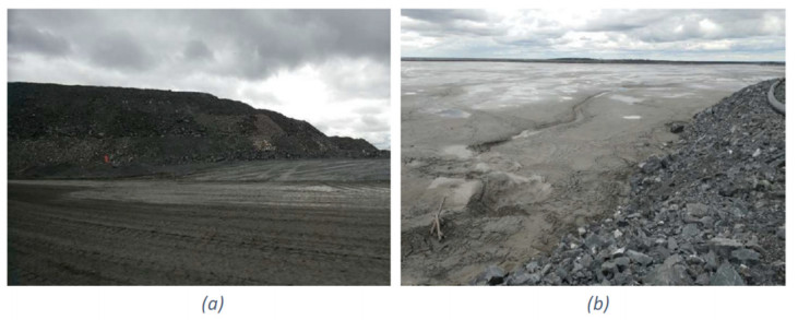
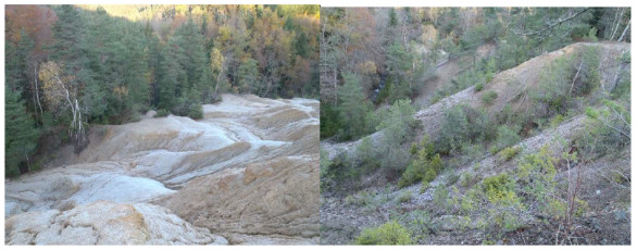
Mining operations generate a significant quantity of mining waste in the form of sterile rocks and processing residues. These mining wastes are typically placed on the surface and can cause geotechnical and geochemical disturbances, as well as contaminants in surface water (through runoff) and groundwater (through infiltration), thus posing environmental risks. This article aimed to characterize the geotechnical properties of lead-silver ore processing residues at the Auzelles site in order to assess their stability and propose recommendations for their management and rehabilitation. The adopted methodology included in situ tests (such as density measurement and permeability) and laboratory analyses (grain size distribution, moisture content, methylene blue test, direct shear test, and standard Proctor test). The results showed a wet density of 1.63 g/cm3 for the residues compared with 1.65 g/cm3 for the waste rock, as well as a permeability of the residues measured at 5.5 × 10⁻⁵ m/s, indicating significant drainage capacity. Laboratory analyses revealed that the samples were primarily composed of very silty sands and gravel, classified as B5 according to the Guide to Road Settlements. The cohesion of the residues was found to be zero, while the internal friction angle varied between 28° for the residues and 30° for the foundation soils. These geomechanical properties, particularly density, lack of cohesion, and friction angle values, raise concerns about the long-term stability of the residues. Due to their high permeability and lack of cohesion, the residues are susceptible to mass movement and erosion, which may exacerbate contamination risks. Therefore, it is essential to integrate these parameters into any potential residue stability analysis. Proactive management, based on these results, requires the implementation of appropriate rehabilitation techniques, such as drainage optimization and incorporation of vegetation covers, to minimize environmental impacts and ensure the long-term sustainability of mining waste structures.
Citation: Diaka Sidibé, Mamadou Diallo, Ahmed Amara Konaté, Muhammad Zaheer. Geotechnical investigations of lead-silver ore processing residues at the Auzelles site, Auvergne (France)[J]. AIMS Geosciences, 2024, 10(4): 735-758. doi: 10.3934/geosci.2024036
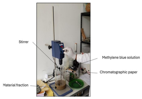
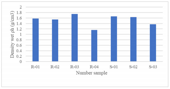
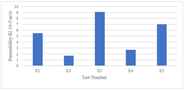
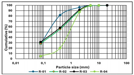
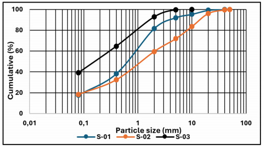
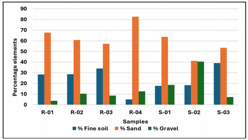
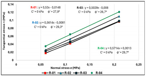
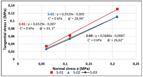
Mining operations generate a significant quantity of mining waste in the form of sterile rocks and processing residues. These mining wastes are typically placed on the surface and can cause geotechnical and geochemical disturbances, as well as contaminants in surface water (through runoff) and groundwater (through infiltration), thus posing environmental risks. This article aimed to characterize the geotechnical properties of lead-silver ore processing residues at the Auzelles site in order to assess their stability and propose recommendations for their management and rehabilitation. The adopted methodology included in situ tests (such as density measurement and permeability) and laboratory analyses (grain size distribution, moisture content, methylene blue test, direct shear test, and standard Proctor test). The results showed a wet density of 1.63 g/cm3 for the residues compared with 1.65 g/cm3 for the waste rock, as well as a permeability of the residues measured at 5.5 × 10⁻⁵ m/s, indicating significant drainage capacity. Laboratory analyses revealed that the samples were primarily composed of very silty sands and gravel, classified as B5 according to the Guide to Road Settlements. The cohesion of the residues was found to be zero, while the internal friction angle varied between 28° for the residues and 30° for the foundation soils. These geomechanical properties, particularly density, lack of cohesion, and friction angle values, raise concerns about the long-term stability of the residues. Due to their high permeability and lack of cohesion, the residues are susceptible to mass movement and erosion, which may exacerbate contamination risks. Therefore, it is essential to integrate these parameters into any potential residue stability analysis. Proactive management, based on these results, requires the implementation of appropriate rehabilitation techniques, such as drainage optimization and incorporation of vegetation covers, to minimize environmental impacts and ensure the long-term sustainability of mining waste structures.

| [1] | Opris RI (2017) Caractérisation des résidus miniers à l'aide d'essais de pénétration à cône. Université de Montréal. Available from: https://publications.polymtl.ca/2905/. |
| [2] | Aubertin M, Bussière B, Bernier L (2002) Environnement et gestion des rejets miniers. Presses Internationales Polytechnique. Available from: https://publications.polymtl.ca/26881/. |
| [3] | Toussaint R (2016) Influences des caractéristiques physico-chimiques de résidus miniers sulfureux sur leur réactivité à l'oxygène. Mémoire, Université de Montréal-, Canada. Available from: https://publications.polymtl.ca/2142/. |
| [4] | Romero CA (2013) Comportement dynamique du sol pulvérulent "résidus miniers. Mémoire, Université de Montréal, Canada. Available from: https://publications.polymtl.ca/1254/. |
| [5] |
Shengo LM (2012) Review of Practices in the Managements of Mineral Wastes: The Case of Waste Rocks and Mine Tailings. Water Air Soil Pollut 232: 273. https://doi.org/10.1007/s11270-021-05198-w doi: 10.1007/s11270-021-05198-w

|
| [6] |
Schweighofer B (1986) The geology of ore deposits. Meteorl. Atmos Phys 35: 253. https://doi.org/10.1007/BF01041818 doi: 10.1007/BF01041818
|
| [7] | Vick SG (1983) Planning, Design and Analysis of Tailings Dams. Available from: http://hdl.handle.net/2429/76455. |
| [8] | BRGM (2021) Plan de gestion du dépôt minier de la Molette. Concession d'Auzelles (63). France, Rapport RP-70315-FR. |
| [9] | BRGM (2020) Etude de phytostabilisation des sols du Terril, des Ravines et des Bassins du site minier d'Auzelles (63). |
| [10] | COMMISSION EUROPEENNE (2009) Gestion des résidus et stériles des activités minières. Available from: https://pdfdrive.to/dl/gestion-des-residus-et-steriles-des-activites-minieres. |
| [11] | Bolduc F (2012) Une étude sur l'utilisation des roches stériles comme inclusions drainantes dans les résidus miniers. Mémoire, Université de Montréal, Canada. Available from: https://publications.polymtl.ca/867/. |
| [12] | Punia A, Singh SK (2021) Contamination of water resources in the mining region. Contamination of water. Academic Press, 3–17. https://doi.org/10.1016/B978-0-12-824058-8.00015-3 |
| [13] |
Franks DM, Boger DV, Côte CM, et al. (2021) Sustainable development principles for the disposal of mining and mineral processing wastes. Resour Policy 36: 114–122. https://doi.org/10.1016/j.resourpol.2010.12.001 doi: 10.1016/j.resourpol.2010.12.001
|
| [14] |
Alfonso P, Ruiz M, Zambrana RN, et al. (2022) Process mineralogy of the tailings from Llallagua: towards a sustainable activity. Minerals 12: 214. https://doi.org/10.3390/min12020214 doi: 10.3390/min12020214
|
| [15] | Alshawmar FA (2021) Shaking Table Testing of Geotechnical Response of Densified Fine-Grained Soils to Cyclic Loadings: Application to Highly Densified Tailings. Doctoral dissertation, Université d'Ottawa/University of Ottawa. |
| [16] | Pépin N (2010) Étude du comportement cyclique de résidus miniers avec inclusions drainantes par des essais sur table sismique, Mémoire, Université de Montréal, Canada. Available from: https://publications.polymtl.ca/257/. |
| [17] | GEODERIS (2014) Evaluation de l'impact environnemental et sanitaire lié aux dépôts miniers de la zone de la Molette (ancien site minier d'Auzelles). France, Rapport S 2014/051DE-14AUV2410. |
| [18] | Sanjuan B, Crouzet C, Brach M (2001) Caractérisation d'une contamination des eaux par l'arsenic. Exemples d'Auzon et d'Auzelles (Auvergne). Rapport BRGM/RP-50737-FR. Available from: http://infoterre.brgm.fr/rapports/RP-50737-FR.pdf. |
| [19] | NF P94-061-2 (1996) Sols: Reconnaissance et essais. Détermination de la masse volumique d'un matériau en place. AFNOR. Available from: https://www.boutique.afnor.org/fr-fr/norme/nf-p940612/sols-reconnaissance-et-essais-determination-de-la-masse-volumique-dun-mater/fa040227/11069 |
| [20] | NF P94-056 (1998) Sols: Reconnaissance et essais: Analyse granulométrique: Méthode par tamisage à sec après lavage. AFNOR. Available from: https://www.boutique.afnor.org/fr-fr/norme/nf-p94056/sols-reconnaissance-et-essais-analyse-granulometrique-methode-par-tamisage-/fa026936/11075. |
| [21] | NF P94-050 (1995) Sols: Reconnaissance et essais: Détermination de la teneur en eau naturelle. AFNOR. Available from: https://www.boutique.afnor.org/fr-fr/norme/nf-p94050/sols-reconnaissance-et-essais-determination-de-la-teneur-en-eau-ponderale-d/fa020542/73303 |
| [22] | NF P94-068 (1998) Sols: Reconnaissance et essais - Mesure de la capacité d'adsorption de bleu de méthylène d'un sol ou d'un matériau rocheux - Détermination de la valeur de bleu de méthylène d'un sol ou d'un matériau rocheux par l'essai à la tache. AFNOR. Available from: https://www.boutique.afnor.org/fr-fr/norme/nf-p94068/sols-reconnaissance-et-essais-mesure-de-la-capacite-dadsorption-de-bleu-de-/fa043689/394#AreasStoreProductsSummaryView. |
| [23] | NF P94-071-1 (1994) Sols: Reconnaissance et essais: Essai de cisaillement rectiligne. AFNOR. Available from: https://www.boutique.afnor.org/fr-fr/norme/nf-p940711/sols-reconnaissance-et-essais-essai-de-cisaillement-rectiligne-a-la-boite-p/fa029769/11060. |
| [24] | NF P94-093 (2014) Reconnaissance et essais - Détermination des références de compactage d'un matériau - Essai Proctor Normal - Essai Proctor modifié. AFNOR. Available from: https://www.boutique.afnor.org/fr-fr/norme/nf-p94093/sols-reconnaissance-et-essais-determination-des-references-de-compactage-du/fa185491/43924#AreasStoreProductsSummaryView. |
| [25] | Moulay EA (2014) Étude paramétrée de la stabilité des barrages poids. Mémoire, Université Abou Bekr Belkaid, Algérie. Available from: http://dspace.univ-tlemcen.dz/bitstream/112/6076/1/MOULAY%20ELBOUDKHILI.pdf. |
| [26] |
Seif El Dine B, Dupla JC, Frank R, et al. (2010) Mechanical characterization of matrix coarse-grained soils with a large-sized triaxial device. Can Geotech J 47: 425–438. http://dx.doi.org/10.1139/T09-113 doi: 10.1139/T09-113
|
| [27] | Gandonou M (2019) Effet des changements climatiques sur la stabilité géotechnique d'un parc à résidus. Mémoire, Université de Montréal, Canada. Available from: https://publications.polymtl.ca/3911/. |
| [28] | Vincent A (2020) Etude de stabilité des résidus miniers issus du traitement de minerai d'uranium à Arlit (Niger), Niger. |
| [29] | Mustapha Jaouhar El (2012) Analyse de l'effet d'inclusions drainantes sur la consolidation de sols fins et de résidus miniers. Mémoire, Polytechnique Montréal, Canada. Available from: https://publications.polymtl.ca/996/. |

Figures(22) / Tables(1)

Diaka Sidibé, Mamadou Diallo, Ahmed Amara Konaté, Muhammad Zaheer. Geotechnical investigations of lead-silver ore processing residues at the Auzelles site, Auvergne (France)[J]. AIMS Geosciences, 2024, 10(4): 735-758. doi: 10.3934/geosci.2024036


 DownLoad: