The Taklimakan Desert is one of the largest deserts and sand seas in the world and plays a critical role in the global aerosol (eolian dust) system, impacting both climate and ecosystems on continents and over oceans. Geological evidence suggests that much of the western part of the Tarim Basin, which is now covered by the vast sandy desert, was once the eastern fringe of the Paratethys Sea. After the retreat of the sea, the area transformed into a fluvial system before becoming an mountain front alluvial fan system due to the uplift of the northern Tibetan Plateau. Deserts developed during this period, as sand dunes and eolian loess deposits were formed and buried to become part of the sedimentary sequence. Dating of these sequences suggests that the Taklimakan Desert, in a similar form to what we observe today, came into existence no later than 25 million years ago. Taklimakan Desert was formed as a response to a combination of widespread regional aridification due to the rain shadow effect and increased erosion in the surrounding mountain fronts, both of which are closely linked to the tectonic uplift of the Tibetan-Pamir Plateau and Tian Shan, which had reached a climatically sensitive threshold at this time.
Citation: Hongbo Zheng, Bihui Zhang, Huan Xu, Xiaochun Wei, Ryuji Tada, Qing Yang, Wanshu Yang. Birth of the Taklamakan Desert: When and How?[J]. STEM Education, 2023, 3(1): 57-69. doi: 10.3934/steme.2023005
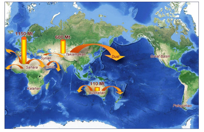
The Taklimakan Desert is one of the largest deserts and sand seas in the world and plays a critical role in the global aerosol (eolian dust) system, impacting both climate and ecosystems on continents and over oceans. Geological evidence suggests that much of the western part of the Tarim Basin, which is now covered by the vast sandy desert, was once the eastern fringe of the Paratethys Sea. After the retreat of the sea, the area transformed into a fluvial system before becoming an mountain front alluvial fan system due to the uplift of the northern Tibetan Plateau. Deserts developed during this period, as sand dunes and eolian loess deposits were formed and buried to become part of the sedimentary sequence. Dating of these sequences suggests that the Taklimakan Desert, in a similar form to what we observe today, came into existence no later than 25 million years ago. Taklimakan Desert was formed as a response to a combination of widespread regional aridification due to the rain shadow effect and increased erosion in the surrounding mountain fronts, both of which are closely linked to the tectonic uplift of the Tibetan-Pamir Plateau and Tian Shan, which had reached a climatically sensitive threshold at this time.

| [1] |
Shao, Y.P., Wyrwoll, K.H., Chappell, A., Huang, J., Lin, Z., McTainsh, G.H., et al., Dust cycle: An emerging core theme in Earth system science. Aeolian Research, 2011, 2(4):181‒204. https://doi.org/10.1016/j.aeolia.2011.02.001 doi: 10.1016/j.aeolia.2011.02.001

|
| [2] |
Zheng, H., Asia dust production ramped up since latest Oligocene driven by Tibetan Plateau uplift. National Science Review, 2016, 3: 271–274. https://doi.org/10.1093/nsr/nww028 doi: 10.1093/nsr/nww028
|
| [3] |
Uno, I., Eguchi, K., Yumimoto, K., Takemura, T., Shimizu, A., Uematsu, M., et al., Asian dust transported one full circuit around the globe. Nature Geoscience, 2009, 2(8): 557‒560. https://doi.org/10.1038/ngeo583 doi: 10.1038/ngeo583
|
| [4] | Zhu, Z.D., Wu, Z., Liu, S., Di, X., An Outline of Chinese Deserts. Science Press, Beijing, 1980. |
| [5] |
Zheng, H., Wei, X.C., Tada, R. et al., Late Oligocene–early Miocene birth of the Taklimakan Desert. Proceedings of the National Academy of Sciences, 2015,112(25): 7662‒7667. https://doi.org/10.1073/pnas.1424487112 doi: 10.1073/pnas.1424487112
|
| [6] |
Bosboom, R., Dupont-Nivet, G., Grothe, A., Brinkhuis, H., Villa, G., Mandic, O., et al., Linking Tarim Basin sea retreat (west China) and Asian aridification in the late Eocene. Basin Research, 2014, 26(5): 621‒640. https://doi.org/10.1111/bre.12054 doi: 10.1111/bre.12054
|
| [7] |
Ramstein, G., Fluteau, F., Besse, J., Joussaume, S., Effect of orogeny, plate motion and land-sea distribution on Eurasian climate change over the past 30 million years. Nature, 1997,386(6627): 788‒795. https://doi.org/10.1038/386788a0 doi: 10.1038/386788a0
|
| [8] |
Zheng, H., Powell, C.M., An, Z.S., et al., Pliocene uplift of the northern Tibetan Plateau. Geology, 2000, 28(8): 715‒718. https://doi.org/10.1130/0091-7613(2000)28 < 715:PUOTNT > 2.0.CO; 2 doi: 10.1130/0091-7613(2000)28 < 715:PUOTNT > 2.0.CO; 2
|
| [9] |
Zheng, H., Chen, H., Cao, J., Palaeoenvironmental implication of the Plio-Pleistocene loess deposits in southern Tarim Basin. Chinese Science Bulletin, 2002, 47: 700–704. https://doi.org/10.1007/BF02902833 doi: 10.1007/BF02902833
|
| [10] |
Zheng, H., Powell, C.M., Butcher, K., Cao, J., Late Neogene loess deposition in southern Tarim Basin: tectonic and palaeoenvironmental implications. Tectonophysics, 2003,375(1-4): 49‒59. https://doi.org/10.1016/S0040-1951(03)00333-0 doi: 10.1016/S0040-1951(03)00333-0
|
| [11] | Zheng, H., Tada, R., Jia, J. et al. Cenozoic sediments in the southern Tarim Basin: implications for the uplift of northern Tibet and evolution of the Taklimakan Desert. In Clift, P. D., Tada, R. & Zheng, H. (eds) Monsoon Evolution and Tectonics–Climate Linkage in Asia. Geological Society of London, Special Publications, 2010,342: 67‒78. https://doi.org/10.1144/SP342.6 |
| [12] |
Sun, X.J., Wang, .P.X., How old is the Asian monsoon system? Palaeobotanical records from China. Palaeogeography Palaeoclimatology Palaeoecology, 2005,222(3-4): 181‒222. https://doi.org/10.1016/j.palaeo.2005.03.005 doi: 10.1016/j.palaeo.2005.03.005
|


Figures(8)
Hongbo Zheng, Bihui Zhang, Huan Xu, Xiaochun Wei, Ryuji Tada, Qing Yang, Wanshu Yang. Birth of the Taklamakan Desert: When and How?[J]. STEM Education, 2023, 3(1): 57-69. doi: 10.3934/steme.2023005


 DownLoad: