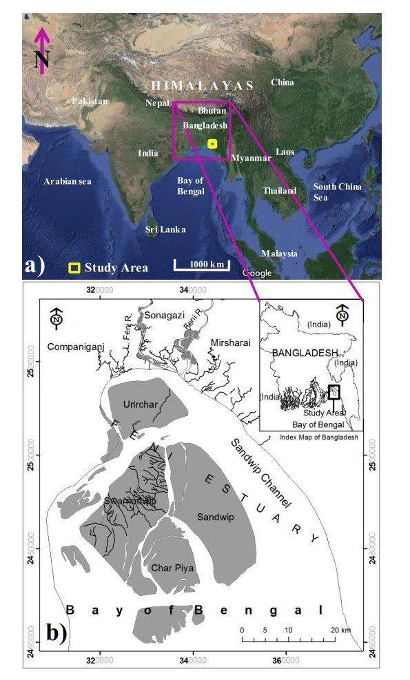
In coastal areas, to take any development plan, it is important to determine the stability of the coast and coastal islands. Therefore, the present research took an initiative to illustrate the development of coastal islands in the Feni estuary of Bangladesh through Remote Sensing (RS) and Geographic Information System (GIS) techniques. Multi-dated Landsat images of 1978, 1989, 2014 and 2020 were used in the study. The research reveals that in 1978, 1989, 2014 and 2020, the total area of various islands in the estuary was 377,650,894 and 1063 km2, respectively. The islands show cyclical growth and erosion, but their main components have existed for decades. During the period from 1978 to 1989, 1989 to 2014 and 2014 to 2020 about 330,386 and 379 km2 of new land added to the existing land mass and about 57,142 and 210 km2 of existing land eroded, respectively. Finally, from 1978 to 2020, the size of the islands increased by about 14.64 km2 yr-1. During the same period about 110 and 40 km2 lands along the coastline were eroded and accreted, in the north-western and eastern parts of the estuary, respectively. The study further reveals that the islands of the estuary have developed over the past few decades, except Sandwip. Finally, the outputs of this study will be helpful for policy makers and planners for sustainable estuary management.
Citation: Md. Bazlar Rashid, Md. Abdur Rahman. Coastline change and coastal islands development in the Feni estuary of Bangladesh through RS and GIS[J]. AIMS Geosciences, 2022, 8(4): 609-626. doi: 10.3934/geosci.2022033
In coastal areas, to take any development plan, it is important to determine the stability of the coast and coastal islands. Therefore, the present research took an initiative to illustrate the development of coastal islands in the Feni estuary of Bangladesh through Remote Sensing (RS) and Geographic Information System (GIS) techniques. Multi-dated Landsat images of 1978, 1989, 2014 and 2020 were used in the study. The research reveals that in 1978, 1989, 2014 and 2020, the total area of various islands in the estuary was 377,650,894 and 1063 km2, respectively. The islands show cyclical growth and erosion, but their main components have existed for decades. During the period from 1978 to 1989, 1989 to 2014 and 2014 to 2020 about 330,386 and 379 km2 of new land added to the existing land mass and about 57,142 and 210 km2 of existing land eroded, respectively. Finally, from 1978 to 2020, the size of the islands increased by about 14.64 km2 yr-1. During the same period about 110 and 40 km2 lands along the coastline were eroded and accreted, in the north-western and eastern parts of the estuary, respectively. The study further reveals that the islands of the estuary have developed over the past few decades, except Sandwip. Finally, the outputs of this study will be helpful for policy makers and planners for sustainable estuary management.

| [1] | Ahsan K, Rashid MB, Talukder S (2022) Tidal River Siltation and its Impact in the Coastal Parts of Bangladesh. Int J Econ Environ Geol 13: 35–41. |
| [2] | Islam MA, Majlis ABK, Rashid MB (2011) Changing Face of Bangladesh Coast. JNOAMI 28: 1–17. |
| [3] | Rashid MB, Ahsan K, Majlis ABK, et al. (2022) Sedimentation and Coastal Area Management in the human-modified Ganges-Brahmaputra tidal delta plain of Bangladesh. Int J River Basin Manage, 1–37. https://doi.org/10.1080/15715124.2022.2092489 |
| [4] | Rashid MB, Sheikh MR, Haque AJME, et al. (2022) Climate Change Impact and Frequency of Cyclone Surge in Bangladesh Coast: Proper Plan to Address Sustainably. Int J Econ Environ Geol 13: 15–20. |
| [5] |
Ratnayake NP, Ratnayake AS, Azoor RM, et al. (2019) Erosion processes driven by monsoon events after a beach nourishment and breakwater construction at Uswetakeiyawa beach, Sri Lanka. S N Appl Sci 1: 1–11. https://doi.org/10.1007/s42452-018-0050-7 doi: 10.1007/s42452-018-0050-7

|
| [6] | Yanli T (2002) The application of GIS and RS for coastline change detection and risk assessment to enhanced sea level rise, Institute of Geo-information science and earth observation, ITC, Enschede. Available from: https://webapps.itc.utwente.nl/librarywww/papers/msc_2002/ereg/tang_yanli.pdf. |
| [7] |
Brammer H (2014) Bangladesh's dynamic coastal regions and sea-level rise. Clim Risk Manage 1: 51–62. https://doi.org/10.1016/j.crm.2013.10.001 doi: 10.1016/j.crm.2013.10.001
|
| [8] |
Hasan GMJJ, Matin N (2019) Estimation of Areal Changes along the Coastline of Bangladesh due to Erosion and Accretion. Int J Eng Sci 12: 111–117. https://doi.org/10.36224/ijes.120305 doi: 10.36224/ijes.120305
|
| [9] |
Mahmood R, Ahmed N, Zhang L, et al. (2020) Coastal vulnerability assessment of Meghna estuary of Bangladesh using integrated geospatial techniques. Int J Disaster Risk Re 42: 101374. https://doi.org/10.1016/j.ijdrr.2019.101374 doi: 10.1016/j.ijdrr.2019.101374
|
| [10] |
Marfai MA, Almohammad H, Dey S, et al. (2008) Coastal dynamic and shoreline mapping: multi-sources spatial data analysis in Semarang Indonesia. Environ Monit Assess 142: 297–308. https://doi.org/10.1007/s10661-007-9929-2 doi: 10.1007/s10661-007-9929-2
|
| [11] | Paul BK, Rashid H (2017) Coastal LandformChanges: Coastal Erosion, Land Accretion and Subsidence. Clim Hazards Coastal Bangladesh, 121–152. https://doi.org/10.1016/B978-0-12-805276-1.00004-1 |
| [12] | Rashid MB, Mahmud A (2011) Longshore Currents and Its Effect on Kuakata Beach, Bangladesh. Bangladesh J Geol 29–30: 30–40. |
| [13] | Ahsan K, Rashid MB (2016) Coastal Process in the Cox's Bazar-Teknaf Area of the Eastern Coast of Bangladesh, Book of Abstracts. Ninth International Conference on Coastal and Port Engineering in Developing Countries (PIANC-COPEDEC IX), Brazil, 118. |
| [14] | Ahsan K, Rashid MB, Habib MA, et al. (2009) The Changing Geometry of the Cox's Bazar-Badarmokam Coast, Bangladesh. Bangladesh J Geol 26–28: 25–36. |
| [15] | Emran A, Rob MA, Kabir MH (2017) Coastline Change and Erosion- Accretion Evolution of the Sandwip Island, Bangladesh. Int J Appl Geospatial Res 8. https://doi.org/10.4018/IJAGR.2017040103 |
| [16] | Eysink WD (1983) Basic considerations of the morphology and land accretion potentials in the Estuary of the lower Meghna River. Bangladesh Water Deve Board Land Reclam Proj. |
| [17] | Hunter WW (1876) Chittagong Hill Tracts, Chittagong, Noakhali, Tipperah, Hill Tipperah. A Statistical Account of Bengal, Trübner and Co., London. |
| [18] | Sarkar MH, Choudhury E (2003) Knowledge Portal on Estuary Development, Water Resources Planning Organization (WARPO). |
| [19] | Alam AKMK (2001) Geomorphology and neotectonics of the mid-northern part of Bangladesh, based on remote sensing data (Abs). J Nepal Geol Soc 24: 1–2. |
| [20] |
Beratan KK, Anderson R (1998) The use of landsat thematic mapper data for mapping and correlation of Quaternary geomorphic surfaces in the whipple mountains, California. Int J Remote Sens 19: 2345–2359. https://doi.org/10.1080/014311698214767 doi: 10.1080/014311698214767
|
| [21] | Lillesand TM, Kiefer RW (2000) Remote Sensing and Image Interpretation, 4 Eds., John Wiley & Sons, New York, 750. |
| [22] | Rashid MB, Habib MA, Khan R, et al. (2021) Land transform and its consequences due to the route change of the Brahmaputra River in Bangladesh. Int J River Basin Manage, 1–13. https://doi.org/10.1080/15715124.2021.1938095 |
| [23] | Rashid MB, Islam SU, Badrul I (2015) Drainage characteristics and evolution of the Barind Tract, Bangladesh. Am J Earth Sci 1: 86–98. |
| [24] | Rashid MB, Islam SU, Badrul I (2018) Physiography of the Barind Tract and Its Surrounding Areas, Bengal Basin, Bangladesh. Am J Earth Sci 5: 1–9. |
| [25] | Sesoren A (1984) Geological Interpretation on Landsat Imagery of the Bangladesh Ganges Delta. ITC J 3: 229–232. |
| [26] |
Ciritci D, Türk T (2020) Analysis of coastal changes using remote sensing and geographical information systems in the Gulf of Izmit, Turkey. Environ Monit Assess 192: 341. https://doi.org/10.1007/s10661-020-08255-9 doi: 10.1007/s10661-020-08255-9
|
| [27] |
Kankara RS, Selvan SC, Markose VJ, et al. (2015) Estimation of long and short term shoreline changes along Andhra Pradesh coast using remote sensing and GIS techniques. Procedia Eng116: 855–862. https://doi.org/10.1016/j.proeng.2015.08.374 doi: 10.1016/j.proeng.2015.08.374
|
| [28] |
Palamakumbure L, Ratnayake AS, Premasiri HM et al. (2020) Sea-level inundation and risk assessment along the south and southwest coasts of Sri Lanka. Geoenviron Disasters 7: 1–9. https://doi.org/10.1186/s40677-020-00154-y doi: 10.1186/s40677-020-00154-y
|
| [29] |
Ratnayake AS, Ratnayake NP, Sampei Y, et al. (2018) Seasonal and tidal influence for water quality changes in coastal Bolgoda Lake system, Sri Lanka. J Coast Conserv 22: 1191–1199. https://doi.org/10.1007/s11852-018-0628-7 doi: 10.1007/s11852-018-0628-7
|
| [30] |
Weerasingha WADB, Ratnayake AS (2022) Coastal landform changes on the east coast of Sri Lanka using remote sensing and geographic information system (GIS) techniques. Remote Sens Appl Soc Environ 26: 100763. https://doi.org/10.1016/j.rsase.2022.100763 doi: 10.1016/j.rsase.2022.100763
|
| [31] |
Coleman JM (1969) Brahmaputra River: Channel Processes and Sedimentation. Sediment Geol 3: 129–239. https://doi.org/10.1016/0037-0738(69)90010-4 doi: 10.1016/0037-0738(69)90010-4
|
| [32] |
Goodbred SL Jr, Kuehl SA, Stecler MS, et al. (2003) Controls on facies distribution and stratigraphic preservation in the Ganges-Brahmaputra delta sequence. Sediment Geol 155: 301–316. https://doi.org/10.1016/S0037-0738(02)00184-7 doi: 10.1016/S0037-0738(02)00184-7
|
| [33] | Khan MG (2010) Bangladesh coastal and marine fisheries, and environment. Sustainable Manage Fish Resour Bay Bengal, 1–35. |
| [34] | IECOO, Operation and Maintenance manual for project major works, Muhuri Irrigation Project, 1983. Available from: https://projects.worldbank.org/en/projects-operations/project-detail/P009380 |
| [35] | Khan MR (2002) Plate Tectonics and Bangladesh. J Asiat Soc Bangladesh Sci 28: 39–62. |
| [36] |
Murty TS, El-Sabh MI (1992) Mitigating the effects of storm surges generated by tropical cyclones: a proposal. Nat Hazards 6: 251–273. https://doi.org/10.1007/BF00129511 doi: 10.1007/BF00129511
|
| [37] | SMRC, The Vulnerability Assessment of the SAARC Coastal Region Due to Sea Level Rise: Bangladesh Case Study. SAARC Meteorological Research Center, 2003. Available from: https://www.scirp.org/(S(czeh2tfqyw2orz553k1w0r45))/reference/ReferencesPapers.aspx?ReferenceID=2214172 |
| [38] |
Islam MA, Mitra D, Dewan A, et al. (2016) Coastal multi-hazard vulnerability assessment along the Ganges deltaic coast of Bangladesh- geospatial approach. Ocean Coast Manag 127: 1–15. https://doi.org/10.1016/j.ocecoaman.2016.03.012 doi: 10.1016/j.ocecoaman.2016.03.012
|
| [39] | Haider R, Rahman A, Huq S (1991) Cyclone 91: an environmental and perception study. Bangladesh Cent Adv Stud, 91. |
| [40] | Paul A, Rahman MM, Mahbub AQM (2002) Role of shelter center for cyclone hazard mitigation in Cox's Bazar, Bangladesh. Chittagong Univ J Sci 26: 113–123. |
| [41] |
Rashid MB (2020) Channel bar development and bankline migration of the Lower Padma River of Bangladesh. Arab J Geosci 13: 612. https://doi.org/10.1007/s12517-020-05628-9 doi: 10.1007/s12517-020-05628-9
|
| [42] | Rashid MB, Habib MA (2022) Channel bar Development, Braiding and Bankline Migration of the Brahmaputra-Jamuna River, Bangladesh through RS and GIS techniques. Int J River Basin Manage. https://doi.org/10.1080/15715124.2022.2118281 |
| [43] | Rennell's (1779) Bengal and Bahar in Atlas. Act of Perliamant, James Rennell's Map. American Geographical Society Library Digital Map Collection, Available from: https://uwm.edu/libraries/digital-collections/copyright-digcoll/. |
| [44] | Hirst FC (1917) The Surveys of Bengal by Major James Rennell, 1764–1777, The Bengal Secretariat Book Department. |
| [45] |
Yang X, Damen MCJ, van Zuidam RA (1999) Satellite remote sensing and GIS for the analysis of channel migration changes in the active Yellow river delta, China. JAG 1: 146–157. https://doi.org/10.1016/S0303-2434(99)85007-7 doi: 10.1016/S0303-2434(99)85007-7
|
| [46] | Agarwal CS, Garg PK (2000) Textbook on Remote Sensing in Natural Resources Monitoring and Management, Wheeler Publishing, New Delhi, India. |
| [47] | Yasir M, Hui S, Hongxia Z, et al. (2021) A Spatiotemporal Change Detection Analysis of Coastline Data in Qingdao, East China. Sci Program. https://doi.org/10.1155/2021/6632450 |
| [48] |
Baig MRI, Ahmad IA, Shahfahad Tayyab M, et al. (2020) Analysis of shoreline changes in Vishakhapatnam coastal tract of Andhra Pradesh, India: an application of digital shoreline analysis system (DSAS). Ann GIS 26: 361–376. https://doi.org/10.1080/19475683.2020.1815839 doi: 10.1080/19475683.2020.1815839
|
| [49] | Lazaridou MA (2012) Image Interpretation of Coastal Areas, Int. Arch. Photogramm. Remote Sens. Spatial Inf Sci XXXIX-B8: 171–174. https://doi.org/10.5194/isprsarchives-XXXIX-B8-171-2012 |
| [50] |
Alam AKMK, Islam MB (2017) Recent changes in Jadukata fan (Bangladesh) in response to Holocene tectonics. Quat Int 462: 226–235. http://dx.doi.org/10.1016/j.quaint.2017.08.014 doi: 10.1016/j.quaint.2017.08.014
|
| [51] |
Winterbottom SJ (2000) Medium and short-term channel planform changes on the rivers Tay and Tummel, Scotland. Geomorphology 34: 195–208. https://doi.org/10.1016/S0169-555X(00)00007-6 doi: 10.1016/S0169-555X(00)00007-6
|
| [52] | Rob MA (1997) Shifting course of the Ganges in Bangladesh: A study in fluvial morphology. Dhaka Univ J Sci 45: 193–204. |
| [53] | Sarker MH, Akter J, Ferdous, et al. (2011) Sediment dispersal processes and management in coping with climate change in the Meghna Estuary, Bengal Delta, Bangladesh. Sediment Problems and Sediment Management in Asian River Basins Proceedings of the ICCE Workshop held at Hyderabad, India. |
| [54] | Rashid MB, Mahmud A, Ahsan MK, et al. (2013) Drainage Congestion and Its Impact on Environment in the South-Western Coastal Part of Bangladesh. Bangladesh J Geol 26: 359–371. |
| [55] |
Siddique MAB, Khan R, Islam, ARMT, et al. (2021) Quality assessment of freshwaters from a coastal city of southern Bangladesh: Irrigation feasibility and preliminary health risks appraisal. Environ Nanotechnol Monit Manage 16: 100524. https://doi.org/10.1016/j.enmm.2021.100524 doi: 10.1016/j.enmm.2021.100524
|


Figures(12) / Tables(5)

Md. Bazlar Rashid, Md. Abdur Rahman. Coastline change and coastal islands development in the Feni estuary of Bangladesh through RS and GIS[J]. AIMS Geosciences, 2022, 8(4): 609-626. doi: 10.3934/geosci.2022033


 DownLoad: