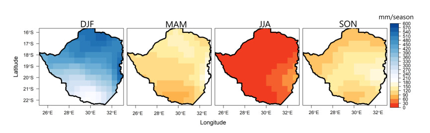
This study examines how the atmospheric circulation patterns in Africa south of the equator govern the spatial distribution of precipitation in Zimbabwe. The moisture circulation patterns are designated by an ample set of eight classified circulation types (CTs). Here it is shown that all wet CTs over Zimbabwe features enhanced cyclonic/convective activity in the southwest Indian Ocean. Therefore, enhanced moisture availability in the southwest Indian Ocean is necessary for rainfall formation in parts of Zimbabwe. The wettest CT in Zimbabwe is characterized by a ridging South Atlantic Ocean high-pressure, south of South Africa, driving an abundance of southeast moisture fluxes, from the southwest Indian Ocean into Zimbabwe. Due to the proximity of Zimbabwe to the Agulhas and Mozambique warm current, the activity of the ridging South Atlantic Ocean anticyclone is a dominant synoptic feature that favors above-average rainfall in Zimbabwe. Also, coupled with a weaker state of the Mascarene high, it is shown that a ridging South Atlantic Ocean high-pressure, south of South Africa, can be favorable for the southwest movement of tropical cyclones into the eastern coastal landmasses resulting in above-average rainfall in Zimbabwe. The driest CT is characterized by the northward track of the Southern Hemisphere mid-latitude cyclones leading to enhanced westerly fluxes in the southwest Indian Ocean, limiting moist southeast winds into Zimbabwe.
Citation: Chibuike Chiedozie Ibebuchi, Itohan-Osa Abu. Relationship between synoptic circulations and the spatial distributions of rainfall in Zimbabwe[J]. AIMS Geosciences, 2023, 9(1): 1-15. doi: 10.3934/geosci.2023001
This study examines how the atmospheric circulation patterns in Africa south of the equator govern the spatial distribution of precipitation in Zimbabwe. The moisture circulation patterns are designated by an ample set of eight classified circulation types (CTs). Here it is shown that all wet CTs over Zimbabwe features enhanced cyclonic/convective activity in the southwest Indian Ocean. Therefore, enhanced moisture availability in the southwest Indian Ocean is necessary for rainfall formation in parts of Zimbabwe. The wettest CT in Zimbabwe is characterized by a ridging South Atlantic Ocean high-pressure, south of South Africa, driving an abundance of southeast moisture fluxes, from the southwest Indian Ocean into Zimbabwe. Due to the proximity of Zimbabwe to the Agulhas and Mozambique warm current, the activity of the ridging South Atlantic Ocean anticyclone is a dominant synoptic feature that favors above-average rainfall in Zimbabwe. Also, coupled with a weaker state of the Mascarene high, it is shown that a ridging South Atlantic Ocean high-pressure, south of South Africa, can be favorable for the southwest movement of tropical cyclones into the eastern coastal landmasses resulting in above-average rainfall in Zimbabwe. The driest CT is characterized by the northward track of the Southern Hemisphere mid-latitude cyclones leading to enhanced westerly fluxes in the southwest Indian Ocean, limiting moist southeast winds into Zimbabwe.

| [1] | AfDB (2011) Infrastructure and growth in Zimbabwe: an action plan for sustained strong economic growth. Summary Report. Available from: https://www.afdb.org/fileadmin/uploads/afdb/Documents/Generic-Documents/1.%20Standalone%20Summary%20Report.pdf |
| [2] |
Unganai L (2009) Adaptation to climate change among agropastoral systems: case for Zimbabwe. IOP Conf Ser Earth Environ Sci 6: 412045. https://doi.org/10.1088/1755-1307/6/41/412045 doi: 10.1088/1755-1307/6/41/412045

|
| [3] | Mutasa C (2008) Evidence of climate change in Zimbabwe: paper presented at the climate change awareness and dialogue. Workshop for Mashonaland Central and Mashonaland West Provinces held at Caribbea Bay Hotel, Kariba, Zimbabwe. 29–30 September. |
| [4] | GoZ (2010) Medium term plan, January 2010–December 2015. Government of Zimbabwe, Ministry of Economic Planning and Investment Promotion, Harare. |
| [5] | Chagutah T (2010) Climate change vulnerability and preparedness in Southern Africa: Zimbabwe Country Report. Heinrich Boell Stiftung, Cape Town. |
| [6] | IPCC (2007) Climate Change 2007—Impacts, Adaptation and Vulnerability: Working Group Ⅱ Contribution to the Fourth Assessment Report of the Intergovernmental Panel on Climate Change, Cambridge, UK: Cambridge University Press, 469–506. Available from: https://www.ipcc.ch/site/assets/uploads/2018/03/ar4_wg2_full_report.pdf. |
| [7] | WFP (2019) How drought is killing Zimbabwe. Available from: https://www.wfp.org/stories/how-drought-killing-zimbabwe. |
| [8] | Nyahunda L, Tirivangasi HM (2021) Barriers to Effective Climate Change Management in Zimbabwe's Rural Communities. African Handbook of Climate Change Adaptation. Springer, Cham. https://doi.org/10.1007/978-3-030-45106-6_251 |
| [9] |
Cook KH (2000) The South Indian convergence zone and interannual rainfall variability over Southern Africa. J Climate 13: 3789–3804. https://doi.org/10.1175/1520-0442(2000)013<3789:TSICZA>2.0.CO;2 doi: 10.1175/1520-0442(2000)013<3789:TSICZA>2.0.CO;2
|
| [10] |
Macron C, Pohl B, Richard Y, et al. (2014) How do tropical-temperate troughs form and develop over southern Africa? J Climate 27: 1633–1647. https://doi.org/10.1175/JCLI-D-13-00175.1 doi: 10.1175/JCLI-D-13-00175.1
|
| [11] |
Hart NC, Reason CJC, Fauchereau N (2012) Cloud bands over southern Africa: seasonality, contribution to rainfall variability and modulation by the MJO. Clim Dynam 41: 1199–1212. https://doi.org/10.1007/s00382-012-1589-4 doi: 10.1007/s00382-012-1589-4
|
| [12] |
Vigaud N, Richard Y, Rouault M, et al. (2009) Moisture transport between the South Atlantic Ocean and Southern Africa: relationships with summer rainfall and associated dynamics. Clim Dynam 32: 113–123. https://doi.org/10.1007/s00382-008-0377-7 doi: 10.1007/s00382-008-0377-7
|
| [13] |
Reason CJC, Mulenga H (1999) Relationships between South African rainfall and SST anomalies in the southwest Indian Ocean. Int J Climatol 19: 1651–1673. https://doi.org/10.1002/(SICI)1097-0088(199912)19:15<1651::AID-JOC439>3.0.CO;2-U doi: 10.1002/(SICI)1097-0088(199912)19:15<1651::AID-JOC439>3.0.CO;2-U
|
| [14] |
Munday C, Washington R, Hart N (2020) African low-level jets and their importance for water vapor transport and rainfall. Geophys Res Lett 48: e2020GL090999. https://doi.org/10.1029/2020GL090999 doi: 10.1029/2020GL090999
|
| [15] | Ibebuchi CC (2022) Circulation patterns linked to the positive sub-tropical Indian Ocean dipole. Adv Atmos Sci. https://doi.org/10.1007/s00376-022-2017-2 |
| [16] |
Barimalala R, Blamex RC, Desbiolles F, et al. (2020) Variability in the Mozambique Channel Trough and impacts on Southeast African rainfall. J Climate 33: 749–765. https://doi.org/10.1175/JCLI-D-19-0267.1 doi: 10.1175/JCLI-D-19-0267.1
|
| [17] |
Ibebuchi CC (2021) On the relationship between circulation patterns, the southern annular Mode, and rainfall variability in Western Cape. Atmosphere 12: 753. https://doi.org/10.3390/atmos12060753 doi: 10.3390/atmos12060753
|
| [18] | Reason CJC, Rouault M (2005) Links between the Antarctic Oscillation and winter rainfall over western South Africa. Geophys Res Lett 32. https://doi.org/10.1029/2005GL022419 |
| [19] |
Richard Y, Trzaska S, Roucou P, et al. (2000) Modification of the southern African rainfall variability/ENSO relationship since the late 1960s. Clim Dynam 16: 883–895. https://doi.org/10.1007/s003820000086 doi: 10.1007/s003820000086
|
| [20] |
Dieppois B, Rouault M, New M (2015) The impact of ENSO on southern African rainfall in CMIP5 ocean atmosphere coupled climate models. Clim Dynam 45: 2425–2442. https://doi.org/10.1007/s00382-015-2480-x doi: 10.1007/s00382-015-2480-x
|
| [21] |
Ibebuchi CC (2021) Revisiting the 1992 severe drought episode in South Africa: the role of El Niñ o in the anomalies of atmospheric circulation types in Africa south of the equator. Thero Appl Climatol 146: 723–740. https://doi.org/10.1007/s00704-021-03741-7 doi: 10.1007/s00704-021-03741-7
|
| [22] |
Mamombe V, Kim WM, Choi YS (2017) Rainfall variability over Zimbabwe and its relation to large‐scale atmosphere-ocean processes. Int J Climatol 37: 963–971. https://doi.org/10.1002/joc.4752 doi: 10.1002/joc.4752
|
| [23] |
Hersbach H, Bell B, Berrisford P, et al. (2020) The ERA5 global reanalysis. Q J R Meteor Soc 146: 1999–2049. https://doi.org/10.1002/qj.3803 doi: 10.1002/qj.3803
|
| [24] |
Xie P, Chen M, Yang S, et al. (2007) A gauge-based analysis of daily precipitation over East Asia. J Hydrometeorol 8: 607–626. https://doi.org/10.1175/JHM583.1 doi: 10.1175/JHM583.1
|
| [25] |
Ibebuchi CC (2021) Circulation pattern controls of wet days and dry days in Free State, South Africa. Meteorol Atmos Phys 133: 1469–1480. https://doi.org/10.1007/s00703-021-00822-0 doi: 10.1007/s00703-021-00822-0
|
| [26] |
Richman MB (1981) Obliquely rotated principal components: an improved meteorological map typing technique? J Appl Meteorol Clim 20: 1145–1159. https://doi.org/10.1175/1520-0450(1981)020<1145:ORPCAI>2.0.CO;2 doi: 10.1175/1520-0450(1981)020<1145:ORPCAI>2.0.CO;2
|
| [27] |
Gong X, Richman MB (1995) On the application of cluster analysis to growing season precipitation data in North America east of the rockies. J Climate 8: 897–931. https://doi.org/10.1175/1520-0442(1995)008<0897:OTAOCA>2.0.CO;2 doi: 10.1175/1520-0442(1995)008<0897:OTAOCA>2.0.CO;2
|
| [28] |
Xing YF, Xu YH, Shi MH, et al. (2016) The impact of PM2.5 on the human respiratory system. J Thorac Dis 8: E69–E74. https://doi.org/10.3978/j.issn.2072-1439.2016.01.19 doi: 10.3978/j.issn.2072-1439.2016.01.19
|
| [29] |
Uele DL, Lyra GB, De Oliveira Júnior JF (2017) Spatial and intrannual variability of rainfall in south region of the Mozambique, Southern Africa. Rev Bras Meteorol 32: 473–484. https://doi.org/10.1590/0102-77863230013 doi: 10.1590/0102-77863230013
|
| [30] |
Ndarana T, Bopape MJ, Waugh D, et al. (2018) The influence of lower stratosphere on ridging Atlantic Ocean Anticyclone over South Africa. J Climate 31: 6175–6187. https://doi.org/10.1175/JCLI-D-17-0832.1 doi: 10.1175/JCLI-D-17-0832.1
|
| [31] |
Reason CJC (2007) Tropical cyclone Dera, the unusual 2000/01 tropical cyclone season in the South West Indian Ocean and associated rainfall anomalies over Southern Africa. Meteorol Atmos Phys 97: 181–188. https://doi.org/10.1007/s00703-006-0251-2 doi: 10.1007/s00703-006-0251-2
|
| [32] |
Ibebuchi CC (2022) Can synoptic patterns influence the track and formation of tropical cyclones in the Mozambique Channel? AIMS Geosci 8: 33–51. https://doi.org/10.3934/geosci.2022003 doi: 10.3934/geosci.2022003
|
| [33] | UNCT Zimbabwe (2020) Floods disaster in Zimbabwe. Available from: https://reliefweb.int/report/zimbabwe/floods-disaster-zimbabwe. |
| [34] |
Crimp SJ, Mason SJ (1999) The extreme precipitation event of 11 to 16 February 1996 over South Africa. Meteorol Atmos Phys 70: 29–42. https://doi.org/10.1007/s007030050023 doi: 10.1007/s007030050023
|
| [35] |
Jury MR (2015) Passive suppression of South African rainfall by Agulhas current. Earth Interact 19: 1–14. https://doi.org/10.1175/EI-D-15-0017.1 doi: 10.1175/EI-D-15-0017.1
|
| [36] |
Engelbrecht CJ, Landman WA, Engelbrecht FA, et al. (2015) A synoptic decomposition of rainfall over the Cape south coast of South Africa. Clim Dynam 44: 2589–2607. https://doi.org/10.1007/s00382-014-2230-5 doi: 10.1007/s00382-014-2230-5
|
| [37] |
Stander JH, Dyson L, Engelbrecht CJ (2016) A snow forecasting decision tree for significant snowfall over the interior of South Africa. S Afr J Sci 112: 1–10. https://doi.org/10.17159/sajs.2016/20150221 doi: 10.17159/sajs.2016/20150221
|
| [38] |
De Oliveira-Júnior JF, Shah M, Abbas A, et al. (2022) Spatiotemporal analysis of drought and rainfall in Pakistan via Standardized Precipitation Index: homogeneous regions, trend, wavelet, and influence of El Niñ o-southern oscillation. Theor Appl Climatol 149: 843–862. https://doi.org/10.1007/s00704-022-04082-9 doi: 10.1007/s00704-022-04082-9
|
| [39] |
Zeri M, Cunha-Zeri G, Gois G, et al. (2019) Exposure assessment of rainfall to interannual variability using the wavelet transform. Int J Climatol 39: 568–578. https://doi.org/10.1002/joc.5812 doi: 10.1002/joc.5812
|
| [40] |
Correia Filho WLF, De Oliveira-Júnior JF, De Barros Santiago D, et al. (2019) Rainfall variability in the Brazilian northeast biomes and their interactions with meteorological systems and ENSO via CHELSA product. Big Earth Data 3: 315–337. https://doi.org/10.1080/20964471.2019.1692298 doi: 10.1080/20964471.2019.1692298
|


Figures(7) / Tables(1)

Chibuike Chiedozie Ibebuchi, Itohan-Osa Abu. Relationship between synoptic circulations and the spatial distributions of rainfall in Zimbabwe[J]. AIMS Geosciences, 2023, 9(1): 1-15. doi: 10.3934/geosci.2023001


 DownLoad: