Research article Special Issues

Environmental knowledge, risk prevention, renaissance suggestions in the time of COVID-19

  • In recent months, humanity, is experiencing a set of situations that have completely changed the existing balances, worldwide. The pandemic from COVID-19 brings the collective memory back to the terrible Spanish flu, thought to have infected a third of the world's population and killed at least 50 million people, between January 1918 and December 1920.
    Approximately one hundred years later, the whole society is facing with a virus—per se weak, but extremely agile in contagion—and the most delicate problem is, once again, how to manage the emergency, how to mitigate the consequences of damage, and how to get the normal living conditions again. One of the consequences of the pandemic, is obviously a widespread economic crisis.
    One of the most relevant resources of the Italian country is the Landscape, an unquestionable attraction, due to its geological origin and development.
    This work proposes a vision on the situation we are living, aiming at suggesting one of the possible ways to escape some of the virus’s damages, by implementing a balanced fruition/administration/management of the territorial resources.

    Citation: Piero Farabollini, Francesca Romana Lugeri, Emy Fuffa. Environmental knowledge, risk prevention, renaissance suggestions in the time of COVID-19[J]. AIMS Geosciences, 2020, 6(3): 258-270. doi: 10.3934/geosci.2020015

    Related Papers:

    [1] Francesca Romana Lugeri, Piero Farabollini, Francesco De Pascale, Nicola Lugeri . PPGIS applied to environmental communication and hazards for a community-based approach: a dualism in the Southern Italy "calanchi" landscape. AIMS Geosciences, 2021, 7(3): 490-506. doi: 10.3934/geosci.2021028
    [2] Francesca Romana Lugeri, Piero Farabollini, Nicola Lugeri . Landscape analysis as a tool for risk reduction. AIMS Geosciences, 2019, 5(3): 617-630. doi: 10.3934/geosci.2019.3.617
    [3] Francesca Romana Lugeri, Barbara Aldighieri, Piero Farabollini, Fabrizio Bendia, Alberto Cardillo . Territorial knowledge and cartographic evolution. AIMS Geosciences, 2022, 8(3): 452-466. doi: 10.3934/geosci.2022025
    [4] Rajeev Singh Chandel, Shruti Kanga, Suraj Kumar Singh . Impact of COVID-19 on tourism sector: a case study of Rajasthan, India. AIMS Geosciences, 2021, 7(2): 224-243. doi: 10.3934/geosci.2021014
    [5] Giulia de Spuches, Francesca Sabatini, Gabriella Palermo, Emanuela Caravello . Risk narrations and perceptions in the COVID-19 time. A discourse analysis through the Italian press. AIMS Geosciences, 2020, 6(4): 504-514. doi: 10.3934/geosci.2020028
    [6] Santus Daniela . Perception, representation and narration of environmental and urban risk: Floods, earthquakes, desertification, pollution, health, gentrification. AIMS Geosciences, 2024, 10(4): 759-766. doi: 10.3934/geosci.2024037
    [7] Giovanni Gugg . Beyond the volcanic risk. To defuse the announced disaster of Vesuvius. AIMS Geosciences, 2019, 5(3): 480-492. doi: 10.3934/geosci.2019.3.480
    [8] Elisabetta Dall’Ò . Historicizing vulnerability: place-names, risk and memory in the Mont Blanc area. AIMS Geosciences, 2019, 5(3): 493-508. doi: 10.3934/geosci.2019.3.493
    [9] Gianni Petino, Gaetano Chinnici, Donatella Privitera . Heritage and carob trees: Where the monumental and landscape intersect. AIMS Geosciences, 2024, 10(3): 623-640. doi: 10.3934/geosci.2024032
    [10] Matteo Bona . Comprehending the risk throughout a literary-geocritical approach. Rushdie's The Satanic Verses as evidence and an opportunity in investigating risk scenarios. AIMS Geosciences, 2024, 10(2): 419-435. doi: 10.3934/geosci.2024022
  • In recent months, humanity, is experiencing a set of situations that have completely changed the existing balances, worldwide. The pandemic from COVID-19 brings the collective memory back to the terrible Spanish flu, thought to have infected a third of the world's population and killed at least 50 million people, between January 1918 and December 1920.
    Approximately one hundred years later, the whole society is facing with a virus—per se weak, but extremely agile in contagion—and the most delicate problem is, once again, how to manage the emergency, how to mitigate the consequences of damage, and how to get the normal living conditions again. One of the consequences of the pandemic, is obviously a widespread economic crisis.
    One of the most relevant resources of the Italian country is the Landscape, an unquestionable attraction, due to its geological origin and development.
    This work proposes a vision on the situation we are living, aiming at suggesting one of the possible ways to escape some of the virus’s damages, by implementing a balanced fruition/administration/management of the territorial resources.


    Italy is a country extremely characterized by natural risks (seismic, hydrogeological), due to its nature, its geographical position and geomorphological configuration.

    The Italian civil protection system is one of the best in the world, precisely because of the numerous types of emergency it has to face. One of the most difficult obstacles is the management of the social response to the hazard. Even in the case of health risk—more immediate to perceive than seismic and hydrogeological ones—the social response is difficult to manage. Incredulity and superficiality vs. anguish and obsession: extreme poles of an unbalanced approach to reality. A strategic objective to be able to recover the social/economical balances is to recognize, share and implement the resilience to individuals/communities/society.

    One of the consequences of the pandemic, is obviously a widespread economic crisis. In our country, the tourism sector—one of the most important economic resource—is deeply affected. The long-time engagement in the sector of management and enhancement of the Italian territory, leads us to analyze the situation from an environmental point of view, in the aim at proposing some useful solutions to revitalize both the society and the economy, while respecting social health and environmental protection. It seems clear that the first driving factors will derive from domestic tourism, due to the desire of the Italians to finally leave the house, after the lockdown. This is due to the fact that our country was among the first to experience coronavirus contagion, respect to other countries. Despite the uncertainties about the times and the modalities of the restart, we will try to suggest some new ways to enjoy the environmental beauties of our country, making such resources more attractive to the Italian public, starting from new policies in terms of communication.

    To this aim, new ways in reaching a complete and effective understanding of territory, are a great resource, even at the level of tourism, which is a primary resource in the postmodern age [1]. The knowledge of one’s own territory, is the first step towards a conscious knowledge, aimed to risk prevention and sustainable development as well.

    Knowing the environment in which we live, of which we are part, is a process of fundamental importance in the development of each individual: today, more than ever, it assumes an “undeniable strategic value”, depending o its survival. The difficult trip towards harmonization between man and environment winds on a complex path, guided by a scientific knowledge and personal sensitivity. Different types of approach to natural sciences have characterized, in the various eras, this path of individual/community/society, conditioned by the peculiar historical, political, socio economic phases. Today has matured the consciousness of the opportunity of an integrated, holistic, approach, towards the knowledge, taking into account all the aspects that constitute the complexity that nature itself presents.

    In this perspective, environment represents what human perceive and interact with: source of emotions, risks and resources. Landscape ecology offers a new scientific approach towards environment study, while on the socio-political front, the European Landscape sanctions its important functions as a cultural, ecological, environmental and social value. Landscape is everywhere, an “important element of people quality life” and cooperates in the elaboration of local cultures representing a fundamental component of Europe's cultural and natural heritage, thus contributing to well-being and satisfaction of human beings and consolidation of European identity. A new awareness is strictly linked to the participation of populations in playing an active role in the landscape transformation, a useful resource that can be used if supported by new territorial planning perspectives, aimed at increasing the qualities of the landscape itself and the associated individual and social well-being, in the consciousness that a correct safeguard and management policy entails rights and responsibilities for each individual [2].

    Interaction between individual/community/society, with the environment is based on knowledge and experience, and winds on a structured path between opposite poles: risk and resource.

    A correct technical and cultural approach to the problem of environmental management and risk requires a multiscale and multidisciplinary methodological approach, useful for directing decision-making orientations and management activities to achieve delicate but progressively more stable balances, between use and respect for the territory, with a develop that necessary has to be sustainable for the ecosystem, natural and social. The balanced use of resources, useful for the survival and health of society, can be brought towards excellence through the enhancement of the territory [3]. Both functions can only be based on knowledge, which, in this context, can be properly summarized, made usable and shareable trough cartographic restitution, instrument that always represents significant themes, providing them with a perceptive immediacy.

    Thanks to the potential made accessible by science and technology and because of the intense modification and alteration produced on the environment by the progress, the necessity to effectively deal with the study of the territory (as a result of human environment interaction) has become critical. The cognitive process consists in identifying and monitoring the state of the natural environment, trough the constitution of models based on an updatable, multiscale system, competent of containing information concerning the physical, biotic and anthropic aspects of the territory, considered both individually and in their integration and mutual interaction [4]. Trough the modern territorial information system, the representation is associated with a database that furnish significant values to each graphic element. The “Nature Map” is the figure represented below, and shows some aspects of an ecological-environmental cartography project [5].

    The different quantity of information, relating to the various components that allow a complete reading of the territory, are integrated thanks to GIS. The flexibility and upgradeability of this type of instrument is perfectly appropriate associated to a function for monitoring the evolution of environmental balances; at the same time they constitute a great diffusion tool, modern and usable for different needs and at different levels of depth, useful for a wide target audience [6].

    The Landscape Ecology approach [7] which takes into consideration the features of natural and artificial ecosystem as a parts of a single diversified system, is a fundamental basis for any correct planning hypothesis that pursues the protection of the area's aesthetic and cultural resources and the opportunities for social and economic, in a harmonious relationship with the concept of safeguarding natural resources and fruitful interaction with places. Environment diversity can be considered in its components and sectioned trough organization hierarchy levels; its conservation cannot be separated from integrated studies on living and ecosystem, geological heritage.

    One of the most complex and delicate questions for the Anthropocene’s society is about how to clearly understand and make understandable what risk is, and how to effectively communicate and manage it [8,9].

    The recent dramatic events, in Italy as well as in the world, confirm such problem. The concept of risk has long been poorly defined and subject to interpretation. Nowadays, thanks to the Probabilistic Risk Analysis approach, the process of risk assessment (or the determination of the extent of damage) is based on the assumption that the real risk results from the product of the probability of occurrence of a certain event for the extent (magnitude) of its harmful consequences [10,11].

    The risk, therefore, expresses the consequences of a particular harmful event; the expected number of loss of life, destruction of economic activities or natural resources, in other words, the risk is the product of the probability of an event occurring due to the size of the expected damage.

    The dialectical definition of risk integrates and clarify the analytical expressions: “… the possibility that human actions or events lead to consequences that have an impact on what men consider relevant” [12]. It is clear that we cannot escape from the disturbing awareness that the action of man is often at the base of many events with disastrous effects.

    Referring to the current situation, in Italy, the risk management strategies must be in a close relationship with the social tissues. Such condition constitutes the most relevant aspect of effective risk management, which is thus determined by at least four factors: objective characteristics of the risk; risk perception by individual/community/society; credibility of the guarantor of the potential source of risk; involvement and decision-making tools [3].

    In parallel, the basic elements identified as useful for risk management can be summarized as follows: identification of nature and the extent of public concerns [13]; the structuring of the public debate and conflict resolution; advance knowledge of public reactions to the introduction of new technologies; public education and information; planning and implementation of systems and policies related to the environment and health. Because of human action, nature usually escapes from previsions. The problem, political and social, is deeply embedded in history and unfortunately, still today, humanity does not to have yet maturated neither instinct nor wisdom such as to balance the tendency to presumption. Rather than confronting and respecting the laws of nature—not always completely understandable—Humans choose the path of exploitation and profit. And it is the same logic that, often, drives and feeds scientific research. Science aims at reaching knowledge, however, too often, scientific research is almost subordinate (even if chronologically precedes it) to different kinds of business. It is as if acting for profit, somehow resizes the dissonance between the human’s presumption of control and awareness of reality. If the sense of belonging prevailed, perhaps, a more comforting sensation would be obtained. Man tends to modify the environment, in order to adapt it to his needs: but nature, which unites the planet and its inhabitants, would like the adaptation of man to environment and no vice versa.

    Beyond the necessary diversification in the practical method of the problems related to environmental protection, there is a widespread and generalized tendency to separate cause from effect. It is quite logical to realize how this “trick” facilitates the removal of the component of human responsibility, direct or not, in what happens, especially in those cases of heavy alteration on the environmental balances. It happened: we remedy the damage and work to prevent other damage from occurring in other similar circumstances (this at least in the declaration of intent). That is the philosophy of the intervention after the event. Yet, the most balanced approach to the problem of risk management is the one oriented towards prevention, based on consciousness, and articulated between shared knowledge, education and awareness. On these bases it is possible to implement new protection policies, to support a healthy and responsible development of the individual in the environment.

    The recent COVID-19 pandemic crisis highlights the need of recovering a more balanced relationship between Humankind and Environment [14]. Global data about coronavirus epidemic and contagion, seem to suggest a significant link to the anthropic pressure, especially in terms of atmospheric pollution. Italian country, one of the most deeply hidden by epidemic, reveals that the highest COVID-19 infection's percentage is located in the North of the country, especially in those regions where the industrialization is more developed, and the related atmospheric pollution is very heavy. We are not yet able to support with a complete data analysis such kind of interrelation; however, it is almost intuitive to consider the role of air pollution in case of those epidemics whose effects—as the coronavirus syndrome is- are mostly referred to the human respiratory system. Social distancing and movement restrictions put one of the most important sectors of the Italian economy into crisis: tourism. Actually, the COVID-19 pandemic questions one of the most important contemporary issues: leisure, the social conquest of “free time” and “vacation/holiday”.

    Living in times of pandemic, a further risk is occurring: the so called Nature’s Deficit [15] defined as a syndromic condition, with possible clinical evidence in the physical field and, for our specific interest, with the repercussions in the affective-relational, communicative, neuropsychological one. With some dynamic ideas, then, on outdoor educational/re-educational experiences aimed especially at the world of school. When we consider the Nature Deficit Disorder we refer, in our reality, often to borderline frameworks, which are no longer physiological normality but not yet quite frank pathology: we say “under-health” conditions, induced by an early inactivity, facilitated by schooling and from free time not sufficiently spent outdoors, in nature, but at home, with homework and life spent in front of a screen, that of TV, computer, various electronic games. Staying at home, taken from sedentary occupations, takes away time primarily from physical activity, reduces energy consumption, eats more, and even badly, sometimes even conditioned by the habits advertised [16].

    The realization of GIS and maps is one of the most important activity performed within the Italian National Institute for Environmental Protection and Research (ISPRA). Such kind of production gives researchers, policy makers, stakeholders, and society, a kit of tools indispensable to understand the territorial settings characterizing our country. Digital mapping, Geographical Information Systems, and related data bases, allow us a complete analysis of the landscapes by integrating its components and the related dynamic pattern. Moreover, starting from Geomorphological Maps; Physiographic and environmental maps it is possible to create a special synthetic Map Italian landscapes, in correlation with those cultural issues significantly related to the territory, in comparison and integration with social-economic data. Particularly, the GIS provided researchers and users with an integrated data management and an agile sharing of information, an interactive use of tools and contents, according to different levels of complexity and needs.

    The so-called Map of Nature, born with the Italian Framework Law on protected areas, is a national project coordinated by ISPRA which “… identifies the state of the natural environment in Italy, highlighting the natural values and the profiles of territorial vulnerability …” [17].

    The project consists in two main phases; the first one provides for the identification of homogeneous territorial units at national scale: Map of Physiographic Landscapes Units Italians, 1:250,000 [18,19]; the second phase provides for the evaluation for each unit, aiming at assessing the environmental value and the risk of environmental degradation. The methodology followed in analysing landscape is related to the Landscape Ecology approach. The evaluation indexes are investigated in a spatial-temporal scale, following a holistic approach that consider all the components of an area, reciprocally interactive [18,21,22]. The final indexes used to represent the state of the habitat are: Ecological value, Ecological Sensitivity, Anthropogenic Pressure and Environmental Fragility.

    Let us devote a special attention to this topic: wine. This is one of the most important product on the national and global market, which has become a symbol of Italian culture throughout the world. Referring to some interesting news about the therapeutic options for the cure of the coronavirus syndrome, we can affirm that the Italian red wine, can be useful in mitigating some serious effects of the infection. Moreover, Resveratrol, naturally produced phenol produced by plants, such as vine and cocoa, has been already confirmed as capable of blocking the viral replication of Mers, a virus similar to Sars-Cov-2 [23].

    Starting from these researches, the Italian University Federico II University of Naples focuses on the synthesis of the natural molecule in tablets, containing both the phenol, and maltodextrin, to facilitate its absorption [24].

    Wine is an indisputable protagonist in Italy’s culture: it has its roots into the land, in every sense, representing a path of geo-ecological-environmental knowledge [25]. It also offers new opportunities to highlight the link between the Earth and its products [26]. A new interest for wine, based on the recognition of territory through its manifestation in landscape, can lead to the realization of effective strategies for territory management [27], with the consensus of the local population, towards a shared well-being (Figure 1).

    Figure 1.  Wine Landscapes in North East of Italy.

    In recent years, has been registered a growing attention about wine production and promotion. Being it a product deeply linked to its territory, the extraordinary profusion of studies, and the continuous attention of the winemakers, point to the need for guidelines in order to reach more balanced land use policies and practices.

    An innovative approach, aimed at integrating the use of natural resources and the traditional cultures, could help promote local development favourable for a better production and new chances of employment. By using GIS and the related databases it is possible to depict the complex and rich reality of the areas of production that is typical of Italian wines [28]; this approach represents a starting point for modern planning policies for wine-producing areas and leads to a greater understanding of the culture of Italian wines, leading to the promotion and improvement of this “fruit of our land” [29,30,31].

    A special attention is due to wine tourism, since it represents both an opportunity for local development and a creative approach to educational programs. By integrating data and information related to the territory where the wine is born, it is possible to realize maps of wine production areas, highlighting the landscape and its special settings, that give each wine its own characteristics [31,32,33]. Such kind of maps, made up thanks to GIS technology, can be edited at different level of complexity, for different kinds of use. The eco-tourism, for example, aiming at guiding trekkers through “winescapes” [30], providing tourists with scientific information, using a proper language, clear, simple (not simplified), and images representing the geological, geomorphological, hydrological settings of the area, as well as any further information, useful to better re-cognize the visited places, and feel part of a living eco-system (Figure 2).

    Figure 2.  Map of Ecological value of Veneto region—North East of Italy (ISPRA—ARPA VENETO).

    The COVID pandemic has clearly demonstrated how the environmental balances have a function in the virus' diffusion. Environmental impact of industries and infrastructures, air, water, and agricultural products’ quality, as well as eating habits, influence both the social health conditions and the social exposition to the contagion. Experience (including the one we are living, fighting the virus) teaches us that people barely accept the hazard consciousness. The concept of risk, as developed before, is too often rejected or underestimated, even if widely demonstrated.

    More effective seems to be an alternative approach, focused on a constructive message: how to manage hazard, and reduce risk, by creating sustainable ways in developing natural resources, in enhancing territory: a new approach, particularly focused on tourism, since it offers the opportunity to highlight the link between the Earth and its products [26].

    Let’s devote one more reflection to Wine: as told before, its properties can help in slowing some virus symptoms down. A further function may be performed by this product, as protagonist both of the Italian culture and economy. It is clear the significant link between each wine and the landscape where it is born. Italian wines, in particular, have “a tie to the land and therefore represents a path of geo-ecological-environmental knowledge” [30].

    The wine’s origin, on the geographical, geological, ecological level, deserves a better development both in the cultural debate and in scientific divulgation. A new field in studying the agricultural landscape, devotes attention to vineyards cultivation, and its integration in the surrounding landscape: the pattern characterizing the reciprocal position of natural, cultural, agricultural and anthropic landscapes, represents a significant indicator in the evaluation of the environmental value and the territorial fragility of the wine production areas. On such terms, the wine itself becomes a vector of information, making it easier the social participation in approaching environmental themes. The further step is the social involvement in reaching a common consciousness of being part of a dynamic ecosystem, in the aim at changing social behavior towards sustainability. Such objective must be chased by involving individual/community/society in processes of participative democracy.

    GIS and digital modern mapping are powerful tools, not only in scientific contexts. It is possible to synthesize and simplify information, graphic elaboration, and related database at various levels of complexity, referring to the target. Thanks to modern technology we can modulate the message by taking into consideration what are we communicating, as well as to whom goes the information. Such scientific based approach is the crucial step towards new policies in vineyards management and wine production, focusing on the enhancement of the social-cultural-economic value of Italian wines (Figure 3).

    Figure 3.  A path through the Italian “Terre del prosecco” UNESCO WHS, from Treviso to Valdobbiadene, based on the Map of Physiographic Units.

    It is crucial to aim at conscious knowledge, not only acquired but assimilated by the individual/community/society: only an articulated and complex process, shareable and in a continuous progress, can permit a profitable interaction between man and environment, the only effective way to the recovery of a balance not only lost, but also lost sight of over time. In this sense, the binomial protection of the habitat/personal growth is drawn up; an intent that should be spontaneous, however became almost an illusionThe protection needs for the territory are a priority, which forms an integral part of it (even if this coincidence is often forgotten). New environmental problems need the development of equally new study models and creative management strategies. The objective of identifying and enhancing territorial resources can only reached through directing development policies on an integration path between both ecological-naturalistic and socio-economic cultural demands.

    It is necessary to acquire a new point of view, which interprets the landscape as a results of all the anthropic and natural processes taking place in a complex mosaic of ecosystems, and in which can guide the territorial planning and management activities towards the creation of places of collective identification. At the same time, it is essential to activate sharing paths, which integrate educational steps, in order to unify individual psycho-physical development and natural environment.

    New steps in this direction have been encouraged by the International Year of Planet Earth, an UNESCO initiative that aims to share and make available the knowledge base related to Earth sciences, using codes accessible to all, in order to involve that whole society in environmental protection actions, through the common awareness of the realities that condition the evolution of our planet and humanity.

    Slow tourism is a new special kind of traveling that allows voyagers to take their personal time. In these Coronavirus times, such way of exploration could really bring benefits to our country.

    Tourism needs to change, on terms of ways, interests and expectations: slow tourism seems to be the right one for society, especially in this period, which we would never have thought of living in. By experiencing the social distancing, and the travel ban are suggesting us to live a different journey, whose primary objective the discovery of the territory, accessed as an integration between nature and culture.

    We will have the chance to explore the places, while experiencing places and cultures in a different way, by creating intimate connections with environment, landscape, society.

    Living such kind of experience, we will help ecological tourism, by learning how to appreciate the uncontaminated environment, as well as by rediscovering the most secret beauty of our country. Moreover, we will get a better consciousness about our country: such feeling can make us able to share a new way to visit our/every country, by knowing its environmental settings, enjoying its local culture, living its natural life.

    Khalil Gibran writes “Your home is your largest body”, the environment represents the home of humanity.

    The authors would like to thank Patrick O’Brien for the English revision, and Emiliano Canali for the figure.

    The authors declare no conflict of interest.


    [1] Sabato G (2014) Distretti turistici, i valori dell'immaginario. In: Cusimano G, Parroco AM, Purpura A (a Cura Di), I Distretti Turistici: Strumenti Di Sviluppo Dei Territori. L'Esperienza Nella Regione Sicilia, FrancoAngeli, 68-83.
    [2] Marincioni F, Casareale C, Byrne K (2019) Beautiful and Safe Landscapes for Sustainable Disaster Risk Reduction. Disaster Research and the Second Environmental Crisis, Springer, Cham, 105-116. doi: 10.1007/978-3-030-04691-0_5
    [3] 
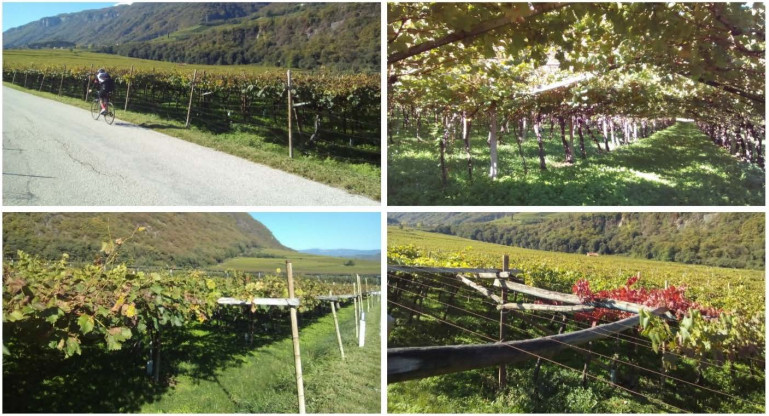
Lugeri FR, Farabollini P (2018) Discovering the Landscape by Cycling: A Geo-Touristic Experience through Italian Badlands. Geosciences 8: 291. doi: 10.3390/geosciences8080291
    [4] Lugeri FR, Farabollini P, Amadio V, et al. (2018) Unconventional Approach for Prevention of Environmental and Related Social Risks: A Geoethic Mission. Geosciences 8: 54. doi: 10.3390/geosciences8020054
    [5] Lugeri FR, Farabollini P, Greco R, et al. (2015) The Geological Characterization of Landscape in Major TV Series: A Suggested Approach to Involve the Public in the Geological Heritage Promotion. Sustainability 7: 4100-4119. doi: 10.3390/su7044100
    [6] Lugeri F, Farabollini P, Lugeri N (2019) Landscape analysis as a tool for risk reduction. AIMS Geosci 5: 617-630. doi: 10.3934/geosci.2019.3.617
    [7] Forman RTT, Godron M (1986) Landscape Ecology. NewYork: John Wiley and Sons.
    [8] Farabollini P, Lugeri FR, Amadio V, et al. (2014) The role of Earth Sciences and Landscape Approach in the Ethic Geology: Communication and Divulgation for the Prevention and Reduction of Geological Hazards. In: Lollino G, Arattano M, Giardino M, et al. (Eds.), Engineering Geology for Society and Territory-Volume 7. Heidelberg, Germany: Springer, 115-120.
    [9] De Pascale F, Dattilo V (2019) La sémiosis de l'Anthropocène: pour une réinterprétation de la relation entre l' homme et la nature par le biais de la géoéthique. Riv Geogr Ital 18: 23-40.
    [10] Cerase A, Maggi M (2018) Editoriale, PRISMA-Numero monografico su Rischi ambientali e comunicazione. Prism Soc 3: 5-13.
    [11] Cannizzaro S, De Pascale F, Farabollini P, et al. (2020) Introduction to the Special Issue "Socio-Natural Disasters and Vulnerability Reduction in the territorial ecosystems". AIMS Geosci 6: 1-5. doi: 10.3934/geosci.2020001
    [12] Renn O, Webler T, Kastenholz H (1996) Perception of Uncertainty: Lessons for Risk Management and Communication. In: Sublet VH, Covello VT, Tinker TL, (Eds.), Scientific Uncertainty and Its Influence on the Public Communication, 163-181. doi: 10.1007/978-94-015-8619-1_7
    [13] Farabollini P (2019) The 2016 Earthquake in Central Italy. The Alphabet of Reconstruction. In: Farabollini P, Lugeri FR, Mugnano S (Eds.), Earthquake risk perception, communication and mitigation strategies across Europe 2: 145-171.
    [14] De Pascale F, Roger JC (2020) Coronavirus: An Anthropocene's hybrid? The need for a geoethic perspective for the future of the Earth. AIMS Geosci 6: 131-134.
    [15] Magnaguagno F (2009) Natura Umana e progetto Versante NORD: un nuovo approccio al disagio giovanile. Montagna solidale. I versanti della montagnaterapia. Atti del Convegno Nazionale di montagnaterapia. Pomezia, 31-64.
    [16] Miletto R, Aversano M, Magnaguagno F, et al. (2009) Il Nature Deficit Disorder. Montagna solidale. I versanti della montagnaterapia. Atti del Convegno Nazionale di montagnaterapia. ITOP ed. Palestrina, 23-30.
    [17] Italian Law 394/91 (1991) GU Serie Generale n.292 del 13-12-1991 - Suppl. Ordinario n. 83.
    [18] Amadio V, Amadei M, Bagnaia R, et al. (2002) The role of Geomorphology in Landscape Ecology: the Landscape Unit Map of Italy, Scale 1:250,000 (Carta della Natura" Project). In: Allison RJ (Ed.), Applied Geomorphology: Theory and Practice, London, UK: Wiley, 265-282.
    [19] APAT (2003) Carta della natura alla scala 1:250,000: metodologie di realizzazione. Manuali e linee guida 17/2003, Roma, Italy (in Italian).
    [20] APAT (2004) Carta della natura alla scala 1:50,000: metodologie di realizzazione. Manuali e linee guida 30/2004, Roma, Italy: APAT (in Italian).
    [21] Naveh Z, Lieberman A (1994) Landscape Ecology Theory and Application. Heidelberg, Germany: Springer.
    [22] Turner, MG, Gardner RH. O'Neill RV (2001) Landscape Ecology in Theory and Practice: Pattern and Process. New York, USA: Springer.
    [23] Li G, De Clercq E (2020) Therapeutic options for the 2019 novel coronavirus (2019-nCoV). Nat Rev Drug Discov 19: 149-150. doi: 10.1038/d41573-020-00016-0
    [24] Annunziata G, Maisto M, Schisano C, et al. (2019) Effects of Grape Pomace Polyphenolic Extract (Taurisolo®) in Reducing TMAO Serum Levels in Humans: Preliminary Results from a Randomized, Placebo-Controlled, Cross-Over Study. Nutrients 11: 139. doi: 10.3390/nu11010139
    [25] Gregori L (2004) Percorsi geoturistici ed enografici in Umbria. Atti del 2° Convegno Geologia & Turismo "Opportunità nell'economia del paesaggio", Bologna, 58-60. (in Italian).
    [26] Montanari A, Costa N, Staniscia B (2008) Geografia del gusto. Scenari per l'Abruzzo. Menabò.
    [27] Brilha J (2002) Geoconservation and protected areas. Environ Conserv 29: 273-276. doi: 10.1017/S0376892902000188
    [28] Lugeri FR, Farabollini P, Lugeri N, et al. (2017) "LandscApp": a friendly way to share the Italian geo-heritage. Acta Geoturistica 8: 79-86. doi: 10.1515/agta-2017-0008
    [29] Angelini S, Farabollini P, Spurio E (2009) I sistemi informativi geografici nella definizione dei terroir vitivinicoli: una applicazione nel terroir della Vernaccia doc di Serrapetrona (Marche centrali). Atti del Convegno Internazionale-I paesaggi del vino: cartografia e paesaggi, Perugia, Italy: Boll, AIC, 55-78.
    [30] Gregori L (2007) La cartografia "emozionale" dei paesaggi del vino. La Cartogr 14: 14-29.
    [31] Lugeri FR, Amadio V, Bagnaia R, et al. (2011) Landscapes and Wine Production Areas: A Geomorphological Heritage. Geoheritage 3: 221-232. doi: 10.1007/s12371-011-0035-z
    [32] Cita BM, Chiesa S, Colacicchi R, et al. (2004) Italian wines and geology. Paesaggi Geologici, Milan: BE-MA editrice.
    [33] Colacicchi R, Parotto M (2006) Geologia dei vini italiani, Italia centrale. Paesaggi geologici, Milan: BE-MA editrice, 175.
  • Reader Comments
  • © 2020 the Author(s), licensee AIMS Press. This is an open access article distributed under the terms of the Creative Commons Attribution License (http://creativecommons.org/licenses/by/4.0)
通讯作者: 陈斌, bchen63@163.com
  • 1. 

    沈阳化工大学材料科学与工程学院 沈阳 110142

  1. 本站搜索
  2. 百度学术搜索
  3. 万方数据库搜索
  4. CNKI搜索

Metrics

Article views(3740) PDF downloads(192) Cited by(0)

Figures and Tables

Figures(3)

/

DownLoad:  Full-Size Img  PowerPoint
Return
Return

Catalog