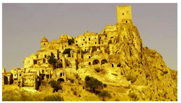
The need of protection of the territory is a priority for the society, which is an integral part of it (unfortunately, this coincidence is often forgotten): the new environmental issues require the development of innovative management strategies and of appropriate knowledge and models. The balanced use of resources, essential for the survival and well-being of society, can be optimised through the promotion of the territory. The identification and the sustainable development of local resources can only be achieved by directing development policies towards a path of integration between ecological needs, protection of the landscape and socio-economic and cultural needs. The landscape, read as a result of the interaction between human and natural processes, is a rich heritage to safeguard, enhance and promote. The key requirement underlying each cultural and environmental enhancement project is the knowledge of the territory in its manifold aspects; knowledge that can be properly synthesised through cartographic representation: maps are tools to make data easily accessible and meaningful. In this contribution, after having carried out a review of the literature on GIS technologies and having provided some work examples, we analyse some proposals about the application of PPGIS on communication of environmental promotion initiatives; PPGIS, in fact, are effective in risk communication and information and in the consequent prevention of disasters. The mediated and participatory use of PPGIS technologies, furthermore, allows a community-based approach, fundamental for reducing the disaster risk.
Citation: Francesca Romana Lugeri, Piero Farabollini, Francesco De Pascale, Nicola Lugeri. PPGIS applied to environmental communication and hazards for a community-based approach: a dualism in the Southern Italy 'calanchi' landscape[J]. AIMS Geosciences, 2021, 7(3): 490-506. doi: 10.3934/geosci.2021028
The need of protection of the territory is a priority for the society, which is an integral part of it (unfortunately, this coincidence is often forgotten): the new environmental issues require the development of innovative management strategies and of appropriate knowledge and models. The balanced use of resources, essential for the survival and well-being of society, can be optimised through the promotion of the territory. The identification and the sustainable development of local resources can only be achieved by directing development policies towards a path of integration between ecological needs, protection of the landscape and socio-economic and cultural needs. The landscape, read as a result of the interaction between human and natural processes, is a rich heritage to safeguard, enhance and promote. The key requirement underlying each cultural and environmental enhancement project is the knowledge of the territory in its manifold aspects; knowledge that can be properly synthesised through cartographic representation: maps are tools to make data easily accessible and meaningful. In this contribution, after having carried out a review of the literature on GIS technologies and having provided some work examples, we analyse some proposals about the application of PPGIS on communication of environmental promotion initiatives; PPGIS, in fact, are effective in risk communication and information and in the consequent prevention of disasters. The mediated and participatory use of PPGIS technologies, furthermore, allows a community-based approach, fundamental for reducing the disaster risk.

| [1] | Council of Europe, Council of Europe Landscape Convention (Treaty n. 176), 2000. Available from: https://www.coe.int/en/web/conventions/full-list?module=treaty-detail&treatynum=176. |
| [2] | Lugeri FR, Farabollini P, Amadio V (2020) Geoheritage: A Strategic Resource for the Society in the Anthropocene. In: Singh RB, Wei D, Anand S, Global Geographical Heritage, Geoparks and Geotourism, Eds., Advances in Geographical and Environmental Sciences. Springer Verlag, 43-58. |
| [3] | Crutzen PJ (2006) The "Anthropocene". Earth system science in the anthropocene. Springer, Berlin/Heidelberg, Germany, 3-6. |
| [4] | Farabollini P, Lugeri FR, Lugeri N (2018) Humankind and Risk: a difficult history. In: Antronico L, Marincioni F, Natural Hazards and Disaster Risk Reduction Policies, Geographies of the Anthropocene book series, Eds., Lago: Il Sileno Edizioni, 88-103. Available from: http://www.ilsileno.it/geographiesoftheanthropocene. |
| [5] | Giddens A, Offe C, Touraine A (1987) Ecologia politica. Milano: Feltrinelli. |
| [6] | Farabollini P, Lugeri FR, Amadio V, et al. (2014) The role of Earth Sciences and Landscape Approach in the Ethic Geology: Communication and Divulgation for the Prevention and Reduction of Geological Hazards. Engineering Geology for Society and Territory, Heidelberg, Germany: Feltrinelli, 115-120. |
| [7] |
Lugeri FR, Farabollini P, Amadio V, et al. (2018) Unconventional Approach for Prevention of Environmental and Related Social Risks: A Geoethic Mission. Geosciences 8: 54. doi: 10.3390/geosciences8020054

|
| [8] |
Lugeri FR, Farabollini P, Greco R, et al. (2015). The Geological Characterization of Landscape in Major TV Series: A Suggested Approach to Involve the Public in the Geological Heritage Promotion. Sustainability 7: 4100-4119. doi: 10.3390/su7044100
|
| [9] |
Lugeri FR, Farabollini P, Lugeri N (2019) Landscape analysis as a tool for risk reduction. AIMS Geosci 5: 617-630. doi: 10.3934/geosci.2019.3.617
|
| [10] | Catton WR Jr, Dunlap RE (1978) Environmental Sociology. A New Paradigm. Am Sociologist 13: 41-49. |
| [11] | Forman RTT (1995) Land Mosaics: The Ecology of Landscapes and Regions, Cambridge, UK: Cambridge University Press. |
| [12] | Forman RTT, Godron M (1986) Landscape ecology, NewYork, USA: John Wiley and Sons. |
| [13] | Naveh Z, Lieberman AS (1994) Landscape Ecology Theory and Application. Series on Environmental Management, Heidelberg, Germany: Springer. |
| [14] | Turner MG, Gardner RH, O'Neill RV (2001) Landscape Ecology in Theory and Practice: Pattern and Process, New York, USA: Springer. |
| [15] | Dent, BD, Torguson JS, Hodler TW (2009) Cartography: Thematic map design. Boston, MA: WCB/McGraw-Hill. |
| [16] | Peterson G (2009) GIS Cartography: A Guide to Effective Map Design, Boca Raton: Taylor & Francis. |
| [17] | Harris T, Rouse L, Bergeron S (2010) The Geospatial Semantic Web, Pareto GIS, and the Humanities. In: Bodenhamer D, Corrigan J, Harris T, The Spatial Humanities: GIS and the Future of Humanities Scholarship, Eds., Indiana University Press, 124-143. |
| [18] |
Moore A (2015) Web Cartography-Map Design for Interactive and Mobile Devices. J Spat Sci 60: 195-196. doi: 10.1080/14498596.2015.1006113
|
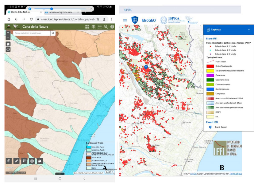
| [19] |
Sieber R (2006) Public Participation Geographic Information Systems: A Literature Review and Framework. Ann Assoc Am Geogr 96: 491-507. doi: 10.1111/j.1467-8306.2006.00702.x
|
| [20] | Haimes P, Baba T, Medley S (2015) Mobile map applications and the democratisation of hazard information. SIGGRAPH Asia 2015 Mobile Graphics and Interactive Applications, Association for Computing Machinery, New York, NY, USA, Article 7, 1-4. |
| [21] | McKinster J, Trautmann N, Barnett M (2013) Teaching Science and Investigating Environmental Issues with Geospatial Technology: Designing Effective Professional Development for Teachers, Springer Science & Business Media: Berlin, Germany, 353. |
| [22] | ISPRA. Available from: https://www.progettoiffi.isprambiente.it/cartografia-on-line. |
| [23] | Trigila A, Frattini P, Catani F, et al. (2013) Landslide Susceptibility Mapping at National Scale: The Italian Case Study, Landslide Science and Practice, Springer, Berlin, Heidelberg. |
| [24] |
Trigila A, Iadanza C, Spizzichino D (2010) Quality assessment of the Italian Landslide Inventory using GIS processing. Landslides 7: 455-470. doi: 10.1007/s10346-010-0213-0
|
| [25] | Trigila A, Iadanza C, Spizzichino D (2008) IFFI Project (Italian landslide inventory) and risk assessment, Proceedings of the First World Landslide Forum, Springer Verlag, 18-21. |
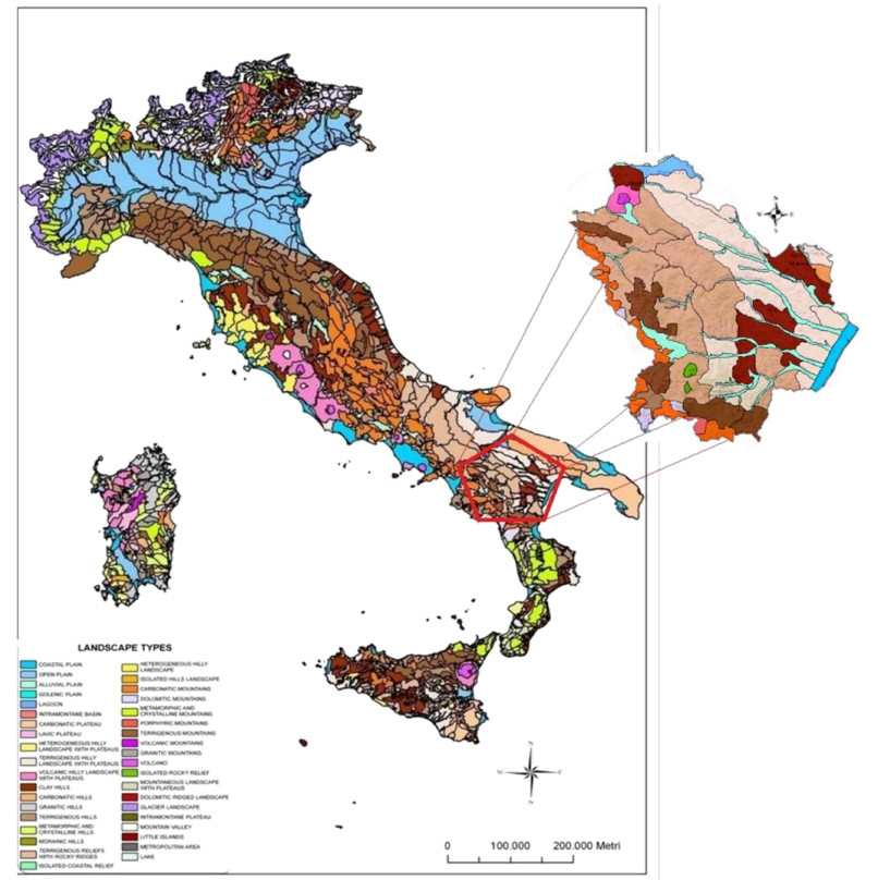
| [26] | Amadio V, Amadei M, Bagnaia R, et al. (2002) The role of Geomorphology in Landscape Ecology: the Landscape Unit Map of Italy, Scale 1: 250,000 (Carta della Natura Project). Applied Geomorphology: Theory and Practice, London, UK: Wiley, 265-282. |
| [27] | APAT (2003) Carta della natura alla scala 1: 250,000: metodologie di realizzazione. Manuali e linee guida 17/2003, Roma, Italy: APAT. |
| [28] | APAT (2004) Carta della natura alla scala 1: 50,000: metodologie di realizzazione. Manuali e linee guida 30/2004, Roma, Italy: APAT. |
| [29] | ISPRA Web GIS Carta della Natura. Available from: https://sinacloud.isprambiente.it/portal/apps/webappviewer/index.html. |
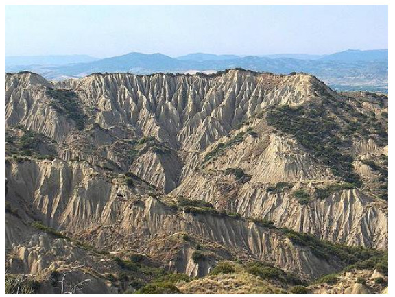
| [30] | Alexander DE (1982) Difference between "calanchi" and "biancane" badlands in Italy. Badland Geomorphology and Piping, Eds., Geo books: Norwhich, UK, 71-88. |
| [31] | Vittorini S (1979) Ruscellamento, deflusso ipodermico ed erosione nelle argille plastiche. Riv Geogr Ital 86: 338-436. |
| [32] | Del Prete M, Valentini G (1971) Le caratteristiche geotecniche delle Argille Azzurre dell'Italia sud-orientale in relazione alle differenti situazioni stratigrafiche e tettoniche. Geol Appl Idrogeol 6: 197-215. |
| [33] | Dramis F, Gentili B, Coltorti M, et al. (1982) Piano di Gestione. Riserva dei Calanchi di Montalbano Provincia di Matera 60. Osservazioni geomorfologiche sui calanchi. Geogr Fis Din Quat 5: 38-45. |
| [34] | Ciaranfi N, Gallicchio S, Girone A, et al. (2010) Proposta di un percorso geologico culturale tra i calanchi del geosito di Montalbano Jonico (Basilicata). Geol Dell Ambiente 214-226. |
| [35] | Farabollini P, Scalella G (2014) Geotouristic routes in Monte Ascensione and badlands district. Mem Descr Carta Geol d'It 102: 57-72. |
| [36] | Farabollini P, Miccadei E (2009) The geomorpho-touristic landscapes of Marche-Abruzzi region: Perspective for geo-excursionism between geomorphological emergency, geomorphosites and geoparks. Geoital Rimini 3: 9-11. |
| [37] |
Braun V, Clarke V (2006) Using thematic analysis in psychology, Qualitative Research in Psychology, 77-101. doi: 10.1191/1478088706qp063oa
|
| [38] | Allodola VF (2014) Metodi di ricerca qualitativa in Medical Education: approcci, strumenti e considerazioni di rigore scientifico. Educ Sci Soc 5: 121-144. |
| [39] |
Lugeri FR, Farabollini P (2018) Discovering the Landscape by Cycling: A Geo-Touristic Experience through Italian Badlands. Geosciences 8: 291. doi: 10.3390/geosciences8080291
|
| [40] |
Lugeri FR, Amadio V, Cardillo A, et al. (2011) Landscapes and Wine Production Areas: A Geomorphological Heritage. Geoheritage 3: 221-232. doi: 10.1007/s12371-011-0035-z
|
| [41] | Shariff NNM, Hamidi ZS (2019) Community-Based Approach for a Flood Preparedness Plan in Malaysia. Jàmbá 11: 598. |
| [42] |
Roger E, Kasperson RE, Renn O, et al. (1988) The social amplification of risk: a conceptual framework. Risk Anal 8: 177-187. doi: 10.1111/j.1539-6924.1988.tb01168.x
|
| [43] |
Hulme M, Dessai S, Lorenzoni I, et al. (2009) Unstable climates: exploring the statistical and social constructions of "normal" climate. Geoforum 40: 197-206. doi: 10.1016/j.geoforum.2008.09.010
|
| [44] |
Shaw R, Shiwaku K, Kobayashi H, et al. (2004) Linking experience, education, perception and earthquake preparedness. Disaster Prevent Manag 13: 39-49. doi: 10.1108/09653560410521689
|
| [45] | Hartman C, Squires GD (2006) There Is No Such Thing as a Natural Disaster: Race, Class, and Hurricane Katrina, Hoboken: Routledge. |
| [46] | Kelman I (2020) Disaster by Choice: How Our Actions Turn Natural Hazards into Catastrophes, Oxford University Press USA OSO, United States. |
| [47] | Shaw R (2014) Disaster risk reduction and community approaches, Community Practices for Disaster Risk Reduction in Japan, Disaster Risk Reduction, Springer Japan, Tokyo, 3-20. |
| [48] | Picone M (2017) Il sostenibile ossimoro del GIS qualitativo. Semestrale Studi Ric Geogr, 125-136. |
| [49] |
Sottini VA, Barbierato E, Bernetti I, et al. (2021) Impact of Climate Change on Wine Tourism: An Approach through Social Media Data. Sustainability 13: 7489. doi: 10.3390/su13137489
|
Figures(5)

Francesca Romana Lugeri, Piero Farabollini, Francesco De Pascale, Nicola Lugeri. PPGIS applied to environmental communication and hazards for a community-based approach: a dualism in the Southern Italy "calanchi" landscape[J]. AIMS Geosciences, 2021, 7(3): 490-506. doi: 10.3934/geosci.2021028


 DownLoad: