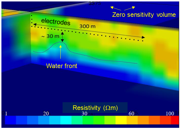
Artificial general intelligence (AGI), or strong AI, aims to replicate human-like cognitive abilities across diverse tasks and domains, demonstrating adaptability and learning like human intelligence. In contrast, weak AI refers to systems designed for specific tasks, lacking the broad cognitive flexibility of AGI. This paper introduces a novel approach to optimize oil production by integrating fundamental principles of AGI with geophysical data inversion and continuous monitoring techniques. Specifically, the study explored how AGI-inspired algorithms, combined with established reinforcement learning (RL) techniques, can enhance borehole electric/electromagnetic monitoring and reservoir fluid mapping technology. This integration aims to mitigate the risk of unwanted water invasion in production wells while optimizing oil extraction. The proposed methodology leverages real-time geophysical data analysis and automated regulation of oil production. The paper begins by outlining the key features of AGI and RL, and then discusses their application in electric/electromagnetic monitoring to define optimal production policies. The effectiveness of this approach was verified through synthetic tests, showing significant improvements in production efficiency, resource recovery, and environmental impact reduction.
Citation: Paolo Dell'Aversana. Reservoir geophysical monitoring supported by artificial general intelligence and Q-Learning for oil production optimization[J]. AIMS Geosciences, 2024, 10(3): 641-661. doi: 10.3934/geosci.2024033
Artificial general intelligence (AGI), or strong AI, aims to replicate human-like cognitive abilities across diverse tasks and domains, demonstrating adaptability and learning like human intelligence. In contrast, weak AI refers to systems designed for specific tasks, lacking the broad cognitive flexibility of AGI. This paper introduces a novel approach to optimize oil production by integrating fundamental principles of AGI with geophysical data inversion and continuous monitoring techniques. Specifically, the study explored how AGI-inspired algorithms, combined with established reinforcement learning (RL) techniques, can enhance borehole electric/electromagnetic monitoring and reservoir fluid mapping technology. This integration aims to mitigate the risk of unwanted water invasion in production wells while optimizing oil extraction. The proposed methodology leverages real-time geophysical data analysis and automated regulation of oil production. The paper begins by outlining the key features of AGI and RL, and then discusses their application in electric/electromagnetic monitoring to define optimal production policies. The effectiveness of this approach was verified through synthetic tests, showing significant improvements in production efficiency, resource recovery, and environmental impact reduction.

| [1] | Wang P, Goertzel B (2007) Introduction: Aspects of Artificial General Intelligence. Artificial General Intelligence: Concepts, Architectures and Algorithms. IOS Press, 1–16. |
| [2] | Goertzel B, Pennachin C (2007) Artificial General Intelligence, Springer Science and Business Media. |
| [3] | Goertzel B (2021) The General Theory of General Intelligence: A Pragmatic Patternist Perspective. arXiv: 2103.15100. |
| [4] | Franz A, Gogulya V, Löffler MW (2019) William: A monolithic approach to agi. International Conference on Artificial General Intelligence, Springer International Publishing, 44–58. |
| [5] | Franz A (2015) Artificial general intelligence through recursive data compression and grounded reasoning: a position paper. arXiv preprint arXiv: 1506.04366. |
| [6] | Al-Sikaiti SH, Regtien J (2008) Challenging Conventional Wisdom, Waterflooding Experience on Heavy Oil Fields in Southern Oman. Canada. |
| [7] |
Chierici GL, Ciucci GM, Pizzi G (1964) A Systematic Study of Gas and Water Coning By Potentiometric Models. J Pet Technol 16: 923–929. http://dx.doi.org/10.2118/871-PA doi: 10.2118/871-PA

|
| [8] | Chaperon I (1986) Theoretical Study of Coning Toward Horizontal and Vertical Wells in Anisotropic Formations: Subcritical and Critical Rates. SPE Annual Technical Conference and Exhibition. https://doi.org/10.2118/15377-MS |
| [9] | Wheatley MJ (1985) An Approximate Theory of Oil/Water Coning. SPE Annual Technical Conference and Exhibition, USA. https://doi.org/10.2118/14210-MS |
| [10] |
Karami M, Khaksar Manshad A, Ashoori S (2014) The Prediction of Water Breakthrough Time and Critical Rate with a New Equation for an Iranian Oil Field. Pet Sci Technol 32: 211–216. https://doi.org/10.1080/10916466.2011.586960 doi: 10.1080/10916466.2011.586960
|
| [11] | Bottazzi F, Dell'Aversana P, Molaschi C, et al. (2020) A New Downhole System for Real Time Reservoir Fluid Distribution Mapping: E-REMM, the Eni-Reservoir Electro-Magnetic Mapping System. International Petroleum Technology Conference. https://doi.org/10.2523/IPTC-19807-MS |
| [12] | Dell'Aversana P, Servodio R, Bottazzi F, et al., (2019) Asset Value Maximization through a Novel Well Completion System for 3d Time Lapse Electromagnetic Tomography Supported by Machine Learning. Abu Dhabi International Petroleum Exhibition & Conference. https://doi.org/10.2118/197573-MS |
| [13] | Dell'Aversana P, Rizzo E, Servodio R (2017) 4D borehole electric tomography for hydrocarbon reservoir monitoring. 79th EAGE Conference & Exhibition 2017. European Association of Geoscientists & Engineers. 1–5. |
| [14] | Dell'Aversana P, Bottazzi F, Molaschi C, et al. (2022) Monitoring and mapping system of the space-time distribution of formation fluids in a reservoir and a completion and production plant of a well for the extraction of formation fluids. U.S. Patent 11,268,374. |
| [15] |
Chella A, Frixione M, Gaglio S (2008) A cognitive architecture for robot self-consciousness. Artif Intell Med 44: 147–154. https://doi.org/10.1016/j.artmed.2008.07.003 doi: 10.1016/j.artmed.2008.07.003
|
| [16] |
Dehaene S, Lau H, Kouider S (2017) What is consciousness, and could machines have it? Science 358: 486–492. https://doi.org/10.1126/science.aan8871 doi: 10.1126/science.aan8871
|
| [17] |
Dell'Aversana P (2024) Enhancing Deep Learning and Computer Image Analysis in Petrography through Artificial Self-Awareness Mechanisms. Minerals 14: 247. https://doi.org/10.3390/min14030247 doi: 10.3390/min14030247
|
| [18] |
Um ES, Alumbaugh D, Commer M, et al. (2024) Deep learning multiphysics network for imaging CO2 saturation and estimating uncertainty in geological carbon storage. Geophys Prospect 72: 183–198. https://doi.org/10.1111/1365-2478.13257 doi: 10.1111/1365-2478.13257
|
| [19] |
Bergmann P, Schmidt-Hattenberger C, Kiessling D, et al. (2012) Surface-downhole electrical resistivity tomography applied to monitoring of CO2 storage at Ketzin, Germany. Geophysics 77: B253–B267. https://doi.org/10.1190/GEO2011-0515.1 doi: 10.1190/GEO2011-0515.1
|
| [20] |
Bergmann P, Schmidt-Hattenberger C, Labitzke T, et al. (2017) Fluid injection monitoring using electrical resistivity tomography—five years of CO2 injection at Ketzin, Germany. Geophys Prospect 65: 859–875. https://doi.org/10.1111/1365-2478.12426 doi: 10.1111/1365-2478.12426
|
| [21] |
Binley A (2015) Tools and Techniques: DC Electrical Methods. Treatise Geophys 11: 233–259. https://doi.org/10.1016/B978-0-444-53802-4.00192-5 doi: 10.1016/B978-0-444-53802-4.00192-5
|
| [22] | Binley A, Kemna A (2005) DC Resistivity and Induced Polarization Methods, In: Rubin Y, Hubbard SS, Authors, Hydrogeophysics, Springer, 129–156. |
| [23] |
Buscheck TA, White JA, Chen M, et al. (2014) Pre-injection brine production for managing pressure in compartmentalized CO2 storage reservoirs. Energy Procedia 63: 5333–5340. https://doi.org/10.1016/j.egypro.2014.11.565 doi: 10.1016/j.egypro.2014.11.565
|
| [24] |
Christensen NB, Sherlock D, Dodds K (2006) Monitoring CO2 injection with cross-hole electrical resistivity tomography. Explor Geophys 37: 44–49. https://doi.org/10.1071/EG06044 doi: 10.1071/EG06044
|
| [25] |
Descloitres M, Ribolzi O, Le Troquer Y (2003) Study of infiltration in a Sahelian gully erosion area using time-lapse resistivity mapping. Catena 53: 229–253. https://doi.org/10.1016/S0341-8162(03)00038-9 doi: 10.1016/S0341-8162(03)00038-9
|
| [26] | Goldman M, Kafri U (2006) Hydrogeophysical applications in coastal aquifers. Applied Hydrogeophysics, Springer: Dordrecht, 71: 233–254. https://doi.org/10.1007/978-1-4020-4912-5_8 |
| [27] |
Schmidt-Hattenberger C, Bergmann P, Bösing D, et al. (2013) Electrical resistivity tomography (ERT) for monitoring of CO2 migration—from tool development to reservoir surveillance at the Ketzinpilot site. Energy Procedia 37: 4268–4275. https://doi.org/10.1016/j.egypro.2013.06.329 doi: 10.1016/j.egypro.2013.06.329
|
| [28] |
Kazakis N, Pavlou A, Vargemezis G, et al. (2016) Seawater intrusion mapping using electrical resistivity tomography and hydrochemical data. An application in the coastal area of eastern Thermaikos Gulf, Greece. Sci Total Environ 543: 373–387. https://doi.org/10.1016/j.scitotenv.2015.11.041 doi: 10.1016/j.scitotenv.2015.11.041
|
| [29] | Tarrahi M, Afra S (2015) Optimization of Geological Carbon Sequestration in Heterogeneous Saline Aquifers through Managed Injection for Uniform CO2 Distribution. Carbon Management Technology Conference. https://doi.org/10.7122/440233-MS |
| [30] | Befus KM (2018) Pyres: A Python Wrapper for Electrical Resistivity Modeling with R2. J Geophys Eng 15: 338–346. |
| [31] | Binley A (2016) R2 version 3.1 Manual. Lancaster, UK. |
| [32] |
Dell'Aversana P (2021) Reservoir prescriptive management combining electric resistivity tomography and machine learning. AIMS Geosci 7: 138–161. https://doi.org/10.3934/geosci.2021009 doi: 10.3934/geosci.2021009
|
| [33] |
Kaelbling LP, Littman ML, Moore AW (1996) Reinforcement Learning: A Survey. J Artif Intell Res 4: 237–285. https://doi.org/10.1613/jair.301 doi: 10.1613/jair.301
|
| [34] | Raschka S, Mirjalili V (2017) Python Machine Learning: Machine Learning and Deep Learning with Python, scikit-learn, and TensorFlow, 2nd Eds., PACKT Books. |
| [35] | Ribeiro C, Szepesvári C (1996) Q-learning combined with spreading: Convergence and results, Proceedings of the ISRF-IEE International Conference: Intelligent and Cognitive Systems (Neural Networks Symposium), 32–36. |
| [36] | Russell S, Norvig P (2016) Artificial Intelligence: A Modern approach, Global Edition, Pearson Education, Inc., publishing as Prentice Hall. |
| [37] | Ravichandiran S (2020) Deep Reinforcement Learning with Python: Master classic RL, deep RL, distributional RL, inverse RL, and more with OpenAI Gym and TensorFlow, Packt Publishing. |
| [38] |
Ullah J, Li H, Ashraf U, et al. (2023) Knowledge-based machine learning for mineral classification in a complex tectonic regime of Yingxiu-Beichuan fault zone, Sichuan basin. Geoenergy Sci Eng 229: 212077. https://doi.org/10.1016/j.geoen.2023.212077 doi: 10.1016/j.geoen.2023.212077
|
| [39] |
Ullah J, Luo M, Ashraf U, et al. (2022) Evaluation of the geothermal parameters to decipher the thermal structure of the upper crust of the Longmenshan fault zone derived from borehole data. Geothermics 98: 102268. https://doi.org/10.1016/j.geothermics.2021.102268 doi: 10.1016/j.geothermics.2021.102268
|
| [40] |
Ullah J, Li H, Soupios P, et al. (2024) Optimizing geothermal reservoir modeling: A unified bayesian PSO and BiGRU approach for precise history matching under uncertainty. Geothermics 119: 102958. https://doi.org/10.1016/j.geothermics.2024.102958 doi: 10.1016/j.geothermics.2024.102958
|
| [41] | Eppelbaum LV, Zheludev V, Averbuch A (2014) Diffusion maps as a powerful tool for integrated geophysical field analysis to detecting hidden karst terranes. Izv Acad Sci Azerb Rep Ser.: Earth Sciences 2014: 36–46. |


Figures(9)

Paolo Dell'Aversana. Reservoir geophysical monitoring supported by artificial general intelligence and Q-Learning for oil production optimization[J]. AIMS Geosciences, 2024, 10(3): 641-661. doi: 10.3934/geosci.2024033


 DownLoad: