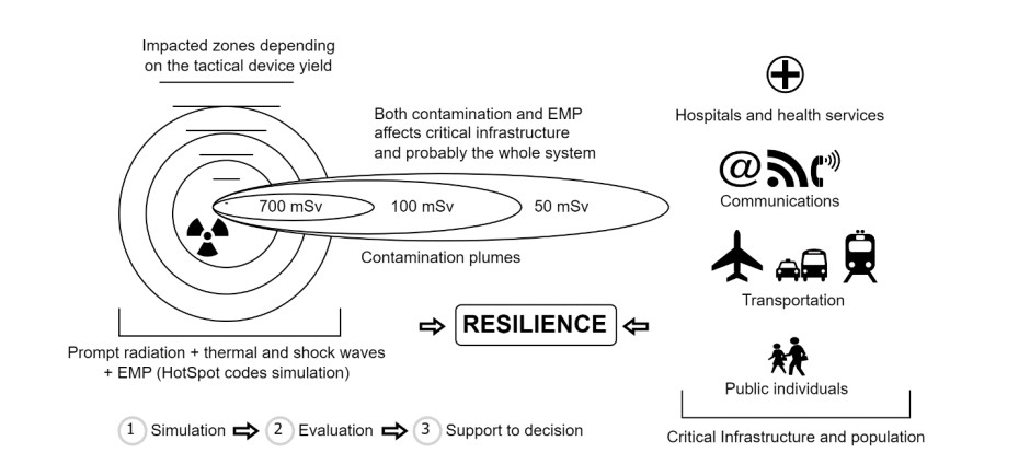
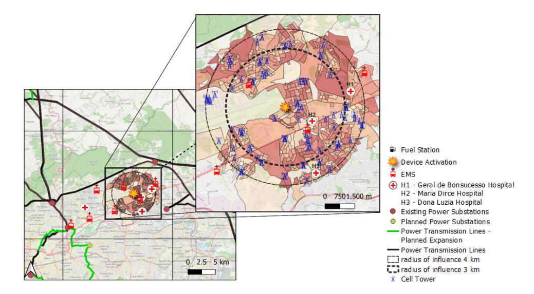
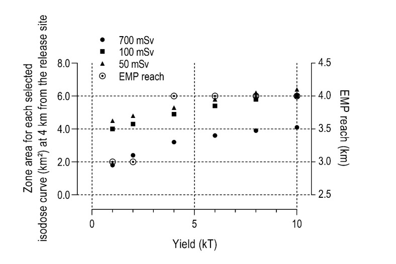
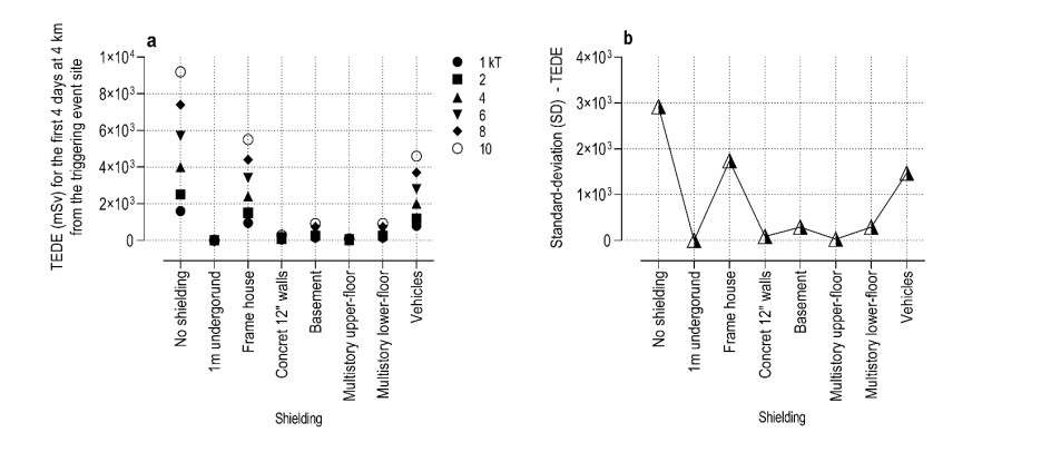
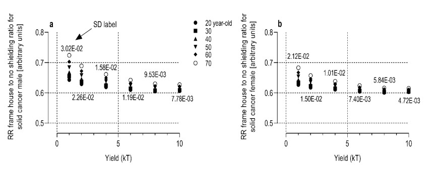
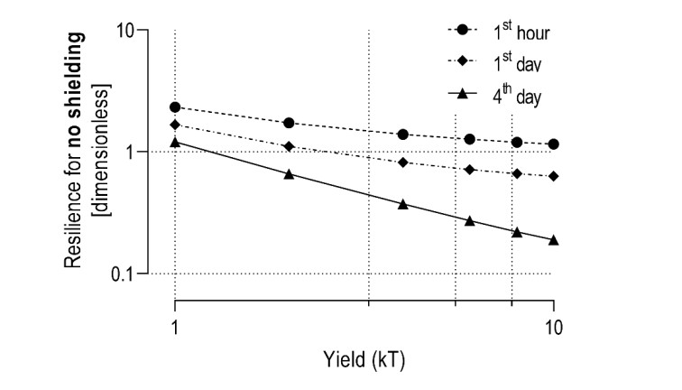
In the event of a hypothetical tactical nuclear device being detonated in a densely populated urban area, the first responders must be well-prepared to make immediate decisions with limited information. To aid in this preparation, a computer simulation using the HotSpot Health Physics code was conducted to model the detonation of a tactical nuclear device in an international airport and its surroundings, considering different yields ranging from 1 to 10 kilotons. The simulation was conservative and applied to a time window of 4 days in the initial phase of the response to the event. The simulation findings allow for assessing the immediate effects of the electromagnetic pulse (EMP) and the radioactive contamination plumes on an inhabited area. This assessment includes data on the size of impacted zones, compromise of critical local infrastructure, radiological risk to potentially affected populations, and estimation of urban resilience and its temporal dynamics. This information helps raise levels of protection and optimize available resources.
Citation: William H S Profeta, Rocco Pascale Neto, Vitor W L Silva, Carlos Eduardo S Bonfim, Rodrigo C Curzio, Ricardo M Stenders, Ubiratan C Oliveira, Raquel A A Costa e Oliveira, Claudio A Federico, Edson R Andrade. Short-term urban resilience estimation after a hypothetical nuclear event[J]. AIMS Geosciences, 2024, 10(1): 126-140. doi: 10.3934/geosci.2024008
In the event of a hypothetical tactical nuclear device being detonated in a densely populated urban area, the first responders must be well-prepared to make immediate decisions with limited information. To aid in this preparation, a computer simulation using the HotSpot Health Physics code was conducted to model the detonation of a tactical nuclear device in an international airport and its surroundings, considering different yields ranging from 1 to 10 kilotons. The simulation was conservative and applied to a time window of 4 days in the initial phase of the response to the event. The simulation findings allow for assessing the immediate effects of the electromagnetic pulse (EMP) and the radioactive contamination plumes on an inhabited area. This assessment includes data on the size of impacted zones, compromise of critical local infrastructure, radiological risk to potentially affected populations, and estimation of urban resilience and its temporal dynamics. This information helps raise levels of protection and optimize available resources.

| [1] |
Cohen AB, Trentalange M, Fried T (2015) Surrogate Decision Making for Patients Without Nuclear Family. JAMA 314: 407–408. https://doi.org/10.1001/jama.2015.7245 doi: 10.1001/jama.2015.7245

|
| [2] |
Mlakar P, Boznar MZ, Grasic B, et al. (2019) Integrated system for population dose calculation and decision making on protection measures in case of an accident with air emissions in a nuclear power plant. Sci Total Environ 666: 786–800. https://doi.org/10.1016/j.scitotenv.2019.02.309 doi: 10.1016/j.scitotenv.2019.02.309
|
| [3] | DOE (2003) Estimating Radiation Risk from Total Effective Dose Equivalent (TEDE)—ISCORS Technical Report. Office of Environmental Policy and Guidance. https://doi.org/10.2172/1374991 |
| [4] | Boyd M, Nelson C (2020) Standardized Radiogenic Cancer Risk Coefficients: a review of the Methodology Presented in Federal Guidance Report No. 13. |
| [5] | Takahara S, Iijima M, Watanabe M (2020) Assessment Model of Radiation Doses from External Exposure to the Public after the Fukushima Daiichi Nuclear Power Plant Accident. Health Phys 118: 664–677. |
| [6] | CISA A (2019) A Guide to Critical Infrastructure Security and Resilience. |
| [7] |
Coleman CN, Bader JL, Koerner JF, et al. (2019) Chemical, Biological, Radiological, Nuclear, and Explosive (CBRNE) Science and the CBRNE Science Medical Operations Science Support Expert (CMOSSE). Disaster Med Public 13: 995–1010. https://doi.org/10.1017/dmp.2018.163 doi: 10.1017/dmp.2018.163
|
| [8] |
Andrade ER, Reis ALQ, Alves DF, et al. (2020) Urban critical infrastructure disruption after a radiological dispersive device event. J Environ Radioact 222: 106358. https://doi.org/10.1016/j.jenvrad.2020.106358 doi: 10.1016/j.jenvrad.2020.106358
|
| [9] | Andrade ER, Reis ALQ, Stenders RM, et al. (2022) Evaluating urban resilience in a disruptive radioactive event. Prog Nucl Energy 147: 104218. |
| [10] |
Cheng S, Prentice IC, Huang Y, et al. (2022) Data-driven surrogate model with latent data assimilation: Application to wildfire forecasting. J Comput Phys 464: 111302. https://doi.org/10.1016/j.jcp.2022.111302 doi: 10.1016/j.jcp.2022.111302
|
| [11] |
Cheng S, Argaud JP, Iooss B, et al. (2021) Error covariance tuning in variational data assimilation: application to an operating hydrological model. Stoch Environ Res Risk Assess 35: 1019–1038. https://doi.org/10.1007/s00477-020-01933-7 doi: 10.1007/s00477-020-01933-7
|
| [12] | Glasstone S, Dolan PJ (1977) The Effects of Nuclear Weapons. Third edition. United States. Medium: ED, 660. |
| [13] | Drumm CR, Fan WC (2017) Efficient Modeling of System Generated Electromagnetic Pulse using Adjoint Methods. The 35th Hardened Electronics and Radiation Technology (HEART) Technical Interchange Meeting, Tucson, United State, 4. |
| [14] | Pasquill F (1961) The estimation of the dispersion of windborne material. Metero Mag 90: 33–491. |
| [15] | Thaul S OMH (1999) Potential Radiation Exposure in Military Operations: Protecting the Soldier Before, During, and After. https://doi.org/10.17226/9454 |
| [16] | Barabanova A, Wakeford R (1996) Methods for Estimating the Probability of Cancer from Occupational Radiation Exposure. International Atomic Energy Agency. |
| [17] | Homann SG (2020) HotSpot Health Physics Codes Version 3.1.2 User's Guide. Lawrence Livermore National Laboratory. |
| [18] | Valentin J (2007) The 2007 Recommendations of the International Commission on Radiological Protection, Elsevier, 1–332. |
| [19] |
Pawlak G, Płochocki P, Simiński P, et al. (2022) Emergency fueling unit for means of heavy transport affected by electromagnetic pulse. Sci Rep 12: 2115. https://doi.org/10.1038/s41598-022-06087-w doi: 10.1038/s41598-022-06087-w
|
Figures(6)

William H S Profeta, Rocco Pascale Neto, Vitor W L Silva, Carlos Eduardo S Bonfim, Rodrigo C Curzio, Ricardo M Stenders, Ubiratan C Oliveira, Raquel A A Costa e Oliveira, Claudio A Federico, Edson R Andrade. Short-term urban resilience estimation after a hypothetical nuclear event[J]. AIMS Geosciences, 2024, 10(1): 126-140. doi: 10.3934/geosci.2024008


 DownLoad: