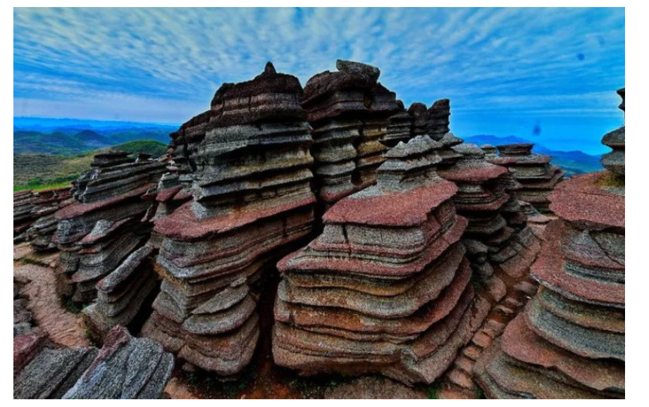
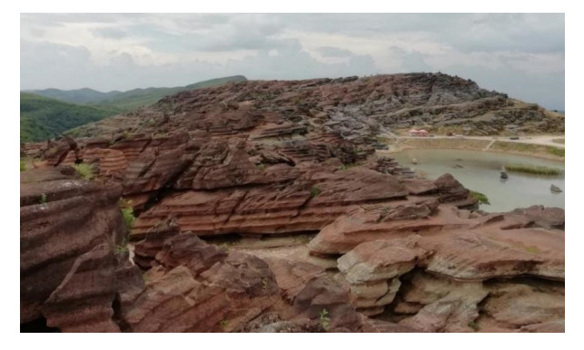
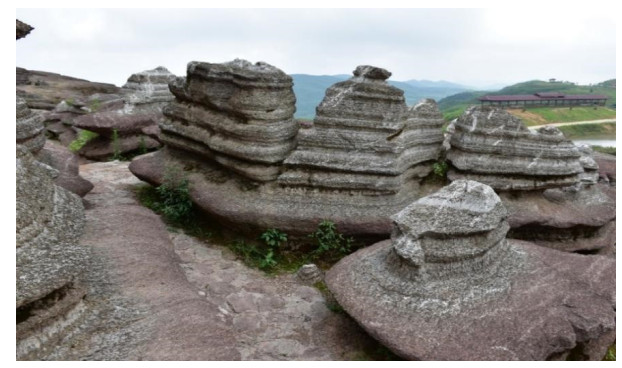
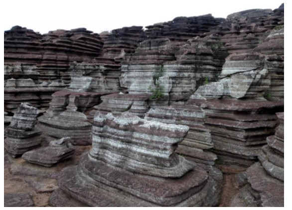
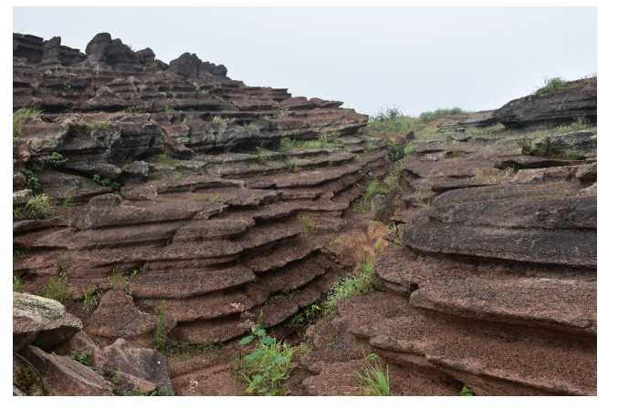
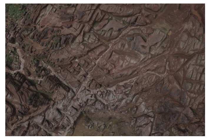
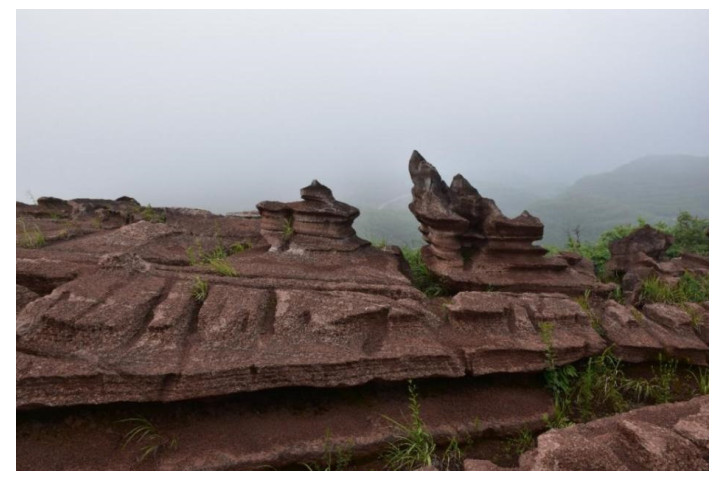
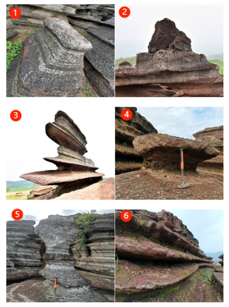
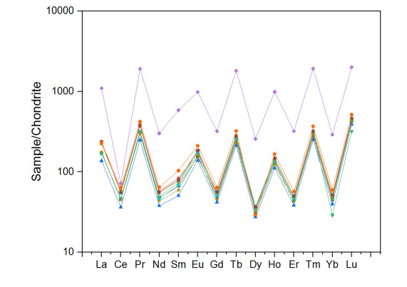
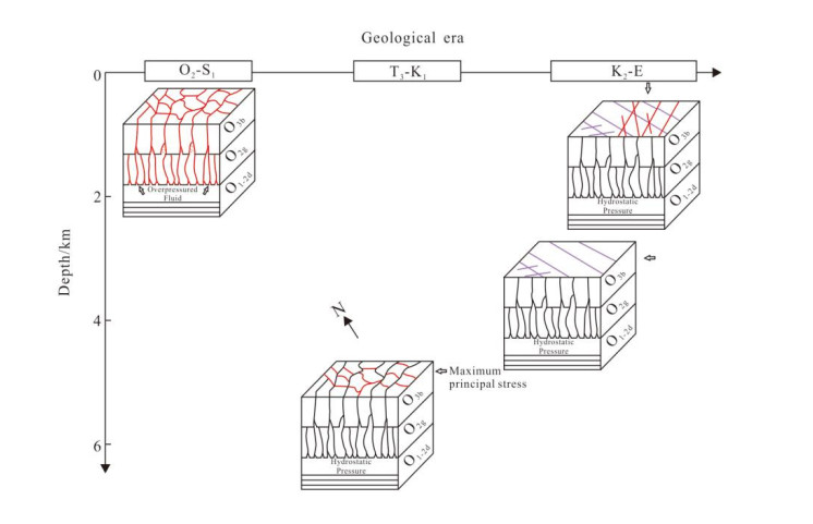
China is rich in karst resources and famous for its karst landscape. As a part of karst, the popularity of red karst is obviously low and has received little attention; moreover, the related scientific research and tourism development are relatively immature. Therefore, this paper takes the red karst in Tongren, Guizhou as the research object, analyzes the characteristics and causes of the red karst, comprehensively evaluates its landscape value, and puts forward development strategies and protection suggestions. Through the above research, the following three research results are obtained. (1) On the basis of a field investigation and a literature review, the geographical situation, background, and landscape characteristics of the red karst landform and its surrounding areas in Tongren City were investigated in detail. It forms isolated peaks, rock walls, protruding rocks, stone pillars, and other forms. The most prominent features of the red karst landscape in Tongren City are that the color is red and white, and the shape is concave and convex in order. (2) Geochemical test and structural data collection and analyses of the collected samples were performed. The obtain concave layer rock is dolomitic limestone, and that convex lay rock is argillaceous dolomitic limestone. Because the convex layer rock sample is high in silicon element content, the convex layer rock sample is not easy to be weathered, is rich in clay mineral, and is not easy to be corrode; the convex layer rock sample gradually protrudes with the passage of time to form an uneven shape. The red karst landform is developed in either the rock stratum or tectonic zone with moderate tectonic deformation intensity. First, the formation of a single-layer honeycomb morphology requires that the rock stratum is subjected to a sufficient horizontal compressive stress at a certain burial depth. Second, it is necessary to widely exist in areas with relatively gentle rock formation occurrence; too strong of a structural deformation will make the rock formation occurrence steep, which is not conducive to the occurrence of differential dissolution between adjacent strata. (3) Through the construction of an evaluation index system, the red karst in Tongren City is evaluated, and it is concluded that the geological heritage value is high, and the development and utilization conditions are weak. The conclusion of this article is a supplement to the geological and geomorphological system characteristics of southern karst. From the perspective of world natural heritage, the study enriches the academic evidence of red karst and enables its exemplary role to be well played. From the perspective of the tourism development value, more people should be made aware of the diverse types of karst landforms, which provide experience and suggestions for the value of landforms, tourism resources, and tourism development in similar areas.
Citation: Wu Yang, Ning Yu, Mingxing Yang, Jun Yan, Min Zhang, ShiQiang Yang. Sustainable development of geological resources: the Characteristics of Red Karst Landscape and Tourism Development in Tongren, Guizhou[J]. AIMS Geosciences, 2024, 10(1): 141-171. doi: 10.3934/geosci.2024009
China is rich in karst resources and famous for its karst landscape. As a part of karst, the popularity of red karst is obviously low and has received little attention; moreover, the related scientific research and tourism development are relatively immature. Therefore, this paper takes the red karst in Tongren, Guizhou as the research object, analyzes the characteristics and causes of the red karst, comprehensively evaluates its landscape value, and puts forward development strategies and protection suggestions. Through the above research, the following three research results are obtained. (1) On the basis of a field investigation and a literature review, the geographical situation, background, and landscape characteristics of the red karst landform and its surrounding areas in Tongren City were investigated in detail. It forms isolated peaks, rock walls, protruding rocks, stone pillars, and other forms. The most prominent features of the red karst landscape in Tongren City are that the color is red and white, and the shape is concave and convex in order. (2) Geochemical test and structural data collection and analyses of the collected samples were performed. The obtain concave layer rock is dolomitic limestone, and that convex lay rock is argillaceous dolomitic limestone. Because the convex layer rock sample is high in silicon element content, the convex layer rock sample is not easy to be weathered, is rich in clay mineral, and is not easy to be corrode; the convex layer rock sample gradually protrudes with the passage of time to form an uneven shape. The red karst landform is developed in either the rock stratum or tectonic zone with moderate tectonic deformation intensity. First, the formation of a single-layer honeycomb morphology requires that the rock stratum is subjected to a sufficient horizontal compressive stress at a certain burial depth. Second, it is necessary to widely exist in areas with relatively gentle rock formation occurrence; too strong of a structural deformation will make the rock formation occurrence steep, which is not conducive to the occurrence of differential dissolution between adjacent strata. (3) Through the construction of an evaluation index system, the red karst in Tongren City is evaluated, and it is concluded that the geological heritage value is high, and the development and utilization conditions are weak. The conclusion of this article is a supplement to the geological and geomorphological system characteristics of southern karst. From the perspective of world natural heritage, the study enriches the academic evidence of red karst and enables its exemplary role to be well played. From the perspective of the tourism development value, more people should be made aware of the diverse types of karst landforms, which provide experience and suggestions for the value of landforms, tourism resources, and tourism development in similar areas.

| [1] | Yuan DX (1993) Carbon cycle and global karst. Quaternary Sciences, 1–6. |
| [2] | Guizhou DST (Guizhou Provincial Department of Science and Technology) (2021) Karst promotional materials. Available from: http://kjt.guizhou.gov.cn/zwgk/kpgz/kjhdz/202108/t20210830_69811278.html. |
| [3] | Zhao Xun (2010) Research on karst geomorphology in Fangshan, China. Beijing: Geological Publishing House. |
| [4] | Li D, Luo Y (1983) Measurement of the distribution area of carbonate rocks in China. Carsol Sin 2: 61–64. |
| [5] | Jiang F, Dong Y, Chen Y (2020) Characteristics and genesis of red karst in Guizhou section of Youshui basin. Carsol Sin 39: 937–944. |
| [6] | Zeng Z, Huang S (1978) Red bed landform in southeast China. J South China Norm Univ 1: 56–73. |
| [7] |
Li Z, Yang Z, Wang S, et al. (2024) The Effects of Coal Floor Brittleness on the Risk of Water Inrushes from Underlying Aquifers: A Numerical Study. Sustainability 16: 1489. https://doi.org/10.3390/su16041489 doi: 10.3390/su16041489

|
| [8] | Guo F (2007) Environmental functional characteristics and formation mechanism of karst cave interaction zone. Xi'an: Chang'an University. |
| [9] |
Chi Y, He C (2023) Impact of Land Use Change on the Spatial and Temporal Evolution of Ecosystem Service Values in South China Karst Areas. Forests 14: 893. https://doi.org/10.3390/f14050893 doi: 10.3390/f14050893
|
| [10] |
Jones B, Manning AC (1994) Comparison of geochemical indices used for the interpretation of palaeoredox conditions in ancient mudstones. Chem Geol 111: 111–129. https://doi.org/10.1016/0009-2541(94)90085-X doi: 10.1016/0009-2541(94)90085-X
|
| [11] |
Cai Y, Wu F, Han J, et al. (2019) Geoheritage and Sustainable Development in Yimengshan Geopark. Geoheritage 11: 991–1003. https://doi.org/10.1007/s12371-019-00348-3 doi: 10.1007/s12371-019-00348-3
|
| [12] |
Herrera-Franco G, Carrión-Mero P, Alvarado N, et al. (2020) Geosites and Georesources to Foster Geotourism in Communities: Case Study of the Santa Elena Peninsula Geopark Project in Ecuador. Sustainability 12: 4484. https://doi.org/10.3390/su12114484 doi: 10.3390/su12114484
|
| [13] |
Kubalíková L (2019) Assessing Geotourism Resources on a Local Level: A Case Study from Southern Moravia (Czech Republic). Resources 8: 150. https://doi.org/10.3390/resources8030150 doi: 10.3390/resources8030150
|
| [14] |
Özgeriş M, Karahan F (2021) Use of geopark resource values for a sustainable tourism: A case study from Turkey (Cittaslow Uzundere). Environ Dev Sustain 23: 4270–4284. https://doi.org/10.1007/s10668-020-00773-3 doi: 10.1007/s10668-020-00773-3
|
| [15] |
Vu HD, Nguyen NTP, Ngo YTH, et al. (2022) GEOTOURISM CURRENT STATE AND FUTURE PROSPECTS: A CASE STUDY IN THE CAO BANG UNESCO GLOBAL GEOPARK, VIETNAM. GeoJournal Tour Geosites 43: 1063–1070. https://doi.org/10.30892/gtg.43327-921 doi: 10.30892/gtg.43327-921
|
| [16] |
Weihrich H (1982) The TOWS matrixâ—A tool for situational analysis. Long Range Plan 15: 54–66. https://doi.org/10.1016/0024-6301(82)90120-0 doi: 10.1016/0024-6301(82)90120-0
|
| [17] | Peng S (2014) Global Standard Stratotype-section and Point (GSSP, "Golden Spike") and the GSSP research in China. Earth Sci Front 21: 8–26. |
| [18] | Zhao J (2014) Lithofacies Paleogeography of the Middle Ordovician in the Middle and Upper Yangtze Region. Master Dissertation of Yangtze University, 38–58. |
| [19] |
Chen Y, Jiang F, Yu N, et al. (2023) Geological conditions and genetic analysis of the formation of red karst landform in Hunan, Chongqing and Guizhou. Geochemistry 52: 94–104. https://doi.org/10.19700/j.0379-1726.2021.04.009 doi: 10.19700/j.0379-1726.2021.04.009
|
| [20] | Jiang F, Dong Y, Chen Y, et al. (2020) Characteristics and genesis of red karst in the Guizhou section of the Youshui Basin. Karst China 39: 937–944. |
| [21] | Cui Z, Li D, Liu G, et al. (2001) The nature of red karst weathering crust and the formation environment of planation plane in Hunan, Guangxi, Guizhou, Yunnan and Tibet. Chin Sci (Part D: Earth Sci) S1: 134–141. |
| [22] | Ye Q (2020) Xiangxi UNESCO Global Geopark: Cambrian Golden Spike and karst wonders. Earth 9: 6–13. |
| [23] | Wu L, Chen W, Rong Y, et al. (2020) Development characteristics and research value of red carbonate stone forest in the Xiangxi geopark. Carsologica Sin 39: 251–258. |
| [24] | Jiang F, Dong Y, Su X, et al. (2020) Preliminary dicussion on the concept of red karst and its scientific value. Carsologica Sin 39: 775–780. |
| [25] | Jiang Z, Zhang J, Huang C, et al. (2019) Causes of formation and geo-scientific significance of karst gorge geoup in Xiangxi geopark. Carsologica Sin 38: 269–275. |
| [26] |
Venturini C, Pasquaré Mariotto F (2019) Geoheritage Promotion Through an Interactive Exhibition: A Case Study from the Carnic Alps, NE Italy. Geoheritage 11: 459–469. https://doi.org/10.1007/s12371-018-0299-7 doi: 10.1007/s12371-018-0299-7
|
| [27] |
Zouros N, Pavlides S, Soulakellis N, et al. (2011) Using Active Fault Studies for Raising Public Awareness and Sensitisation on Seismic Hazard: A Case Study from Lesvos Petrified Forest Geopark, NE Aegean Sea, Greece. Geoheritage 3: 317–327. https://doi.org/10.1007/s12371-011-0044-y doi: 10.1007/s12371-011-0044-y
|
| [28] |
Antić A, Tomić N, Đorđević T, et al. (2021) Promoting Palaeontological Heritage of Mammoths in Serbia Through a Cross-Country Thematic Route. Geoheritage 13: 7. https://doi.org/10.1007/s12371-021-00530-6 doi: 10.1007/s12371-021-00530-6
|
| [29] |
Tomić N, Marković SB, Korać M, et al. (2015). Exposing mammoths: From loess research discovery to public palaeontological park. Quat Int 372: 142–150. https://doi.org/10.1016/j.quaint.2014.12.026 doi: 10.1016/j.quaint.2014.12.026
|
| [30] |
Yang W, Min Z, Yang M, et al. (2020) Exploration of the Implementation of Carbon Neutralization in the Field of Natural Resources under the Background of Sustainable Development—An Overview. Int J Environ Res Public Health 19: 14109. https://doi.org/10.3390/ijerph192114109 doi: 10.3390/ijerph192114109
|
| [31] |
Mirari S, Aoulad-Sidi-Mhend A, Benmlih A (2020) Geosites for Geotourism, Geoheritage, and Geoconservation of the Khnefiss National Park, Southern Morocco. Sustainability 12: 7109. https://doi.org/10.3390/su12177109 doi: 10.3390/su12177109
|
Figures(10) / Tables(4)

Wu Yang, Ning Yu, Mingxing Yang, Jun Yan, Min Zhang, ShiQiang Yang. Sustainable development of geological resources: the Characteristics of Red Karst Landscape and Tourism Development in Tongren, Guizhou[J]. AIMS Geosciences, 2024, 10(1): 141-171. doi: 10.3934/geosci.2024009


 DownLoad: