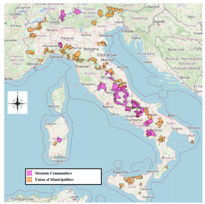
In recent months, the COVID-19 pandemic has been fervently considered from the perspective of various disciplines in the scientific community. Many of the proposed approaches are tied to reflections on the imminent and future effects of the pandemic. This contribution begins with a study of the recent past in Italy, analyzing the hurdles in politics that came to light due to the wave of COVID-19 infections worldwide. Particularly, the research considers the criticality of the geographical scale of reference in Italy's political actions. COVID-19 induced a need for the government to interact with people locally, especially through small municipalities in geographically central, inner areas, is emphasized. The main aim of this research is to attribute to this specific COVID-19 disaster the instrumental role of turning on the lights on the need to intervene in the inner areas of Italy, often very neglected. So the focus of the work is on inner areas and the probable catalysis of the political management dynamics that concern them, as an effect of the COVID's impacts. The pandemic is, therefore, only the contingent phenomenon which, in this case, can perhaps accelerate political interventions in inner areas. To explain the reason for this, we show how the vulnerability of inner areas, already generally risky, has become one of the weak links in the chain of protection from COVID-19 in terms of a geographical scattering phenomenon.
Citation: Stefano De Falco, Giulia Fiorentino. Geographical scattering in Italian inner areas, politics and COVID-19[J]. AIMS Geosciences, 2022, 8(1): 137-158. doi: 10.3934/geosci.2022009
In recent months, the COVID-19 pandemic has been fervently considered from the perspective of various disciplines in the scientific community. Many of the proposed approaches are tied to reflections on the imminent and future effects of the pandemic. This contribution begins with a study of the recent past in Italy, analyzing the hurdles in politics that came to light due to the wave of COVID-19 infections worldwide. Particularly, the research considers the criticality of the geographical scale of reference in Italy's political actions. COVID-19 induced a need for the government to interact with people locally, especially through small municipalities in geographically central, inner areas, is emphasized. The main aim of this research is to attribute to this specific COVID-19 disaster the instrumental role of turning on the lights on the need to intervene in the inner areas of Italy, often very neglected. So the focus of the work is on inner areas and the probable catalysis of the political management dynamics that concern them, as an effect of the COVID's impacts. The pandemic is, therefore, only the contingent phenomenon which, in this case, can perhaps accelerate political interventions in inner areas. To explain the reason for this, we show how the vulnerability of inner areas, already generally risky, has become one of the weak links in the chain of protection from COVID-19 in terms of a geographical scattering phenomenon.

| [1] |
Ferraresi M, Gucciardi G (2021) Political alignment, centralisation, and the sense of government unpreparedness during the COVID-19 pandemic. Eur J Polit Econ, 102144. https://doi.org/10.1016/j.ejpoleco.2021.102144 doi: 10.1016/j.ejpoleco.2021.102144

|
| [2] |
Coccia M (2020) Factors determining the diffusion of COVID-19 and suggested strategy to prevent future accelerated viral infectivity similar to COVID. Sci Total Environ 729: 1-20. https://doi.org/10.1016/j.scitotenv.2020.138474 doi: 10.1016/j.scitotenv.2020.138474
|
| [3] |
Coccia M (2021) Preparedness of countries to face COVID-19 pandemic crisis: Strategic positioning and underlying structural factors to support strategies of prevention of pandemic threats. Environ Res 203: 111678. https://doi.org/10.1016/j.envres.2021.111678 doi: 10.1016/j.envres.2021.111678
|
| [4] |
Xu K, Cui K, Young LH, et al. (2020) Impact of the COVID-19 Event on Air Quality in Central China. Aerosol Air Qual Res 20: 915-929. https://doi.org/10.4209/aaqr.2020.04.0150 doi: 10.4209/aaqr.2020.04.0150
|
| [5] |
Coccia M (2021) The impact of first and second wave of the COVID-19 pandemic: comparative analysis to support control measures to cope with negative effects of future infectious diseases in society. Environ Res 197: 111099. https://doi.org/10.1016/j.envres.2021.111099 doi: 10.1016/j.envres.2021.111099
|
| [6] |
Rosario DKA, Mutz YS, Bernardes PC, et al. (2020) Relationship between COVID-19 and weather: case study in a tropical country. Int J Hyg Environ Health 229: 113587. https://doi.org/10.1016/j.ijheh.2020.113587 doi: 10.1016/j.ijheh.2020.113587
|
| [7] | Coccia M (2021) Comparative Critical Decisions in Management. Global Encyclopedia of Public Administration, Public Policy, and Governance. Springer Nature, Cham. https://doi.org/10.1007/978-3-319-31816-5_3969-1 |
| [8] |
Askitas N, Tatsiramos K, Verheyden B (2021) Estimating worldwide effects of non-pharmaceutical interventions on COVID-19 incidence and population mobility patterns using a multiple—event study. Sci Rep 11: 1972. https://doi.org/10.1038/s41598-021-81442-x doi: 10.1038/s41598-021-81442-x
|
| [9] |
Coccia M (2020) Factors determining the diffusion of COVID-19 and suggested strategy to prevent future accelerated viral infectivity similar to COVID. Sci Total Environ 729: 138474. https://doi.org/10.1016/j.scitotenv.2020.138474 doi: 10.1016/j.scitotenv.2020.138474
|
| [10] |
Zhu Y, Xin J (2020) Association between ambient temperature and COVID-19 infection in 122 cities from China. Sci Total Environ 724: 138201. https://doi.org/10.1016/j.scitotenv.2020.138201 doi: 10.1016/j.scitotenv.2020.138201
|
| [11] |
Sarkodie SA, Owusu PA (2020) Impact of meteorological factors on COVID-19 pandemic: Evidence from top 20 countries with confirmed cases. Environ Res 191: 110101. https://doi.org/10.1016/j.envres.2020.110101 doi: 10.1016/j.envres.2020.110101
|
| [12] | Bashir MF, Bilal BM, Komal B (2020) Correlation between environmental pollution indicators and COVID-19 pandemic: A brief study in Californian context. Environ Res. 109652. https://doi.org/10.1016/j.envres.2020.109652 |
| [13] |
Srivastava A (2021) COVID-19 and air pollution and meteorology-an intricate relationship: A review. Chemosphere 263: 128297. https://doi.org/10.1016/j.chemosphere.2020.128297 doi: 10.1016/j.chemosphere.2020.128297
|
| [14] | Macchi JG, Palumbo A (2019) Introduction. Broken territories. Depopulation and abandonment in the inland areas of contemporary Italy, Rome, CISGE Italian Center for Historical-Geographical Studies. |
| [15] | Banini T, Impei F (2019) Geographies of territorial abandonment. Definitive and daily mobility in the Aniene Valley. Broken territories. Depopulation and abandonment in the inland areas of contemporary Italy, Rome, CISGE Italian Center for Historical-Geographical Studies. |
| [16] | Mai R, Bucher H (2005) Depopulation and its Consequences in the Regions of Europe, Brussels. Soc Cohes 3: 121-135. |
| [17] | Carr PJ, Kefalas MJ (2009) Hollowing out the middle: The rural brain drain and what it means for America, Beacon press. |
| [18] | Haase A, Rink D, Grossmann K, et al. (2014) The concept of urban shrinkage. Environ Plann A 46: 1519-1534. |
| [19] |
Turok I, Mykhnenko V (2007) The trajectories of European cities, 1960-2005. Cities 24: 165-182. https://doi.org/10.1016/j.cities.2007.01.007 doi: 10.1016/j.cities.2007.01.007
|
| [20] |
Hospers GJ (2014) Policy responses to urban shrinkage: Fromgrowth thinking to civic engagement. Eur Plann Stud 22: 1507-1523. https://doi.org/10.1080/09654313.2013.793655 doi: 10.1080/09654313.2013.793655
|
| [21] |
Rink D, Couch C, Haase A, et al. (2014) The governance of urban shrinkage in cities of post-socialist Europe: Policies strategies and actors. Urban Res Pract 7: 258-277. https://doi.org/10.1080/17535069.2014.966511 doi: 10.1080/17535069.2014.966511
|
| [22] |
Silverman RM (2018) Rethinking shrinking cities: Peripheral dual cities have arrived. J Urban Aff 42: 294-311. https://doi.org/10.1080/07352166.2018.1448226 doi: 10.1080/07352166.2018.1448226
|
| [23] |
Reynaud C, Miccoli S (2018) Depopulation and the Aging Population: The Relationship in Italian Municipalities. Sustainability 10: 1004-1028. https://doi.org/10.3390/su10041004 doi: 10.3390/su10041004
|
| [24] |
Coleman D, Rowthorn R (2011) Who's afraid of population decline? A critical examination of its consequences. Popul Dev Rev 37: 217-248. https://doi.org/10.1111/j.1728-4457.2011.00385.x doi: 10.1111/j.1728-4457.2011.00385.x
|
| [25] | Strozza S (2016) Foreign immigration in Italy: A forty-year-old history. In Proceedings of the 48th Scientific Meeting of the Italian Statistical Society Salerno Italy 8-10. |
| [26] |
Harper S (2016) The important role of migration for an aging nation. J Popul Aging 9: 183-189. https://doi.org/10.1007/s12062-016-9152-4 doi: 10.1007/s12062-016-9152-4
|
| [27] | Amato V, De Falco S (2019) Tourism enhancement and new digital technologies. The rural inland areas close to consolidated tourist circuits and the case of the small inland villages of Cilento. Ann Tourism Geoprogress, 47-61. |
| [28] | Figueiredo E (2009) One rural two visions—Environmental issues and images on rural areas in Portugal. Eur Countryside 1: 9-21. |
| [29] |
Phelan C, Sharpley R (2011) Exploring agritourism entrepreneurship in the UK. Tourism Plann Dev 8: 121-136. https://doi.org/10.1080/21568316.2011.573912 doi: 10.1080/21568316.2011.573912
|
| [30] |
Marsden T, Sonnino R (2008) Rural development and the regional state: Denying multifunctional agriculture in the UK. J Rural Stud 24: 422-431. https://doi.org/10.1016/j.jrurstud.2008.04.001 doi: 10.1016/j.jrurstud.2008.04.001
|
| [31] |
Kizos T, Vakoufaris H (2011) Valorisation of a local asset: The case of olive oil on Lesvos Island Greece. Food Policy 36: 705-714. https://doi.org/10.1016/j.foodpol.2011.06.005 doi: 10.1016/j.foodpol.2011.06.005
|
| [32] | Soja EW (2011) Regional Urbanization and the End of the Metropolis Era. The New Blackwell Companion to the City. Chichester: Wiley-Blackwell. https://doi.org/10.1002/9781444395105.ch59 |
| [33] |
Soja EW (2011) Beyond Postmetropolis. Urban Geogr 32: 451-469. https://doi.org/10.2747/0272-3638.32.4.451 doi: 10.2747/0272-3638.32.4.451
|
| [34] | Armillei F, Filippucci F (2020) The heterogenous impact of COVID-19. Evidence from Italian municipalities. Available on line: https://www.localopportunitieslab.it/wp-content/uploads/2020/08/The-heterogenous-impact-of-Covid19-Evidence-from-Italian-municipalities-Armillei-and-Filippucci.pdf |
| [35] |
Jonas AEG (2012) City-Regionalism as a Contingent 'Geopolitics of Capitalism'. Geopolitics 18: 284-298. https://doi.org/10.1080/14650045.2012.723290 doi: 10.1080/14650045.2012.723290
|
| [36] | Paasi A (2010) Regions are social constructs but who or what 'constructs' them? Agency in question. Environ Plann A 42: 2296-2301. |
| [37] | Conzen MP, Greene RP (2008) Chicago and Los Angeles: paradigms schools archetypes and the urban process. Urban Geogr 29: 97-186. |
| [38] | Balducci A, Fedeli VE, Curci F (2017) Post-Metropolitan Territories. Looking for a New Urbanity, London: Routledge. |
| [39] | De Falco S (2020) Scattering geografico nelle aree interne nella diffusione del COVID-19. Documnti Geografici, 141-154. http://dx.doi.org/10.19246/DOCUGEO2281-7549/202001_08 |
| [40] | NRC (2007) Successful Response Starts with a Map: Improving Geospatial Sup-port for Disaster Management, National Research Council. https://doi.org/10.17226/11793 |
| [41] | Reed M, Simon B (1979) Methods of modern mathematical physics. Scattering theory, New York: Academic Press Inc. |
| [42] |
Carrillo M, González J (2002) A new approach to modeling sigmoidal curves. Technol Forecast Soc Change 69: 233-224. https://doi.org/10.1016/S0040-1625(01)00150-0 doi: 10.1016/S0040-1625(01)00150-0
|
| [43] |
Berny J (1994) New concepts and applications in Growth Phenomena. J Appl Stat 21: 161-190. https://doi.org/10.1080/757583654 doi: 10.1080/757583654
|
| [44] | Bass FM (1969) A New Product Growth for Model Consumer Durables Management. Science 15: 215-227. |
| [45] | Webber MJ (1972) Impact of Uncertainty on location, Cambridge MA: MIT Press. |
| [46] |
Lawton SB (1979) An autocatalytic model for the diffusion of educational innovations. Educational Administration. Quarterly 15: 19-46. https://doi.org/10.1177/0013131X7901500103 doi: 10.1177/0013131X7901500103
|
| [47] |
Warren EH (1980) Solar energy market penetration models: science or number mysticism? Technol Forecast Soc Change 16: 105-118. https://doi.org/10.1016/0040-1625(80)90002-5 doi: 10.1016/0040-1625(80)90002-5
|
| [48] | Ciaschi A, Vincenti G (2019) Depopulation and abandonment in the inner areas of contemporary Italy, Territori Spezzati. Place and identity: two perspectives on abandonment, CISGE Italian Center for Historical-Geographical Studies Rome, 45-52. |
| [49] | Gasparini ML (2019) From abandonment to recovery: the prospects for the restoration of some inland areas of Campania affected by the earthquake of 1980, Territori Spezzati. Place and identity: two perspectives on abandonment, CISGE Italian Center for Historical-Geographical Studies Rome, 97-104. |
| [50] | Ferrari F (2017) Territorial capital and tourism in inner areas: theoretical reflections and methodological proposals. Proceedings of the XXXII Italian Geo-graphic Congress 2017 Rome. Available from: https://www.academia.edu/36144775/XXXII_CONGRESSO_GEOGRAFICO_ITALIANO_L_apporto_della_geografa_tra_rivoluzioni_e_riforme |
| [51] | Petino G (2017) The geo-economic analysis for the enhancement of the productive vocations of the Sicilian inner areas. The case of the Simeto Valley. Proceedings of the XXXII Italian Geographic Congress 2017 Rome. Available from: https://www.academia.edu/36144775/XXXII_CONGRESSO_GEOGRAFICO_ITALIANO_L_apporto_della_geografa_tra_rivoluzioni_e_riforme |
| [52] | Pettenati G (2016) Territorial projects: Italian landscapes in the Unesco World Heritage List. Riv Geogr Ital 123: 525-543. |
| [53] |
Ghosh JK, Biswas SK, Sarkar S, et al. (2022) Mathematical modelling of COVID-19: A case study of Italy. Math Comput Simul 194: 1-18. https://doi.org/10.1016/j.matcom.2021.11.008 doi: 10.1016/j.matcom.2021.11.008
|
| [54] |
Swianiewicz P (2021) From post-communist democratic laissez-faire to prevention of territorial fragmentation: tightening the rules of municipal splits in Central and Eastern Europe after 1990. Misc Geographica Reg Stud Dev 25: 5-17. https://doi.org/10.2478/mgrsd-2020-0046 doi: 10.2478/mgrsd-2020-0046
|
| [55] |
Saganeiti L, Pilogallo A, Scorza F, et al. (2018) Spatial Indicators to Evaluate Urban Fragmentation in Basilicata Region. Comput Sci Its Appl ICCSA 2018 10964: 100-112. https://doi.org/10.1007/978-3-319-95174-4_8 doi: 10.1007/978-3-319-95174-4_8
|
| [56] | Marchetti M, Panuzi S, Pazzagli R, (2017) Inner areas. For a rebirth of rural and mountain territories, Cosenza: Rubettino. |
| [57] |
Elshof H, van Wissen L, Mulder CH (2014) The self-reinforcing effects of population decline: An analysis of differences in moving behaviour between rural neighbourhoods with declining and stable populations. J Rural Stud 36: 285-299. https://doi.org/10.1016/j.jrurstud.2014.09.006 doi: 10.1016/j.jrurstud.2014.09.006
|
| [58] |
Faggian A, Gemmiti R, Jaquet T, et al. (2018) Regional economic resilience: The experience of the Italian local labor systems. Ann Reg Sci 60: 393-410. https://doi.org/10.1007/s00168-017-0822-9 doi: 10.1007/s00168-017-0822-9
|
| [59] | Barca F (2014) National strategy for inner areas: definition objectives tools and governance, Rome: Materials UVAL. |
| [60] |
Johnson KM, Lichter DT (2019) Rural depopulation: Growth and decline processes over the past century. Rural Sociol 84: 3-27. https://doi.org/10.1111/ruso.12266 doi: 10.1111/ruso.12266
|
| [61] |
Grengs J (2015) Nonwork accessibility as a social equity indicator. Int J Sustainable Transp 9: 1-14. https://doi.org/10.1080/15568318.2012.719582 doi: 10.1080/15568318.2012.719582
|
| [62] |
Lucas K (2012) Transport and social exclusion: Where are we now? Transp Policy 20: 105-113. https://doi.org/10.1016/j.tranpol.2012.01.013 doi: 10.1016/j.tranpol.2012.01.013
|
| [63] |
Vendemmia B, Pucci P, Beria P (2021) An institutional periphery in discussion. Rethinking the inner areas in Italy. Appl Geogr 135: 102-127. https://doi.org/10.1016/j.apgeog.2021.102537 doi: 10.1016/j.apgeog.2021.102537
|
| [64] |
Cotella G, Bovarone E (2020) Improving rural accessibility: A multilayer approach. Sustainability 12: 2876. https://doi.org/10.3390/su12072876 doi: 10.3390/su12072876
|
| [65] | Cannari L, Viesti G, Zanardi A (2019) Interregional disparities in Italy: Structural changes and public policies a brief introduction. Politica Econ 2: 159-172. |
| [66] | Ricciardi T (2011) The diaspora becomes a resource: the case of the province of Avellino. Hist Arch Ital Emigration 13: 85-89. |
| [67] | Moscarelli R (2020) Marginality: From theory to practices. Cycling & walking for regional development, Cham: Springer. https://doi.org/10.1007/978-3-030-44003-9_5 |
| [68] |
Marucci A, Fiorini L, Di Dato C, et al. (2020) Marginality assessment: Computational applications on Italian municipalities. Sustainability 12: 3250. https://doi.org/10.3390/su12083250 doi: 10.3390/su12083250
|
| [69] |
Anderson CD (2006) Economic voting and multilevel governance: a comparative individual-level analysis. Am J Polit Sci 50: 449-463. https://doi.org/10.1111/j.1540-5907.2006.00194.x doi: 10.1111/j.1540-5907.2006.00194.x
|
| [70] | Pinto F (2016) Law of local authorities, Turin: Giappichelli. |
| [71] | Losavio C (2009) The point on the reorganization process of mountain communities. SLM Above Sea Level 35: 5-28. |
| [72] | ISTAT (2011) Catalog 2011 Chapter I Environment and Territory. Available form: http://www3.istat.it/dati/catalogo/20111216_00/PDF/cap1.pdf |
| [73] | Pignatti S, Trezza B (2000) Assault on the planet, Tourin: Bollati Boringheri. |
| [74] | Rossa S (2017) The evolution of the mountain community: from an instrument for the protection development and promotion of the mountain to a mountain union of municipalities, Piedmont of autonomies. |
| [75] |
Cox M, Arnold G, Villamayor T (2010) A review of design principles for community—based natural resource management. Ecol Soc 15: 38-51. https://doi.org/10.5751/ES-03704-150438 doi: 10.5751/ES-03704-150438
|
| [76] |
Dietz T, Ostrom E, Stern PC (2003) The struggle to govern the commons. Science 302: 1907-1912. https://doi.org/10.1126/science.1091015 doi: 10.1126/science.1091015
|
| [77] |
Aligica PD, Tarko V (2012) Polycentricity: From Polanyi to Ostrom and beyond. Governance 25: 237-262. https://doi.org/10.1111/j.1468-0491.2011.01550.x doi: 10.1111/j.1468-0491.2011.01550.x
|
| [78] | McGinnis M (2005) Costs and challenges of polycentric governance. Berlin: Humboldt University. |
| [79] |
Wang Y, Chen C, Araral E (2016) The effects of migration on collective action in the commons: Evidence from rural China. World Dev 88: 79-93. https://doi.org/10.1016/j.worlddev.2016.07.014 doi: 10.1016/j.worlddev.2016.07.014
|
| [80] |
Poteete AR, Ostrom E (2004) Heterogeneity group size and collective action: The role of institutions in forest management. Development and Change 35: 435-461. https://doi.org/10.1111/j.1467-7660.2004.00360.x doi: 10.1111/j.1467-7660.2004.00360.x
|


Figures(3) / Tables(1)

Stefano De Falco, Giulia Fiorentino. Geographical scattering in Italian inner areas, politics and COVID-19[J]. AIMS Geosciences, 2022, 8(1): 137-158. doi: 10.3934/geosci.2022009


 DownLoad: