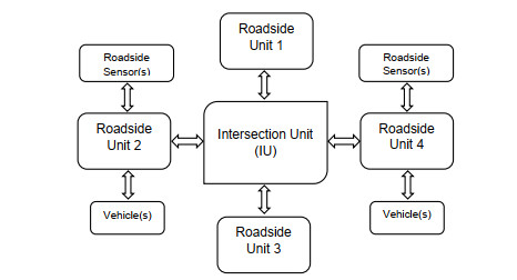
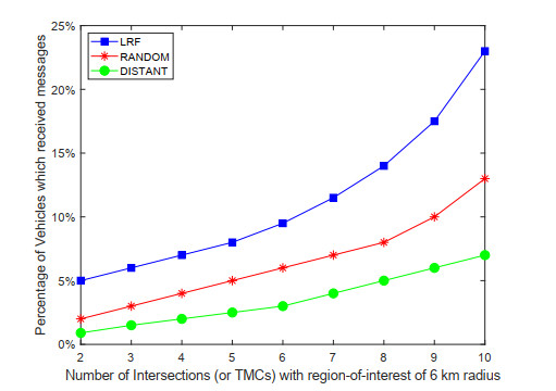
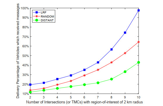
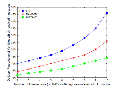
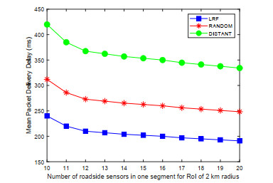
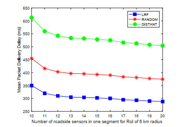
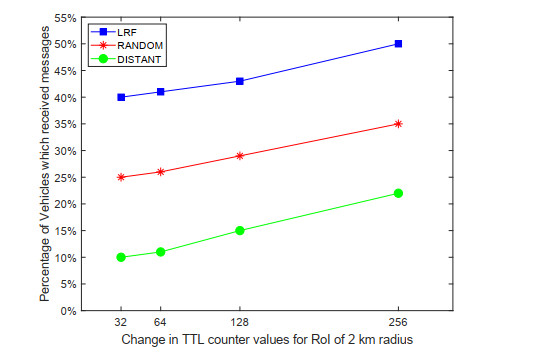
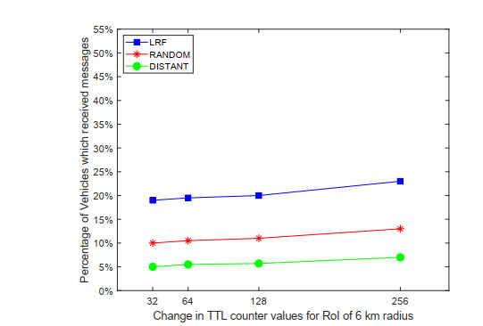
Reverse data delivery is one of the key operations in vehicular ad hoc networks which allows data delivery from roadside units (infrastructure) to vehicles. In the past, a number of data dissemination schemes have been proposed by researchers for the vehicular ad hoc networks to tackle the problem of data forwarding from vehicles and roadside units to data concentration points or Access Points (APs). In contrast, schemes for reverse data forwarding which allows a data concentration point to apprise the on-road vehicles about any eventuality or developing hazardous conditions are very few. This paper proposes a reverse data forwarding scheme which utilizes the characteristics of the road networks to inform passing vehicles of important information related to any accident, crash, or hazardous road conditions. The proposed scheme takes into account the geographical proximity factor by considering a localized sub-region/segment in the greater road network which is most adversely affected by the occurrence of some unfortunate road event. For its implementation, the scheme is dependent on DSRC-enabled roadside equipment to relay road-safety messages from AP to vehicles. In case if the passing vehicles are not fitted with DSRC on-board units, the scheme has the capability to directly interact with the variable-message signs on intersections with the objective of reaching as many vehicles as possible to increase the chances of message delivery. Simulation results using a small road segment confirm that the proposed scheme is more effective when the localized sub-region is smaller or in other words when more vehicles in the vicinity of the accident location are provided with pre-warning messages.
Citation: Farhan Khan, Sing Kiong Nguang. Location-based reverse data delivery between infrastructure and vehicles[J]. AIMS Electronics and Electrical Engineering, 2021, 5(2): 158-175. doi: 10.3934/electreng.2021009
Reverse data delivery is one of the key operations in vehicular ad hoc networks which allows data delivery from roadside units (infrastructure) to vehicles. In the past, a number of data dissemination schemes have been proposed by researchers for the vehicular ad hoc networks to tackle the problem of data forwarding from vehicles and roadside units to data concentration points or Access Points (APs). In contrast, schemes for reverse data forwarding which allows a data concentration point to apprise the on-road vehicles about any eventuality or developing hazardous conditions are very few. This paper proposes a reverse data forwarding scheme which utilizes the characteristics of the road networks to inform passing vehicles of important information related to any accident, crash, or hazardous road conditions. The proposed scheme takes into account the geographical proximity factor by considering a localized sub-region/segment in the greater road network which is most adversely affected by the occurrence of some unfortunate road event. For its implementation, the scheme is dependent on DSRC-enabled roadside equipment to relay road-safety messages from AP to vehicles. In case if the passing vehicles are not fitted with DSRC on-board units, the scheme has the capability to directly interact with the variable-message signs on intersections with the objective of reaching as many vehicles as possible to increase the chances of message delivery. Simulation results using a small road segment confirm that the proposed scheme is more effective when the localized sub-region is smaller or in other words when more vehicles in the vicinity of the accident location are provided with pre-warning messages.

| [1] | Road traffic safety (2017) In Wikipedia, The Free Encyclopedia. Available from: https://en.wikipedia.org/w/index.php?title=Road_traffic_safety&oldid=783832588 |
| [2] | Vehicle safety communications project final report HS-810-591. US Department of Transortation National Highway Traffic Safety Administration, Washington, DC, USA, 2006, pp. 1-10. |
| [3] | IEEE Standard 802.11p: IEEE standard for information technology telecommunications and information exchange between systems local and metropolitan area networks specific requirements; Part 11: Wireless LAN medium access control (MAC) and physical layer (PHY) specifications; Amendment 6: Wireless access in vehicular environments, 2010. |
| [4] | Cailean AM, Cagneau B, Chassagne L, et al. (2014) A survey on the usage of DSCR and VLC in communication-based vehicle safety applications. Proceedings of the 21st IEEE Symposium on Communications and Vehicular Technology in the Benelux (SCVT), 69-74 |
| [5] | Abuelsamid S (2016) New cars could be required to talk to each other as soon as 2020. Retrieved from https://www.forbes.com/sites/samabuelsamid/2016/12/13/nhtsa-finally-issues-draft-v2v-communications-rule-could-be-mandatory-from-2021 |
| [6] | Farquhar P (2016) There's one major obstacle to a driverless car future that tech can't solve -- and that's you. Retrieved from https://www.businessinsider.com.au/theres-one-major-obstacle-to-a-driverless-car-future-that-tech-cant-solve-and-thats-you-2016-12 |
| [7] | Nellore K, Hancke GP (2016) A survey on urban traffic management system using wireless sensor networks. Sensors 16: 1-25. |
| [8] | Zhao J, Cao G (2008) VADD: Vehicle-assisted data delivery in vehicular ad hoc networks. IEEE T Veh Technol 57: 1910-1922. |
| [9] | Skordylis A, Trigoni N (2008) Delay-bounded routing in vehicular ad-hoc networks'. Proceedings of the 9th ACM International Symposium on Mobile Ad Hoc Networking and Computing, 341-350. |
| [10] | Ding Y, Wang C, Xiao L (2007) A static-node assisted adaptive routing protocol in vehicular networks. Proceedings of the 4th ACM Workshop on Vehicular Ad Hoc Networks, 59-68. |
| [11] | Jeong J, Guo S, Gu Y, et al. (2009) TBD: Trajectory-based data forwarding for light-traffic vehicular networks. Proceedings of the 29th IEEE International Conference on Distributed Computing Systems, 231-238. |
| [12] | Jeong J, Guo S, Gu Y, et al. (2010) TSF: Trajectory-based statistical forwarding for infrastructure-to-vehicle data delivery in vehicular networks. Proceedins of the 30th IEEE International Conference on Distributed Computing Systems, 557-566. |
| [13] | Kenney JB (2011) Dedicated short-range communications (DSRC) standards in the united states. P IEEE 99: 1162-1182. |
| [14] | Camp T, Boleng J, Davies V (2002) A survey of mobility models for ad hoc network research. Wireless Communications and Mobile Computing 2: 483-502. |
| [15] | Carter A (2005) The status of vehicle-to-vehicle communication as a means of improving crash prevention performance. Tech. Rep. 05-0264. |
| [16] | Eze EC, Zhang S, Liu E (2014) Vehicular ad hoc networks (VANETs): Current state, challenges, potentials and way forward. Proceedings of the 20th International Conference on Automation and Computing, 176-181. |
| [17] | Máttyus G, Luo W, Urtasun R (2017) DeepRoadMapper: Extracting road topology from aerial images. Proceedings of the 2017 IEEE International Conference on Computer Vision, 3458-3466. |
| [18] | Wu H, Fujimoto R, Guensler R, et al. (2004) MDDV: A mobility-centric data dissemination algorithm for vehicular networks. Proceedings of the 1st ACM International Workshop on Vehicle Ad Hoc Network, 47-56. |
| [19] | Khan F, Nguang SK (2020) Location-based data delivery between vehicles and infrastructure. IET Intell Transp Sy 14: 288-296. |
| [20] | Khan F, Nguang SK (2017) LRF: Location-based reverse forwarding for infrastructure-to-vehicle data delivery. Proceedings of the 9th International Conference on Signal Processing Systems, 32-36. |
| [21] | Li Y, Shi X, Lindgren A, et al. (2018) Context-aware data dissemination for ICN-based vehicular ad hoc networks. Information 9: 263. |
| [22] | Zhang L, Afanasyev A, Burke J, et al. (2014) Named Data Networking. ACM SIGCOMM Comput Commun Rev 44: 66-73. |
| [23] | Xu Y, Tong S, Zhang T, et al. (2020) Compass: Directing named data transmission in VANETs by dynamic directional interfaces. IEEE Access 8: 8418-8435. |
| [24] | Ahed K, Benamar M, Lahcen AA, et al. (2020) Forwarding strategies in vehicular named data networks: A survey. Journal of King Saud University - Computer and Information Sciences. |
| [25] | Boukerche A, Coutinho R (2019) LoIcen: A novel location-based and information-centric architecture for content distribution in vehicular networks. Ad Hoc Networks 93: 101899. |
| [26] | Boukerche A, Coutinho R, Yu X (2017) LISIC: A link stability based protocol for vehicular information-centric networks. IEEE 14th International Conference on Mobile Ad Hoc and Sensor Systems (MASS), 233-240. |
| [27] | Coutinho R, Boukerche A, Yu X (2018) A novel location-based content distribution protocol for vehicular named-data networks. IEEE Symposium on Computers and Communications (ISCC), 01007-01012. |
| [28] | Sousa M, Arajo FR, Sampaio L (2018) A link-stability based interest-forwarding strategy for vehicular named data networks. IEEE Internet Comput 22: 16-26. |
Figures(11) / Tables(2)

Farhan Khan, Sing Kiong Nguang. Location-based reverse data delivery between infrastructure and vehicles[J]. AIMS Electronics and Electrical Engineering, 2021, 5(2): 158-175. doi: 10.3934/electreng.2021009


 DownLoad: