Research article Special Issues

Italian landscape macrosystem (ILM) from urban pressure to a National Wildway

  • Thirty years after the widespread establishment of the concepts of environmental continuity in Europe and Italy, linked to the EU Habitat Directive and the Natura 2000 project, these have almost completely lost their impetus. After having fostered a very intense scientific and political/administrative/managerial period, these concepts have produced only a few virtuous examples of implementation. The study presented in this paper shows that today national environmental quality is almost entirely based on land use categories that are scarcely protected and not subject to sufficiently binding planning. Moreover, their functional structure and extension/quality depend on how the local and global market impact spatially complementary categories mostly affected by anthropic action, which instead undergo efficiently planned changes. From the fundamental paradigm of "ecological networks" the interests of the scientific world and local authorities have shifted to other fronts, losing that physical and conceptual cohesion inherent in "environmental continuity" as a value in itself. The availability of recent, very advanced data helps take stock of this issue and verify critical points on the national territory that have been unresolved for several decades, but still rife with potential for the application of models of international value.

    Citation: Bernardino Romano, Andrea Agapito Ludovici, Francesco Zullo, Alessandro Marucci, Lorena Fiorini. Italian landscape macrosystem (ILM) from urban pressure to a National Wildway[J]. AIMS Environmental Science, 2020, 7(6): 505-525. doi: 10.3934/environsci.2020032

    Related Papers:

    [1] Beth Ravit, Frank Gallagher, James Doolittle, Richard Shaw, Edwin Muñiz, Richard Alomar, Wolfram Hoefer, Joe Berg, Terry Doss . Urban wetlands: restoration or designed rehabilitation?. AIMS Environmental Science, 2017, 4(3): 458-483. doi: 10.3934/environsci.2017.3.458
    [2] Jennifer K. Costanza, Robert C. Abt, Alexa J. McKerrow, Jaime A. Collazo . Linking state-and-transition simulation and timber supply models for forest biomass production scenarios. AIMS Environmental Science, 2015, 2(2): 180-202. doi: 10.3934/environsci.2015.2.180
    [3] Rachel R. Sleeter, William Acevedo, Christopher E. Soulard, Benjamin M. Sleeter . Methods used to parameterize the spatially-explicit components of a state-and-transition simulation model. AIMS Environmental Science, 2015, 2(3): 668-693. doi: 10.3934/environsci.2015.3.668
    [4] Dominic Bowd, Campbell McKay, Wendy S. Shaw . Urban greening: environmentalism or marketable aesthetics. AIMS Environmental Science, 2015, 2(4): 935-949. doi: 10.3934/environsci.2015.4.935
    [5] Ian C. Mell . Establishing the rationale for green infrastructure investment in Indian cities: is the mainstreaming of urban greening an expanding or diminishing reality?. AIMS Environmental Science, 2015, 2(2): 134-153. doi: 10.3934/environsci.2015.2.134
    [6] Frank Chambers, Alistair Crowle, John Daniell, Dmitri Mauquoy, Julia McCarroll, Nicole Sanderson, Tim Thom, Phil Toms, Julia Webb . Ascertaining the nature and timing of mire degradation: using palaeoecology to assist future conservation management in Northern England. AIMS Environmental Science, 2017, 4(1): 54-82. doi: 10.3934/environsci.2017.1.54
    [7] Filippo Sgroi . Agriculture and tourism: economic evaluation of sustainable land management. AIMS Environmental Science, 2022, 9(1): 83-94. doi: 10.3934/environsci.2022006
    [8] Amanda Swearingen, Jessica Price, Janet Silbernagel, Randy Swaty, Nicholas Miller . State-and-transition simulation modeling to compare outcomes of alternative management scenarios under two natural disturbance regimes in a forested landscape in northeastern Wisconsin, USA. AIMS Environmental Science, 2015, 2(3): 737-763. doi: 10.3934/environsci.2015.3.737
    [9] Lawrence H. Tanner, Megan M. Vandewarker . Significance of vegetation cover differences on albedo and soil carbon on a basaltic sandplain in southern Iceland. AIMS Environmental Science, 2019, 6(6): 435-444. doi: 10.3934/environsci.2019.6.435
    [10] Catherine S. Jarnevich, Tracy R. Holcombe, Catherine Cullinane Thomas, Leonardo Frid, Aaryn Olsson . Simulating long-term effectiveness and efficiency of management scenarios for an invasive grass. AIMS Environmental Science, 2015, 2(2): 427-447. doi: 10.3934/environsci.2015.2.427
  • Thirty years after the widespread establishment of the concepts of environmental continuity in Europe and Italy, linked to the EU Habitat Directive and the Natura 2000 project, these have almost completely lost their impetus. After having fostered a very intense scientific and political/administrative/managerial period, these concepts have produced only a few virtuous examples of implementation. The study presented in this paper shows that today national environmental quality is almost entirely based on land use categories that are scarcely protected and not subject to sufficiently binding planning. Moreover, their functional structure and extension/quality depend on how the local and global market impact spatially complementary categories mostly affected by anthropic action, which instead undergo efficiently planned changes. From the fundamental paradigm of "ecological networks" the interests of the scientific world and local authorities have shifted to other fronts, losing that physical and conceptual cohesion inherent in "environmental continuity" as a value in itself. The availability of recent, very advanced data helps take stock of this issue and verify critical points on the national territory that have been unresolved for several decades, but still rife with potential for the application of models of international value.


    This paper is part of a line of research on territorial continuity of ecosystems (biopermeability and ecological networks) that has been very active in Europe and Italy between 1995 and 2005, leading to some important results, including applications. However, before 2010, it ebbed leaving few traces still visible today. This topic has involved several scientific sectors, such as landscape ecology, forest sciences, zoology, biological sciences, plant ecology and territorial sciences, often also in an interdisciplinary perspective. Vast national and international scientific literature has been produced, to which reference should be made for a more in-depth examination of concepts and definitions [1,2,3,4,5,6,7,8,9,10,11,12] and specific departments within

    government agencies and universities have been set up too. The debate in Italy has been very intense and marked by innumerable conferences, participation in European projects, funding of university research, with five regions out of 20 (Umbria, Lombardy, Emilia Romagna, Tuscany and Marche) that have also enacted targeted regulations [13,14,15,16,17]. The “ecoregional” approach should also be underlined, which, starting from an identification of the world's ecoregions [18], was also declined in Italy by WWF with the identification of 24 priority areas for biodiversity for the Alpine ecoregion and 36 for that of the Central Mediterranean. Although progress in research has been significant, interest has waned rather suddenly and prevented the topic from being included in a broader national strategy, in order to produce more consistent results than those achieved by a few regions. However, research on ecological networks has produced a spectrum of knowledge fuelling other areas of interest, such as greenways and ecosystem services, which even today are the scientific core business of various important Italian research centers [19,20,21,22,23].

    The goal of this research is to review, twenty years later, the critical issues of spatial continuity in Italian territorial systems having greater biopermeability, i.e., in minimum conditions of residual naturalness or man-made changes, so as to allow at least the transit of large animal species without continuous and intense disturbance [24]. Using the data produced over the last twenty years, we intend to verify the quality of some territorial layers with respect to their potential functions of support and dissemination of high-end ecosystem qualities.

    There are areas that change shape and layout as a result of market trends (e.g., agricultural areas) or abandonment (e.g., forest or semi-natural areas), outside of any established supervision and whose results can only be assessed after at least a decade. An interesting aspect is that these various systems undergo mutual interchange effects caused by different drivers, whose dynamics stop and become irreversible for those parts that become urbanized. As a result, their development ends in the only state that does not allow retrofitting and that destroys soil resources [25,26].

    This study identifies two macro-types of landscape-environmental mosaics: the first includes areas with prevailing anthropogenic physiognomy that tend to be more "managed", while the second encompasses areas of higher environmental quality or in transition and much less regulated by forms of planning. These two macrosystems exchange surfaces over time, but the dynamics of transformation and mutual substitution are only sometimes regulated by planning, while in many cases they are spontaneous and influenced by the market, economic crises and local or global events lacking any specific control. Some systems, such as urbanized areas, are generally managed through local urban planning, despite weaknesses or the spread of illegal phenomena [27,28]. For other systems, there are no forms of highly binding planning, excluding any parts falling within specially regulated areas (parks or nature reserves, hydrogeological risk districts and international environmental constraints such as UNESCO or Natura 2000 sites).

    To achieve the result, we used the European Corine Land Cover classification [29,30]: from 43 of the 44 land cover categories (maritime environments were excluded) six Italian Landscape Mosaics (ILMs) were extracted and then grouped into three landscape macrosystems (Table 1). The six ILMs consist of artificialized areas covered by urbanization (U), intensive agriculture (IA), extensive agriculture (EA), forests (F), natural and semi-natural areas (SN) and water bodies (W). This category has undergone the least changes in its expanse, at least since World War Ⅱ. Indeed, the last reclamations that have taken important areas of water away from the territory date back to the 1960s although, until recently, waterways have been subject to significant regulation and damming that, in several cases, have altered the geography of their courses and sections. In the various historical periods, the six ILMs have frequently interchanged owing to economic, technical and social reasons, making the country assume different prevailing physiognomies over time and with varying and uneven levels of reversibility and resilience.

    Table 1.  Clusters of ILM systems and ILM^ and ILM* macrosystems from CLC categories.
    ILM macrosystem ILM System CLC code CLC categories
    ILM^ U 111 Continuous urban fabric
    112 Discontinuous urban fabric
    121 Industrial or commercial units
    122 Road and rail networks and associated land
    123 Port areas
    124 Airports
    131 Mineral extraction sites
    132 Dump sites
    133 Construction sites
    141 Green urban areas
    142 Sport and leisure facilities
    IA 211 Non-irrigated arable land
    212 Permanently irrigated land
    213 Rice fields
    221 Vineyards
    222 Fruit trees and berry plantations
    EA 223 Olive groves
    231 Pastures
    241 Annual crops associated with permanent crops
    242 Complex cultivation patterns
    243 Land principally occupied by agriculture, with significant areas of natural vegetation
    244 Agro-forestry areas
    ILM* F 311 Broad-leaved forest
    312 Coniferous forest
    313 Mixed forest
    SN 321 Natural grasslands
    322 Moors and heathland
    323 Sclerophyllous vegetation
    324 Transitional woodland-shrub
    331 Beaches, dunes, sands
    332 Bare rocks
    333 Sparsely vegetated areas
    334 Burnt areas
    335 Glaciers and perpetual snow
    W 411 Inland marshes
    412 Peat bogs
    421 Salt marshes
    422 Salines
    423 Intertidal flats
    511 Water courses
    512 Water bodies
    521 Coastal lagoons
    522 Estuaries

     | Show Table
    DownLoad: CSV

    The six ILMs have extremely diverse levels of perceptive and eco-functional quality and the transformations that occur over time exchanging their structures produce, in parallel, landscape and ecotonal changes with effects that can be estimated over fairly long periods of time. In particular, this relates to the consequences on the expanse and types of habitats, as well as on the layout and functionality of local and sub-national ecological networks. As mentioned earlier, both topics have been studied in-depth in Italy since the mid-1990s [31,32,33,34].

    As mentioned earlier, we obtained the landscape mosaics (ILM) using the CORINE Land Cover (CLC) categories that have been a standard for the whole of Europe for thirty years now. At the third level of detail, there are 44 types of land cover from satellite surveys, produced since 1990 and subsequently updated to 1996, 2000, 2006, 2012 and 2018. The data used in this paper is the one updated to 2018 and downloaded from the following website: http://groupware.sinanet.isprambiente.it/uso-copertura-e-consumo-di-suolo/library/copertura-del-suolo/corine-land-cover/clc2018_shapefile (access April 2020). The data survey techniques include a minimum mapping unit (MMU) of 25 hectares with a minimum linear element size of 100 meters, while the MMU to record changes over time (LCC) is 5 hectares (http://www.isprambiente.gov.it/it/temi/suolo-e-territorio/copertura-del-suolo/corine-land-cover).

    The definition of the ILMs for clusters of CLC categories is shown in Table 1 and in most cases allocation is fairly automatic, while some specifications should be made for the inclusion of CLC categories 221,222,223 in the "EA" ILM. These types of land use have different connotations in the country: in some cases, they connote IA, while in others EA. Considering that IA is mainly recognizable in northern Italy, while EA forms predominate in the larger peninsular section, the latter has been used to characterize them all.

    The ILM mosaics were then divided into two macrosystems: ILM^ = (U+IA+EA) and ILM* = (F+SN+W) with ILM^ including the mosaics with the greatest land artificialization (57%), and ILM* with the greatest natural parts (42%) (Table 2).

    Table 2.  Values of the HII and GPII indicators for ILM systems and macrosystems.
    ILM N2k sites N2k U PA
    Macrosystem System Area(ha) National rate Area (ha) HII Area (ha) GPII
    ILM^ U 1679832 0.06 19682 0.01 46678 0.03
    IA 8313463 0.28 0.57 242812 0.03 0.032 428068 0.05 0.058
    EA 7319508 0.24 284709 0.04 529386 0.07
    ILM* F 7914441 0.26 1403234 0.18 2226128 0.28
    SN 4516595 0.15 0.43 969416 0.21 0.198 1646910 0.36 0.318
    W 389961 0.01 165810 0.43 198822 0.51
    Total 30133800 1.00 3085663 0.10 5075991 0.17

     | Show Table
    DownLoad: CSV

    In the case of Italy, even other sources of land use maps or regional technical maps (LUM) have been available for several years, with much higher levels of detail than CLC (1:10,000, 1:5,000), but they present various kinds of problems that have prevented us from using them for this study. The most significant issue concerns update dates, as they go from 2000 to the present day with uncoordinated chronological scans managed exclusively on the basis of the programs of individual Regions. Besides the difference in update dates, there are no fixed standards for synoptic categories: even if most regions tend to follow the CLC synoptic scheme, this is not generalized and can generate considerable ambiguities. Finally, there is no standardization of the survey method for elementary polygons, especially for urbanized areas, which are sometimes extracted as built-up areas and in other cases as artificialized areas. Therefore, having to produce a homogeneous survey of the whole of Italy, we decided to use CLC coverage even if the resolution is on average lower than that of LUMs.

    Other layers that have been used concern Natura 2000 (N2k) sites and protected areas (PA). Natura 2000 habitats on land (SCIs and SCZs) were taken from the site of the Ministry of the Environment (https://www.minambiente.it/pagina/sic-zsc-e-zps-italia-access April 2020), with a declared area of 3,085,663 ha. Protected areas on land refer to the Ⅵ Official List of Protected Natural Areas (EUAP) (https://geodati.gov.it/resource/id/m_amte:299FN3:06c67978-18c8-4da7-ff26-443d4f700c2d - access April 2020), established under Law no. 394/91, Framework Law on protected areas. The official list currently in force is the one included in the 6th Update approved by Ministerial Decree 27/04/2010 and published in the Ordinary Supplement no. 115 to the Official Gazette no. 125 of 31/05/2010, with a declared area of 3,163,591 ha. The methodology used is summarized in the flow chart of Figure 1.

    Figure 1.  Methodological flow chart.

    The clustering of the 43 CLC categories in the six ILM mosaics, carried out as shown in Table 1, has led to the conclusion that three of them, intensive agriculture (IA), extensive agriculture (EA) and forest areas (F), are equally distributed at national level, with an incidence of about 25% each, covering ¾ of the country (Table 2, Figure 2). Semi-natural areas (SN) account for 15%, while water bodies (W) and urbanization (U) occupy the remaining space, 6% and 1% respectively. Table 2 also shows the two ILM^ and ILM* macromosaics covering 57% and 42% of the country respectively.

    Figure 2.  Values of the HII and GPII indicators for ILMs on a national scale.

    Within ILM* the most significant extension concerns forests (26%), while semi-natural areas (15%) have been greatly eroded and, as mentioned earlier, water covers a very small area. A number of considerations can be made from Figure 1 showing the nationwide distribution of the six ILMs. Urbanized areas (U) have been studied extensively in recent years. At present, they are probably the most thoroughly studied item in terms of geographical distribution and determinants of their development and therefore we refer to the considerable scientific literature on the subject [35,36,37,38,39,40].

    These areas include built-up/artificialized/sealed surfaces derived from the transformation of other land covers. Among all the mosaics identified, they are the ones with the highest level of irreversibility, at least in the mid-term. The development of this coverage throughout the country has been on the rise for seventy years [41,42,43]. Even the current the trend is of ongoing growth, albeit at different paces in the various historical periods. Spatial configuration is partly regulated by urban planning tools. However, especially over the last thirty years, this is left mostly to the implementation of local public-private negotiation procedures lacking any local strategic control.

    As shown in Table 1 and Figure 3, intensive agriculture (IA) takes on at least 5 different physiognomies and is concentrated spatially in a few areas of the country: the Po Valley-Veneto area, the hilly coastal strip between Emilia Romagna and Marche and the enormous interregional area between Molise, Puglia, Campania and Basilicata, having an expanse equal to one third of the Po Valley-Veneto area. Other evident areas of concentration are found in the two major islands, Sicily and Sardinia, but involve larger expanses and greater spatial fragmentation. The entire Apennine belt, from Liguria to Calabria, as well as the entire eastern half of Sardinia, appear to be substantially lacking in IA areas, which are governed by local and global market trends in terms of typology and size. Extensive agriculture (EA), represented by the six CLC categories in Table 1, is marked by a radically different physiognomy. It is widely distributed at almost constant density on the pre-Alpine strip and across the country, in addition to the main islands, showing a more evident concentration only in central-southern Puglia. Excluding some territorial strips where they are totally lacking, forest areas too are distributed rather uniformly in the country, but with considerable variations in quality and structure that the CLC data do not capture. One of these (Figure 3) is the Po Valley-Veneto area, in continuity with the entire hilly Adriatic coastal strip, if we exclude a very small forest area in the Gargano promontory. A similar characteristic can be found in Sicily, where almost the entire territory has been deforested except for a small northeastern area. Forest areas can be considered governed by dedicated programs, although very partially and only in the past. At present they are essentially growing due to natural spatial recovery caused by the abandonment of EA and mainly SN, but in the past they were subject to numerous artificial reforestation initiatives. Forestry statistics from 1947 report 5.6 million hectares of forest, while currently the CLC 2018 mapping reports 8 million hectares (http://www.georgofili.info/contenuti/il-rimboschimento-naturale-in-italia/1128- access April 2020). Historically, reforestation has been the main tool of Italian forestry and mountain policy and was promoted initially for soil protection and, since the second half of the 1970s, for wood production. Reforestation with conifers carried out in Italy from 1877 to 1983 covers an area of about 1.2 million hectares, including areas subject to forest fires [44,45,46,47,48].

    Figure 3.  National geographical distribution of the six identified ILM systems.

    Semi-natural areas (SN), derived from the pooling of nine CLC types (Table 1), have shrunk considerably overall, accounting for about one sixth of the country. Their highest appreciable density is found along the entire Alpine arch, Sardinia and the central Apennines, with smaller densifications in other smaller geographical areas. These territorial units include areas of extremely varying environmental quality and are subject, in part, to fluctuations over time due to the abandonment or resumption of other uses, such as farming.

    Water bodies (W) have been retaining their expanse for many years, even though they are subject to considerable regulation and hydraulic control, since the last national reclamations that had impact on their spatial dimensions date back to the early 1960s. As is well known, Italy is rather lacking in water bodies (W). Apart from some large lakes, lagoon areas and rivers in the north, in central Italy there are only some lakes of volcanic/tectonic/artificial origin, in addition to the large Arno and Tiber rivers; while the whole of southern Italy and the islands lack large water bodies, although they have a rather dense hydrographic network and many artificial lakes.

    Regardless of their location and concentration, ILMs differ greatly in terms of environmental quality. An indication of this has been obtained by assessing the impact on each of them of N2k habitats and the agammaegation of N2k and PA habitats, using the following indicators: Habitat Incidence Index (HII) and Global Protection Incidence Index (GPII).

    HII=ni=1¯SN2kinj=1SILMj (1)
    GPII=ni=1ˆS(N2kPA)inj=1SILMj (2)

    Where:

    ¯SN2ki= Surface of the i-teenth sections of Natura 2000 sites falling within j-teenth areas of ILM macromosaics

    ˆS(N2kPA)i= Surface of the i-teenth sections of agammaegation of N2000 and PA sites falling within j-teenth areas of ILM macromosaics

    SILMj= Surface of the j-teenth areas of ILM mosaics

    The decision to use the habitats surveyed by the European program Natura 2000 (SCIs and ZSCs), and then the agammaegation of these habitats and protected areas, is linked to the different meanings of these two entities. The presence of habitats only indicates the eco-biological qualities of an environmental system, since European SCIs/ZCSs have been identified and their boundaries marked on the basis of specialized naturalistic knowledge. Obviously, N2k censuses carried out in the various European countries are not exhaustive of the conservation status of habitats, but the underlying logic is the one described.

    Over the years, the identification and establishment of protected areas has been based and continues to be based on partially different methods. It is always true that special environmental protection is given to areas having high eco-biological values (and in fact the two systems, N2k and PA, overlap in Italy by 40%). However, perimeters also follow other historical-cultural and architectural-testimonial criteria and are often affected by complex political negotiation processes between the competent national, regional and local authorities. This aspect is also evident from the data in Table 2 and above all from Figure 2, which shows that in all ILMs PAs cover larger areas than N2k.

    Table 2 also clearly shows that, the ILM* macrosystem, accounting for just over 40% of the country overall, is encompassed in N2k habitats for a fifth of its extension and in the N2kPA complex for about 32%. Conversely ILM^, which occupies most of the national territory (almost 60%), is marked by almost total environmental impoverishment with HII and GPII indicators that do not exceed 0.03 and 0.06 respectively. Excluding W which, given its very small extension has both indices ranging between 0.40 – 0.50, among the six ILM categories, SN - with over 20% of its extension covered by N2k and 36% by N2kPA - is the most important system from the environmental point of view, more than forests that do not go beyond HII = 0.18 and GPII = 0.28. As shown in Table 1, SN is highly varied typologically and includes transitional woodland-shrub and burnt areas too. Therefore, it probably represents the most vulnerable areas of the country marked by considerable ambiguity of use, deriving both from the abandonment of agricultural or other activities and from primary eco-biological conditions (high altitude pastures, rocky complexes and harsh and inaccessible morphologies). If one part defends itself through morphology, another part of SN instead risks yielding to transformative activities that fail to acknowledge its environmental worth, often due to objective difficulties in perceiving it.

    In addition to analyzing how ILM systems are structured nationwide (Figure 3), we also performed a survey of the regions spotlighting differences among them. Figure 4 shows the outlines of the ILMs in the regions and their relationship with the national standard, together with the HII value, since we chose to highlight only the incidence of N2k habitats, deemed more significant for the reasons mentioned earlier. The national outline is particularly recognizable in Piedmont, Lazio and Abruzzo and, a little less so, in Campania, while in the remaining regions one or two prevailing systems are always found. In Valle d'Aosta, Trentino A.A, Liguria and Tuscany these are semi-natural (SN) or forest (F) systems, while in Lombardy, Emilia Romagna, Veneto, Marche, Molise and Basilicata it is the intensive agriculture system (IA). Most of the regions are below the national average urbanization threshold, except Piedmont, Friuli, Emilia, Lazio, Puglia and Campania, which are in line with the national average. Only Lombardy and Veneto exceed national average urbanization. Notwithstanding some prevailing systems, there are cases in which the ILMs are considerably below the national average threshold: this is the case, for example, of AI that has extremely lower levels in Valle d'Aosta, Trentino A.A., Liguria and, in part, Calabria. In the case of forests (F), they are particularly lacking in Puglia and Sicily, while EA is significant in Lombardy, Friuli, Trentino A.A. and again Liguria. SNs are very scanty in Emilia Romagna, Puglia and Umbria, while only Trentino A.A., Valle D'Aosta and Umbria exceed the national average.

    Figure 4.  Regional distribution of ILMs and HII values in every subsystem.

    Regarding the HII indicator, in almost all regions its significant values are all found in the ILM* macrosystem. The highest values of this indicator concern the water system that, in several cases, exceeds 50% (Veneto, Liguria, Umbria, Lazio, Abruzzo, Puglia, Campania and Sardinia) with Liguria, Umbria and Puglia nearing 100%. The prevalence of SN in central-northern regions is confirmed, if compared to F, while these two values range between 25% and 50% in some southern regions (Abruzzo, Puglia, Campania, Sicily and Sardinia).

    It is interesting to note the scarce relevance of the HII indicator in all ILM categories in Valle d'Aosta, Piedmont, Emilia, Molise, Basilicata and Calabria, which is something worth investigating further.

    As already shown in the national case, the irrelevant contribution of the ILM^ macrosystem to the habitat incidence (HII) indicator is also confirmed at the regional scale, excluding some limited differences in Liguria and a few southern regions (Puglia, Campania, Sicily and Sardinia).

    Aside from water, SN can therefore be considered the ILM system mostly marked by environmental quality but, at the same time, the one in the most precarious state. Most territories showing high environmental quality belong to the ILM* macrosystem, which is also the one with the highest instability over time, as it is less significant and relevant than ILM^ from an economic standpoint and highly dependent on it in terms of extension and quality.

    Evidence of this instability can be found by examining the changes undergone by ILM types over the years through interexchange processes. The data distributed by ISPRA on CLC time periods (http://www.sinanet.isprambiente.it/it/sia-ispra/download-mais/corine-land-cover) show that from 2000 to 2006, the areas that have changed state account for 6‰ of the national territory (approximately 180,000 ha) with a very small average size of patches, about 18 ha. The maximum expanses that have changed in these six years exceeding 500 ha are found mainly in Sardinia, with migrations within the 321-323 category (SN), while Lombardy recorded the most significant transformation into urban areas with 400 ha transitioning from 211 (IA) to 112 (U). As mentioned previously, changes that involve transitioning to the urban category have the greatest impact because they are not reversible, at least in the mid-term, unlike others.

    In the following 12 years, between 2006 and 2018, this change affected 1.6% of the country, i.e., more than 500,000 ha (Table 3), with reductions concerning mainly IA and SN systems to the benefit of forest (F) and urbanized (U) areas. Confirming the established precariousness of SN in the 12 years considered, more than 72,000 ha of IA were lost, and as much as 178,000 ha of SN that become in total 156,000 ha of urban areas, 9500 ha of extensive agriculture and 86,000 hectares of forests. Of the 250,000 ha lost, 62% became urban and 30% forests. The additional urban areas and the SN lost correspond to a square of 40 km per side (circle with 22 km radius), i.e., almost 5 times the city of Rome within the ring road in just over a decade.

    Table 3.  Changes in the ILMs in the 2006-2018 timeframe (Data from: http://www.sinanet.isprambiente.it/it/sia-ispra/download-mais/corine-land-cover-access April 2020.
    ILM 2006 (ha) 2006% 2018 (ha) 2018% 2006–2018 (ha) square (km)
    ILM^ U 1487438 0.049 1643130 0.055 155692 39.5
    IA 8401100 0.279 8329008 0.277 -72092 26.8
    EA 7326042 0.243 7335614 0.244 9572 9.8
    ILM* F 7843161 0.260 7929075 0.264 85914 29.3
    SN 4686098 0.156 4507013 0.148 -179085 42.3
    W 389961 0.013 389961 0.013 0 0.0
    30133800 1.000 30133800 1.000 0.00

     | Show Table
    DownLoad: CSV

    The foregoing combination of land use conversion has been ongoing in its dynamics for many decades now, involving first and foremost semi-natural (SN), and then forest (F) and urban (U) ILM systems. SN and F variations produce the most significant environmental consequences. Only 20% of SN is protected from profound alterations and changes by N2k and PA tools. So, 80% of this ILM category tends to be exposed to generalized damage without significant obstacles. This damage is caused by changes to the complementary ILM^ elements mostly influenced by the market and by local and global economies. This implies that, while theoretically assuming that protected SN sections remain unaltered over time, the actions on the rest cause significant erosion in potential ecological connections that SN and F assure among their more "noble" parts, that is to say that 20% protected for various reasons [49,50]. The case of forests (F) is different, since in general, they have increased their extension owing to agricultural abandonment, [51]. This dynamic should be considered positively given the effects on CO2 absorption, climate mitigation and the increased performance of ecosystem services associated with forest cover [52]. However, part of the scientific world is against forest expansion, considering it the cause of ecological simplification of the territory and of a decrease in ecotonal sectors that are particularly important for biodiversity [53,54]. As our analysis has shown, the ILM* macrosystem includes the highest concentration of the most important areas in terms of ecological and environmental quality and connections between ecosystems. By transferring these concentrations to 9 km2 quadrants (3x3 km grid) through discretization, we can highlight the strategic structure of the national ecosystem (Figure 4) using a spatial density index of ILM* elements (dILM*) geostatistically calculated by means of kernel density.

    dILM=SILMSgrid (3)

    Where

    SILM* = surface of the systems belonging to the ILM* macrosystem contained within the 3x3km plot;

    Sgrid = surface of the 3x3 km plot forming the grid (9 km2)

    The quadrants having a dILM* > 0.75 cover an area of almost 13 million hectares, i.e., about 40% of the country (Table 2), but only one fifth of this area is censused as belonging to a habitat of EU importance (HII = 0.20). However, as mentioned earlier, the importance of unprotected ILM*sections is tied to their function of connecting core environmental areas found both within N2k habitats and, more generally, in protected areas and in all those other fragments of ecosystems and microecosystems that have not been officially censused, despite being sites of significant biodiversity. Kernel geostatistical estimation clearly shows (Figure 4) peak concentrations of dILMs* at national level mostly along the Alpine arc and the Apennines, with additional concentrations in the larger islands. While the spatial continuity of this considerable concentration is very significant in the Alpine area, it diminishes along the peninsular axis. There is a gradual drop in density with a latitudinal gradient from North to South, in addition to some evident interruptions in continuity (dILM* 0), the most significant being those localized in points 1, 2 and 3 in Figure 5.

    Figure 5.  Geostatistical representation of the national configuration of the dILM* index represented by spatial concentration on a 9 km2 grid. The three spots (1, 2 and 3) of interruption in latitudinal territorial continuity of dILM* are highlighted.

    By setting a latitudinal profile of the dILM* parameter (Figure 6) along the 1,200 km of the peninsula, the two aspects described are emphasized and the points that lose magnitude are clearly the three located in Umbria, Campania and Calabria. The studies mentioned in our introduction, conducted in the mid-1990s but based on data from the mid-1970s (Geotecneco, Ministry of Public Works), showed the same weaknesses that half a century later are largely confirmed on the basis of last generation digital data. Figure 5 shows, along the dILM* distribution curve, the sequence and frequency of N2kUPA agammaegate spaces that in our study were taken as a measure of ecological and environmental quality in the country. The minimum points 1, 2 and 3 are always located where there are protection vacuums, but relatively close to N2kPA systems.

    Figure 6.  Figure 5 outlines the profile of the dILM* index (y axis) along the Apennines (km x axis) and relationship with the distribution of the N2kPA system and the succession of regions. In the three maps below (source: De Agostini Map) the geographical characteristics of the three sections of the national minimum dILM* are detailed.

    The detailed territorial analysis of the three weaknesses shows that they are the following geographical sectors, all marked by an important concentration of infrastructural, settlement and farming elements, i.e. those that largely characterize the ILM system^: Strada Centrale Umbra-Flaminia (Umbria); Valle del Fiume-Via Appia (Campania), Valle del Fiume-Crati (Calabria).

    Figure 6 shows a more detailed dILM* profile analysis and the areas falling within N2k and PA sites, highlighting their considerable territorial spread. The dILM* decline already obtained from the national profile in Figure 5 is shown in Figure 6 with a greater spatial definition highlighting that discontinuities are locally far more complex and broken down in different negative peaks (Figure 7).

    Figure 7.  Tracking of the detailed profiles of the dILM* index (y axis) of the three national minimum dILM* sections (see Figure 5).

    This study conducted at national and regional level has highlighted the importance of ILM* systems as the key players in the environmental protection of the country with reference to historically established tools for this purpose (protected and special regime areas identified in the N2KPA core areas) and the ecological-environmental continuity needed to ensure the best functionality of these core areas. Although with different and more ineffective methods, knowledge and conceptual expressions, this condition has been outlined since the mid-1990s. However, until the present day no impactful government actions have been planned to recognize the quality and strategic function of the ILM* system in the setting up of ecological networks. Ultimately, apart from water bodies, the SN can therefore be considered the ILM system having high average environmental quality but, at the same time, the most unstable and least managed through dedicated and binding planning tools.

    Even some legislative attempts aimed at limiting, albeit indirectly, the effects of degradation and destruction of these territorial elements, such as the laws limiting land take, have been unsuccessful either at national or regional level, mainly due to pressure from lobbies against the limitation of building activities. Therefore, as stressed earlier, the extent, quality and geographical location of ILMs* are greatly influenced by movements affecting the complementary macrosystem, i.e., the ILM^. Changes in the latter are made according to market convenience and using weak forms of planning. It has been proven that, at different territorial scales, the ILM^ macrosystem is rather lacking in environmental value although, in some limited cases, some value worth protecting has been recognized, such as UNESCO sites [55,56].

    In the proposals put forward in the past, and largely ignored by politicians, the establishment of a National Ecological Network was viewed as the most effective tool to draw attention to the management of the ILM* macrosystem, as several European countries have done for several decades [57,58,59,60,61,62]. Some attempts to draft a national project were made in the embryo in the 1990s within the framework of the "Appenino Parco d'Europa - APE" (Apennines European Park) project [63,64], but then were not implemented.

    The ecological connection between natural territories, in particular subject to special forms of protection such as protected areas, constitute a very vast field of research that involves multiple scientific issues. Naturally, among the most active are those of conservation biology and ecology which have produced continuous results over time at different territorial scales, from the continental one [65,66,67] to the local one [68,69]. A central problem that has arisen since the beginning of the debate on the topic concerned the possibility of applying the concepts of connectivity in territorial control tools: the knowledge, although advanced, acquired in the field of biological, ecological and natural sciences has on average had a high quality, but did not manage to land effectively in projects and plans for territorial and urban transformation as they were neglected by planners and administrators. After all, the development of territorial techniques managed by architects and engineers had much more chance of passing through the rules and plan drawings, but were in general much more schematic and scientifically weak. The first appreciable results therefore emerged when the interdisciplinary dialogue between ecological sciences, planning and operational management of the territory has densified and spread in the country, but it is a process not yet settled that will require a few more years of training and above all a national regulatory framework that unifies the various regional legislative initiatives.

    The calculations produced in our study show that, especially along the latitudinal line of the Apennines, there are important interruptions in continuity that tend to worsen in present conditions: in recent years settlement pressure on land take, that started in the post-World War Ⅱ period, has eased, but not pressure on infrastructure, which many in the country look to anxiously, in the belief that it can play a key role in overcoming socio-economic hardships in the South [70,71]. This is potentially linked to fragmentation [72,73,74] and habitat erosion effects that can only cause further degradation to ecosystem quality and biodiversity, already very vulnerable although it includes wildlife species of absolute worldwide importance (among the most significant, bear, wolf, lynx, various species of ungulates including endemic ones, and numerous raptor species and by high fauna endemicity rates such as 5.12% in northern Italy and 6.9% in peninsular Italy) [75,76,77,78].An important function in the organization of territorial protection at the ILM* scale could be performed by landscape planning tools that regions in Italy have developed and are in the process of updating, initially in accordance with law no. 431/85 and later Legislative Decree no. 42 dated 22 January 2004, (Cultural Heritage and Landscape Code). However, on average these plans tend to focus only on emergencies and cultural value and less on ecological-naturalistic value.

    The worth and wealth of Italian biodiversity surely deserves an ecological reconnection effort similar to the Wildlands Network of the USA shown in Figure 8 [79], https://wildlandsnetwork.org/wildways/western/. Such an effort would involve plans and projects at different scales, from national to regional to municipal and at territorial sector level, such as those indicated as negative micro-peaks in Figure 7, using previously tested techniques, such as eco-ducts, environmental regeneration of degraded areas, or public-private agreements to restore/retain ecological corridors [80,81,82,83,84]. However, this is merely a hope that for the time being seems to lack sufficient impetus to become more established at political government levels.

    Figure 8.  The configuration analogy between the USA Wildlands Network (https://wildlandsnetwork.org/about-continental-wildways/) project and a possible Italian proposal of Alpine and Apennine wildways.

    The methodology presented in this paper and the indicators used have been developed within the framework of the SUNLIFE project (LIFE 13/NAT/IT/000371 - Strategy for the N2000 Network of the Umbria Region). We thank Cheryl Di Lorenzo for her precious collaboration in the preparation of the text and the anonymous reviewers who, with their comments, have allowed us to significantly improve the quality of the paper.

    The Authors declare no conflict of interest.


    [1] Hudson WE (1991) Landscape Linkages and Biodiversity, Island Press USA, 195.
    [2] Noss RF (1991) Landscape Connectivity, Different functions at different scales, Landscape linkages and biodiversity, Island Press, 27-40.
    [3] IUCN (1993) Parks for life, Workshop Ⅲ.9, Corridors, transition zones and buffers: tools for enhancing the effectiveness of protected areas, IUCN, Gland Switzerland.
    [4] Ahern J (1994) Greenways as ecological networks in rural areas, Landscape planning and ecological networks, Elsevier, Amsterdam, 159-177.
    [5] Bennet G (1994) Conserving Europes Natural Heritage: Towards a European Ecological Network, Graham Bennett, Graham & Trotman, Great Britain, 254.
    [6] Forman RTT (1995) Some general principles of landscape and regional ecology. Landscape Ecol 10: 133-142.
    [7] Jongman RHG (1995) Nature conservation planning in Europe, developing ecological networks. Landscape Urban Plan 32: 169-183.
    [8] Collinge SK (1996) Ecological consequences of habitat fragmentation, implications for landscape architecture and planning. Landscape Urban Plan 36: 59-77.
    [9] Romano B (1999) Planning and Environmental Continuity. Urbanistica 112: 156-160.
    [10] Jongman RHG, Bouwma, I.M, Griffioen, et al. (2011) The Pan European Ecological Network: PEEN. Landscape Ecol 26: 311-326.
    [11] Battisti C (2011) Ecological network planning - from paradigms to design and back: a cautionary note. J Land Use Sci 8: 1-9.
    [12] EEA (2011) Landscape fragmentation in Europe. EEA-FOEN, 92.
    [13] Ragni B (2009) RERU, Rete Ecologica Regionale dell'Umbria. Petruzzi, 241.
    [14] Montanari I, Carati M, Costantino, R, et al. (2010) Qualità ecologica, l'approccio emiliano-romagnolo. Ecoscienza 3: 56-59.
    [15] Lombardi M, Giunti M, Castelli C (2014) La rete ecologica toscana: aspetti metodologici e applicativi. Ri-Vista XXII(1), 90-101.
    [16] Malcevschi S, Lazzarini M (2013) Tecniche e metodi per la realizzazione della Rete Ecologica Regionale. Regione Lombardia, 240.
    [17] Frontoni E, Mancino A, Zingaretti P, et al. (2014) SIT-REM: an interoperable and interactive web geographic information system for fauna, flora and plant landscape data management. Int J Geo-Inf 3: 853-867.
    [18] Olson DM, Dinerstein E (2002) The Global 200: Priority Ecoregions for Global Conservation. Annals of the Missouri Botanical Garden 89: 199-224.
    [19] Jongman R HG, Külvik M, Kristiansen I (2004) European ecological networks and greenways. Landscape Urban Plan 68: 305-319.
    [20] Scolozzi R, Morri E, Santolini R (2012) Delphi-based change assessment in ecosystem service values to support strategic spatial planning in Italian landscapes. Ecol Indic 21: 134-144.
    [21] Sargolini M (2013) Urban Landscapes, Environmental Networks and Quality of Life. Springer, Milano, 177.
    [22] Larson LR, Keith SJ, Fernandez M, et al. (2016) Ecosystem services and urban greenways: What's the public's perspective? Ecosys Ser 22: 111-116.
    [23] Leone F, Zoppi C (2016) Conservation Measures and Loss of Ecosystem Services: A Study Concerning the Sardinian Natura 2000 Network. Sustainability 8.
    [24] Pungetti G, Romano B (2004) Planning the future landscapes between nature and culture, Ecological Networks and Greenways, Cambridge University Press, UK, 107-127.
    [25] Hennig EI. Schwick C, Soukup T, et al. (2015) Multi-scale analysis of urban sprawl in Europe: Towards a European de-sprawling strategy. Land Use Policy 49: 483-498.
    [26] Epifani R, Amato F, Murgante B, et al. (2017) Quantitative Measure of Habitat Quality to Support the Implementation of Sustainable Urban Planning Measures. Computational Science and Its Applications - ICCSA 2017. ICCSA 2017. Lecture Notes in Computer Science, Springer, Cham, 10409: 585-600.
    [27] Zanfi F (2013) The città abusiva in contemporary southern Italy: illegal building and prospects for change. Urban Stud 50: 3428-3445.
    [28] Romano B, Zullo F, Marucci A, et al. (2018) Vintage Urban Planning in Italy: Land Management with the Tools of the Mid-Twentieth Century. Sustainability 10: 4125.
    [29] Bossard, M, Feranec J, Otahel J (2000) Corine Land Cover Technical Guide, EEA Technical report 40: 105.
    [30] Büttner G (2014) CORINE Land Cover and Land Cover Change Products., Land Use and Land Cover Mapping in Europe, Springer, Dordrecht, 55-74.
    [31] Battisti C (2003) Habitat fragmentation, fauna and ecological network planning: Toward a theoretical conceptual framework. Ital J Zool 70: 241-247.
    [32] Boitani L, Falcucci A, Maiorano L, et al. (2007) Ecological Networks as Conceptual Frameworks or Operational Tools in Conservation. Conserv Biol 21: 1414-1422.
    [33] Romano B, Zullo F (2012) Landscape fragmentation in Italy. Indices implementation to support territorial policies. Planning Support Tools: Policy analysis, Implementation and Evaluation, Franco Angeli, 399-414.
    [34] Malcevschi S (2011) Reti ecologiche polivalenti ed alcune considerazioni sui sistemi eco-territoriali. Territorio 58: 54-60.
    [35] European Commission (2006) Urban Sprawl in Europe: the Ignored Challenge, EEA Report 10, 2006, 60.
    [36] The Worldwatch Institute (2007) State of the World, Our Urban Future. Norton, NY, 250.
    [37] Ewing RH (2008) Characteristics, Causes, and Effects of Sprawl: A Literature Review. Urban Ecology Springer, Boston, MA. 519-535.
    [38] Pileri P, Maggi M (2010) Sustainable planning? First results in land uptakes in rural, natural and protected areas: the Lombardia case study (Italy). J Land Use Sci 5: 105-122.
    [39] Munafò M, Salvati L, Zitti M (2013) Estimating soil sealing rate at national level—Italy as a case study. Ecol Indic 26: 137-140.
    [40] Romano B, Zullo F (2013) Models of urban land use in Europe: assessment tools and criticalities. Int J Agri Environ Infor S 4: 80-97.
    [41] ISPRA (2017) Consumo di suolo, dinamiche territoriali e servizi ecosistemici. Rapporto 2017. ISPRA, Roma, 186.
    [42] ISTAT (2017) Forme, livelli e dinamiche dell'urbanizzazione in Italia, ISTAT, 350.
    [43] Romano B, Zullo F, Fiorini L, et al. (2017) Land transformation of Italy due to half a century of urbanisation. Land Use Policy 67: 387-400.
    [44] Agostini A (1930) Il problema dei rimboschimenti in Italia, Libreria del Littorio. Roma.
    [45] Romano D (1986) I rimboschimenti nella politica forestale italiana. Monti e Boschi 37: 7-12.
    [46] Lazzarini A (2002) Disboscamento montano e politiche territoriali. Alpi e Appennini dal Settecento al Duemila. Franco Angeli, Milano. 608.
    [47] Tasser E, Walde J, Tappeiner U, et al. (2007) Land-use changes and natural reforestation in the Eastern Central Alps. Agriculture. Ecosyst Environ 118: 115-129.
    [48] D'Ippolito A, Ferrari E, Iovino F, et al. (2013) Reforestation and land use change in a drainage basin of southern Italy. iForest - Biogeo For 6: 175-182.
    [49] Paolinelli G (2015) Crosscutting Issues in Treating the Fragmentation of Ecosystems and Landscapes. Nature Policies and Landscape Policies. Urban and Landscape Perspectives, Springer, Cham. 18: 283-290.
    [50] Marucci A, Zullo F, Morri E, et al. (2017) Spatial Methods to Measure Natura 2000 Sites Insularization in Italy. ICCSA 2017, Part Ⅳ, LNCS 10407: 437-450.
    [51] Salvati L, Biasi R, Carlucci M, et al. (2015) Forest transition and urban growth: exploring latent dynamics (1936-2006) in Rome, Italy, using a geographically weighted regression and implications for coastal forest conservation. Rendiconti Lincei 26: 577-585
    [52] Vizzarri M, Tognetti R, Marchetti M (2015) Forest Ecosystem Services: Issues and Challenges for Biodiversity, Conservation, and Management in Italy. Forests 6: 1810-1838.
    [53] Corona P, Chirici G, Travaglini D (2004) Forest ecotone survey by line intersect sampling. Can J Forest Res 34: 1776-1783.
    [54] Falcucci A, Maiorano L, Boitani L (2007) Changes in land-use/land-cover patterns in Italy and their implications for biodiversity conservation. Landscape Ecol 22: 617-631.
    [55] Orsi F, Geneletti D, Borsdorf A (2013) Mapping wildness for protected area management: A methodological approach and application to the Dolomites UNESCO World Heritage Site (Italy). Landscape Urban Plan 120: 1-15.
    [56] Petrillo PL, Di Bella O, Di Palo N (2015) The UNESCO World Heritage Convention and the Enhancement of Rural Vine-Growing Landscapes. Cultural Heritage and Value Creation. Springer, Cham. 127-169.
    [57] Meier K, Kuusemets V, Luig J, et al. (2005) Riparian buffer zones as elements of ecological networks: Case study on Parnassius mnemosyne distribution in Estonia. Ecol Eng 24: 531-537.
    [58] Theobald DM, Reed SE, Fields K, et al. (2012) Connecting natural landscapes using a landscape permeability model to prioritize conservation activities in the United States. Conservation Letters 5: 123-133.
    [59] Hepcan S, Hepcan CC, Bouwma IM, et al. (2009) Ecological networks as a new approach for nature conservation in Turkey: A case study of İzmir Province. Landscape Urban Plan 90: 143-154.
    [60] Deodatus F, Kruhlov I, Protsenko L, et al. (2013) Creation of ecological corridors in the Ukrainian Carpathians. The Carpathians: Integrating Nature and Society Towards Sustainability, Springer, Berlin, Heidelberg, 701-717.
    [61] Izakovičová Z, Świąder M (2017) Building Ecological Networks in Slovakia And Poland. Ekológia (Bratislava) 36: 303-322.
    [62] Kozieł M, Michalczuk W, Jędrzejewski W, et al. (2010) Protection of ecological corridors in spatial planning documents in Poland implementation problems. Europa, XXI: 77-89.
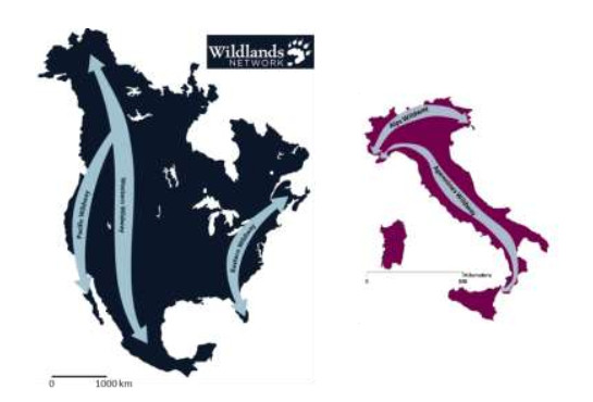
    [63] Gambino R (2003) APE, Appennino Parco d'Europa. Ministero dell'Ambiente e della Tutela del Territorio, Alinea Firenze. 240.
    [64] Gambino R, Romano B (2004) Territorial strategies and environmental continuity in mountain systems, the case of the Apennines (Italy), Managing Mountain Protected Areas: challenges and responses for the 21st Century, IUCN, Andromeda, 66-77.
    [65] Saura S, Santini L, Rondinini C (2015) Connectivity of the global network of protected areas. Biod Res 22: 199-211.
    [66] Saura S, Bertzky B, Bastin L, et al. (2018) Protected area connectivity: Shortfalls in global targets and country-level priorities. Biol Conserv 219: 53-67.
    [67] Saura S, Bertzky B, Bastin L, et al. (2019) Global trends in protected area connectivity from 2010 to 2018. Biol Conserv 238: 108183.
    [68] Thrush, SF, Hewitt, JE, Lohrer, et al. (2013) When small changes matter: the role of cross‐scale interactions between habitat and ecological connectivity in recovery. Ecol Appl 23: 226-238.
    [69] La Point S, Balkenhol N, Hale J, et al. (2015) Ecological connectivity research in urban areas. Funct Ecol 29: 868-878.
    [70] Rosengarten F (2009) The contemporary relevance of Gramsci's views on Italy's "Southern question". Perspectives on Gramsci, Politics, culture and social theory, Routledge, UK, 134-144.
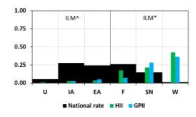
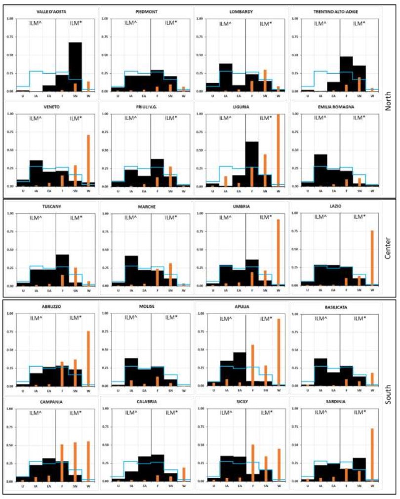
    [71] Romano B, Fiorini L, Di Dato C, et al. (2020) Latitudinal Gradient in Urban Pressure and Socio Environmental Quality: The "Peninsula Effect" in Italy. Land 9: 126.
    [72] Forman RTT, Sperling D, Bissonette JA, et al. (2002) Road Ecology: Science and Solutions. Island Press, 479.
    [73] Jaeger AG, Schwarz-von Raumer HG, Esswein H, et al. (2007) Time series of landscape fragmentation caused by transportation infrastructure and urban development: a case study from Baden-Württemberg, Germany. Ecol Soc 12: 22.
    [74] Karlson M, Mörtberg U, Balfors B (2014) Road ecology in environmental impact assessment. Environ Impact Assess 48: 10-19.
    [75] Zurlini G, Amadio V, Rossi O (1999) A Landscape Approach to Biodiversity and Biological Health Planning: The Map of Italian. Ecosyst Health 5: 294-311
    [76] Maiorano L, Falcucci A, Boitani L (2006) Gap analysis of terrestrial vertebrates in Italy: Priorities for conservation planning in a human dominated landscape. Biol Conserv 133: 455-473.
    [77] Rondinini C, Boitani L (2007) Systematic Conservation Planning and the Cost of Tackling Conservation Conflicts with Large Carnivores in Italy. Conserv Biol 21: 1455-1462.
    [78] Peruzzi L, Conti F, Bartolucci F (2014) An inventory of vascular plants endemic to Italy. Phytotaxa 168: 1-75.
    [79] Baldwin RF, Reed SE, McRae BH, et al. (2012) Connectivity Restoration in Large Landscapes: Modeling Landscape Condition and Ecological Flows. Ecol Restor 30: 274-279.
    [80] Foster ML, Humphrey SR (1995) Use of Highway Underpasses by Florida Panthers and Other Wildlife. Wildlife Soc B 23: 95-100.
    [81] Rosillon F (2004) Valley landscape management: the context of the "river contract" in the Semois Valley (Belgium). Landscape Res 29: 413-422.
    [82] Brun A (2010) Les contrats de rivière en France: un outil de gestion concertée de la ressource en local. La Découverte 498.
    [83] Peng J, Zhao H, Liu Y (2017) Urban ecological corridors construction: A review. Acta Ecologica Sinica 37: 23-30.
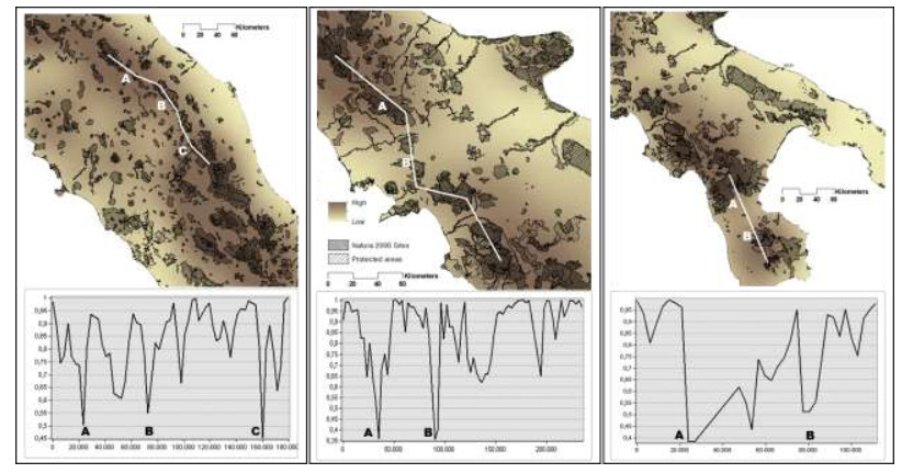
    [84] Marucci A, Zullo F, Fiorini L, et al. (2019) The role of infrastructural barriers and gaps on Natura 2000 functionality in Italy A case study on Umbria region. Rendiconti Lincei 30: 223-235.
  • This article has been cited by:

    1. Maria Silvia Binetti, Claudia Campanale, Vito Felice Uricchio, Carmine Massarelli, In-Depth Monitoring of Anthropic Activities in the Puglia Region: What Is the Acceptable Compromise between Economic Activities and Environmental Protection?, 2023, 15, 2071-1050, 8875, 10.3390/su15118875
  • Reader Comments
  • © 2020 the Author(s), licensee AIMS Press. This is an open access article distributed under the terms of the Creative Commons Attribution License (http://creativecommons.org/licenses/by/4.0)
通讯作者: 陈斌, bchen63@163.com
  • 1. 

    沈阳化工大学材料科学与工程学院 沈阳 110142

  1. 本站搜索
  2. 百度学术搜索
  3. 万方数据库搜索
  4. CNKI搜索

Metrics

Article views(4275) PDF downloads(6) Cited by(1)

Figures and Tables

Figures(8)  /  Tables(3)

/

DownLoad:  Full-Size Img  PowerPoint
Return
Return

Catalog