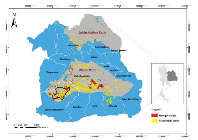
The research purpose is to assess and delineate groundwater potential zones (GWPZs) in the saline soil area in the districts of Non-Thai, Non-Sung, Non-Daeng, Khong, and Kham Sakae Saeng, Nakhon Ratchasima province, Thailand, using remote sensing (RS), geographical information system (GIS), and analytical hierarchy process (AHP) techniques. The GWPZs were created by combining multiple influencing factors such as slope, landforms, annual rainfall, soil texture class, drainage density, geology, hydrogeological unit, land use/land cover, groundwater potential, and normalized difference vegetation index of the study area. The AHP technique was used to determine the weights of various thematic layers to identify the groundwater potential zone. The weights of the thematic layers in descending order consisted of hydrogeological unit (17.61%), geology (17.10%), groundwater potential (12.09%), soil texture class (12.09%), drainage density (8.55%), landforms (8.46%), land use/land cover (6.05%), slope (6.01%), annual rainfall (6.01%), and normalized difference vegetation index (6.01%), respectively. The acceptable consistency ratio (CR) is used to evaluate the reliability of AHP techniques, and which coefficient of determination (R2) of 0.7131 was used to validate the salinity data of 17 groundwater wells. The overall weightage of the AHP technique assessment was classified into 5 categories of the GWPZs including very high potential, high potential, moderate potential, poor potential, and very poor potential. The mostly groundwater quality distribution represented a moderate potential of about 1,101 km2 (46.01%) to a poor potential of about 1,114 km2 (46.57%) from the 2,390 km2 of the study area located throughout the study area especially Kham Sakae Saeng, Non-Thai, and Non-Sung districts.
Citation: Watcharin Phoemphon, Bantita Terakulsatit. Assessment of groundwater potential zones and mapping using GIS/RS techniques and analytic hierarchy process: A case study on saline soil area, Nakhon Ratchasima, Thailand[J]. AIMS Geosciences, 2023, 9(1): 49-67. doi: 10.3934/geosci.2023004
The research purpose is to assess and delineate groundwater potential zones (GWPZs) in the saline soil area in the districts of Non-Thai, Non-Sung, Non-Daeng, Khong, and Kham Sakae Saeng, Nakhon Ratchasima province, Thailand, using remote sensing (RS), geographical information system (GIS), and analytical hierarchy process (AHP) techniques. The GWPZs were created by combining multiple influencing factors such as slope, landforms, annual rainfall, soil texture class, drainage density, geology, hydrogeological unit, land use/land cover, groundwater potential, and normalized difference vegetation index of the study area. The AHP technique was used to determine the weights of various thematic layers to identify the groundwater potential zone. The weights of the thematic layers in descending order consisted of hydrogeological unit (17.61%), geology (17.10%), groundwater potential (12.09%), soil texture class (12.09%), drainage density (8.55%), landforms (8.46%), land use/land cover (6.05%), slope (6.01%), annual rainfall (6.01%), and normalized difference vegetation index (6.01%), respectively. The acceptable consistency ratio (CR) is used to evaluate the reliability of AHP techniques, and which coefficient of determination (R2) of 0.7131 was used to validate the salinity data of 17 groundwater wells. The overall weightage of the AHP technique assessment was classified into 5 categories of the GWPZs including very high potential, high potential, moderate potential, poor potential, and very poor potential. The mostly groundwater quality distribution represented a moderate potential of about 1,101 km2 (46.01%) to a poor potential of about 1,114 km2 (46.57%) from the 2,390 km2 of the study area located throughout the study area especially Kham Sakae Saeng, Non-Thai, and Non-Sung districts.

| [1] |
El Tabakh M, Utha-Aroon C, Schreiber BC (1999) Sedimentology of the Cretaceous Maha Sarakham evaporites in the Khorat Plateau of northeastern Thailand. Sediment Geol 123: 31–62. https://doi.org/10.1016/S0037-0738(98)00083-9 doi: 10.1016/S0037-0738(98)00083-9

|
| [2] |
Davis S, Whittemore D, Fabryka-Martin J (1998) Uses of Chloride/Bromide Ratios in Studies of Potable Water. Ground Water 36: 338–350. https://doi.org/10.1111/j.1745-6584.1998.tb01099.x doi: 10.1111/j.1745-6584.1998.tb01099.x
|
| [3] | Wannakomol A (2012) Mapping of groundwater using an electrical survey in the vicinity of Nakhon Ratchasima province. Suranaree University of Technology Intellectual Repository, Nakhon Ratchasima, Thailand. Available from: http://sutir.sut.ac.th:8080/jspui/handle/123456789/4001 |
| [4] | DMR (2015) Saline Soil Area Development in the Northeast: Geological approaches. Division of Mineral Resources Conservation and Management. Available from: https://www.dmr.go.th/wp-content/uploads/2022/10/article_20161011102857-1.pdf |
| [5] | Tatong T (2004) Hydrogeology of the Khorat Greater City Area and Investigation of the Causes and Effects of Groundwater and Soil Salinization. Bangkok: Department of Mineral Resources. Available from: http://library.dmr.go.th/elib/cgi-bin/opacexe.exe?op=mmvw&db=Main&sid=undefined&skin=u&usid=undefined&mmid=628&bid=11978 |
| [6] | Ndatuwong L, Yadav G (2014) Morphometric Analysis to Infer the Hydrogeological Behaviour in Part of Sonebhadra District, Uttar Pradesh, India, Using Remote Sensing and GIS Technique. Int J Remote Sens GIS 3: 1–7. |
| [7] |
Ntona MM, Busico G, Mastrocicco M, et al. (2022) Modeling groundwater and surface water interaction: An overview of current status and future challenges. Sci Total Environ 846: 157355. https://doi.org/10.1016/j.scitotenv.2022.157355 doi: 10.1016/j.scitotenv.2022.157355
|
| [8] | Jha MK, Peiffer S (2006) Applications of remote sensing and GIS technologies in groundwater hydrology: past, present, and future, BayCEER Bayreuth. |
| [9] |
Vittala SS, Govindaiah S, Gowda HH (2005) Evaluation of groundwater potential zones in the sub-watersheds of north pennar river basin around Pavagada, Karnataka, India using remote sensing and GIS techniques. J Indian Soc Remote Sens 33: 483. https://doi.org/10.1007/BF02990733 doi: 10.1007/BF02990733
|
| [10] |
Duguma TA, Duguma GA (2022) Assessment of Groundwater Potential Zones of Upper Blue Nile River Basin Using Multi-Influencing Factors under GIS and RS Environment: A Case Study on Guder Watersheds, Abay Basin, Oromia Region, Ethiopia. Geofluids 2022: 26. https://doi.org/10.1155/2022/1172039 doi: 10.1155/2022/1172039
|
| [11] |
Sinanuwong S, Takaya Y (1974) Distribution of Saline Soils in the Khorat Basin of Thailand. Southeast Asian Stud 12: 365–382. https://doi.org/10.20495/tak.12.3_365 doi: 10.20495/tak.12.3_365
|
| [12] | Thongwat W (2018) Relationship between soil salinity and chloride content in groundwater in saline soil areas of Nakhon Ratchasima province, Suranaree University of Technology Intellectual Repository. |
| [13] | NASA, METI, AIST, et al. (2019) ASTER Global Digital Elevation Model V003 [Data set]. NASA EOSDIS Land Processes DAAC. Available from: https://search.earthdata.nasa.gov/search?q=%20C1711961296-LPCLOUD |
| [14] |
Theobald DM, Harrison-Atlas D, Monahan WB, et al. (2015) Ecologically-Relevant Maps of Landforms and Physiographic Diversity for Climate Adaptation Planning. PLOS ONE 10: e0143619. https://doi.org/10.1371/journal.pone.0143619 doi: 10.1371/journal.pone.0143619
|
| [15] | Hengl T (2018) Soil texture classes (USDA system) for 6 soil depths (0, 10, 30, 60,100 and 200 cm) at 250 m. OpenAIRE. |
| [16] |
Selvam S, Magesh NS, Chidambaram S, et al. (2015) A GIS-based identification of groundwater recharge potential zones using RS and IF technique: a case study in Ottapidaram taluk, Tuticorin district, Tamil Nadu. Environ Earth Sci 73: 3785–3799. https://doi.org/10.1007/s12665-014-3664-0 doi: 10.1007/s12665-014-3664-0
|
| [17] | Manjare BS (2014) Identification of groundwater prospecting zones using Remote Sensing and GIS techniques in upper Vena river watersheds Nagpur district, Maharashtra, India. 15th Esri India User Conference, 1–14. |
| [18] | Sikakwe G, Ntekim E, Obi D, et al. (2015) Geohydrological study of weathered basement aquifers in Oban Massif and environs Southeastern Nigeria: using Remote Sensing and Geographic Information System Techniques. Geophysics 3: 321–990. |
| [19] | Malik S, Rajeshwari D (2011) Delineation of groundwater potential zones in Mewat District. Int J Geomatics Geosci 2: 278–281. |
| [20] | Karanth KR, Seshu babu K (1987) Identification of major lineaments on satellite imagery and aerial photographs for the delineation for possible potential groundwater zones in Penukonda and Dharmavaram taluks of Anantapur district. Proceedings of the Joint Indo-US Workshop on Remote Sensing of Water Resources, National Remote Sensing Agency (NRSA), Hyderabad, India, 188–197 |
| [21] |
Kumar T, Gautam AK, Kumar T (2014) Appraising the accuracy of GIS-based Multi-criteria decision making technique for delineation of Groundwater potential zones. Water Resour Manage 28: 4449–4466. https://doi.org/10.1007/s11269-014-0663-6 doi: 10.1007/s11269-014-0663-6
|
| [22] | Radhakrishnan D, Ramamoorthy P (2014) Delineation of groundwater recharge potential zones in Mailam Block, Villupuram district, Using GIS. Int J Water Res 2: 71–75. |
| [23] |
Magesh NS, Chandrasekar N, Soundranayagam JP (2012) Delineation of groundwater potential zones in Theni district, Tamil Nadu, using remote sensing, GIS and MIF techniques. Geosci Front 3: 189–196. https://doi.org/10.1016/j.gsf.2011.10.007 doi: 10.1016/j.gsf.2011.10.007
|
| [24] | Hutti B, Nijagunappa R (2011) Identification of Groundwater Potential Zone using Geoinformatics in Ghataprabha basin, North Karnataka, India. Int J Geomatics Geosci 2: 91–109. |
| [25] |
Shaban A, Khawlie M, Abdallah C (2006) Use of remote sensing and GIS to determine recharge potential zones: the case of Occidental Lebanon. Hydrogeol J 14: 433–443. https://doi.org/10.1007/s10040-005-0437-6 doi: 10.1007/s10040-005-0437-6
|
| [26] |
Lohman AHM, Mentink GM (1972) Some cortical connections of the tegu lizard (Tupinambis teguixin). Brain Res 45: 325–344. https://doi.org/10.1016/0006-8993(72)90466-0 doi: 10.1016/0006-8993(72)90466-0
|
| [27] |
Guru B, Seshan K, Bera S (2017) Frequency ratio model for groundwater potential mapping and its sustainable management in cold desert, India. J King Saud Univ Sci 29: 333–347. https://doi.org/10.1016/j.jksus.2016.08.003 doi: 10.1016/j.jksus.2016.08.003
|
| [28] |
Ahmad I, Dar MA, Teka AH, et al. (2020) GIS and fuzzy logic techniques-based demarcation of groundwater potential zones: A case study from Jemma River basin, Ethiopia. J Afr Earth Sci 169: 103860. https://doi.org/10.1016/j.jafrearsci.2020.103860 doi: 10.1016/j.jafrearsci.2020.103860
|
| [29] |
Lu M, Xu Z, Yang ZL, et al. (2021) A Comprehensive Review of Specific Yield in Land Surface and Groundwater Studies. J Adv Model Earth Syst 13: e2020MS002270. https://doi.org/10.1029/2020MS002270 doi: 10.1029/2020MS002270
|
| [30] |
Sarath Prasanth SV, Magesh NS, Jitheshlal KV, et al. (2012) Evaluation of groundwater quality and its suitability for drinking and agricultural use in the coastal stretch of Alappuzha District, Kerala, India. Appl Water Sci 2: 165–175. https://doi.org/10.1007/s13201-012-0042-5 doi: 10.1007/s13201-012-0042-5
|
| [31] |
Bhanja SN, Malakar P, Mukherjee A, et al. (2019) Using Satellite-Based Vegetation Cover as Indicator of Groundwater Storage in Natural Vegetation Areas. Geophys Res Lett 46: 8082–8092. https://doi.org/10.1029/2019GL083015 doi: 10.1029/2019GL083015
|
| [32] |
Saaty RW (1987) The analytic hierarchy process—what it is and how it is used. Math Modell 9: 161–176. https://doi.org/10.1016/0270-0255(87)90473-8 doi: 10.1016/0270-0255(87)90473-8
|
| [33] | Goepel K (2013) Implementing the Analytic Hierarchy Process as a Standard Method for Multi-Criteria Decision Making in Corporate Enterprises—a New AHP Excel Template with Multiple Inputs. Proceedings of the international symposium on the analytic hierarchy process, Malaysia. 1–10. |
| [34] |
Razzagh S, Sadeghfam S, Nadiri AA, et al. (2022) Formulation of Shannon entropy model averaging for groundwater level prediction using artificial intelligence models. Int J Environ Sci Technol 19: 6203–6220. https://doi.org/10.1007/s13762-021-03793-2 doi: 10.1007/s13762-021-03793-2
|


Figures(7) / Tables(5)

Watcharin Phoemphon, Bantita Terakulsatit. Assessment of groundwater potential zones and mapping using GIS/RS techniques and analytic hierarchy process: A case study on saline soil area, Nakhon Ratchasima, Thailand[J]. AIMS Geosciences, 2023, 9(1): 49-67. doi: 10.3934/geosci.2023004


 DownLoad: