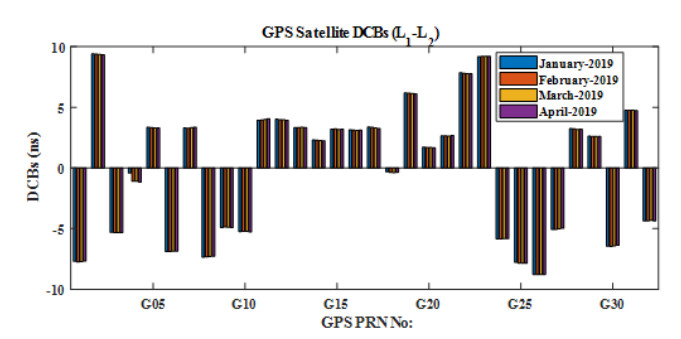
Multi Global Navigation Satellite System (GNSS) plays an essential role in navigation and geodesy fields for positioning, Navigation, and Timing (PNT) services. The predominant challenge of multi-GNSS is hardware bias errors such as Differential code Bias (DCB) and Inter System Biases (ISB). The estimation of DCB and ISB are essential for analyzing the GNSS system performance to improve the positional accuracy. Navigation with the Indian Constellation (NavIC) system consists of the entire constellation of seven Geo-Stationary satellites to cater to Position Navigation Time (PNT) services over India and adjacent areas. In this paper, the relation between DCB and ISB of Global Positioning System (GPS) and NavIC systems is investigated using two ground-based NovAtel GPS and three Accords NavIC Receivers data (January to April 2019) at Koneru Lakshamaiah Education Foundation (K.L. Deemed to University), Guntur, India (16.47°N, 80.61°E). The correlation results indicate that NavIC GSO satellites are more stable than GEO satellites from DCB and ISB analysis due to low elevation angles and multipath effects. A systematic bias error is observed between NavIC and GPS satellite systems from ISB and DCB results. The current research work outcome would be beneficial for modeling GNSS ionospheric Total Electron Content (TEC) for high precision multi-constellation and multi-frequency GNSS systems.
Citation: K. Siva Krishna, D. Venkata Ratnam. Analysis of differential code biases and inter-system biases for GPS and NavIC satellite constellations[J]. AIMS Electronics and Electrical Engineering, 2021, 5(3): 194-205. doi: 10.3934/electreng.2021011
Multi Global Navigation Satellite System (GNSS) plays an essential role in navigation and geodesy fields for positioning, Navigation, and Timing (PNT) services. The predominant challenge of multi-GNSS is hardware bias errors such as Differential code Bias (DCB) and Inter System Biases (ISB). The estimation of DCB and ISB are essential for analyzing the GNSS system performance to improve the positional accuracy. Navigation with the Indian Constellation (NavIC) system consists of the entire constellation of seven Geo-Stationary satellites to cater to Position Navigation Time (PNT) services over India and adjacent areas. In this paper, the relation between DCB and ISB of Global Positioning System (GPS) and NavIC systems is investigated using two ground-based NovAtel GPS and three Accords NavIC Receivers data (January to April 2019) at Koneru Lakshamaiah Education Foundation (K.L. Deemed to University), Guntur, India (16.47°N, 80.61°E). The correlation results indicate that NavIC GSO satellites are more stable than GEO satellites from DCB and ISB analysis due to low elevation angles and multipath effects. A systematic bias error is observed between NavIC and GPS satellite systems from ISB and DCB results. The current research work outcome would be beneficial for modeling GNSS ionospheric Total Electron Content (TEC) for high precision multi-constellation and multi-frequency GNSS systems.

| [1] | ISRO (2014) Indian regional navigation satellite system: signal in space ICD for symbolizeard positioning service, Version 1.0. ISRO Satellite Centre. |
| [2] |
Zaminpardaz S, Teunissen PJ, Nadarajah N (2016) IRNSS symbolize-alone positioning: first results in Australia. J Spat Sci 61: 5-27. doi: 10.1080/14498596.2016.1142398

|
| [3] |
Montenbruck O, Steigenberger P, Prange L, et al. (2017) The Multi-GNSS Experiment (MGEX) of the International GNSS Service (IGS)-achievements, prospects and challenges. Adv Space Res 59: 1671-1697. doi: 10.1016/j.asr.2017.01.011
|
| [4] | Arikan F, Nayir H, Sezen U, et al. (2008) Estimation of single station interfrequency receiver bias using GPS-TEC. Radio Sci 43. |
| [5] |
Odijk D, Teunissen PJ (2013) Characterization of between-receiver GPS-Galileo inter-system biases and their effect on mixed ambiguity resolution. GPS solutions 17: 521-533. doi: 10.1007/s10291-012-0298-0
|
| [6] |
Li X, Ge M, Dai X, et al. (2015) Accuracy and reliability of multi-GNSS real-time precise positioning: GPS, GLONASS, BeiDou, and Galileo. J Geodesy 89: 607-635. doi: 10.1007/s00190-015-0802-8
|
| [7] |
Hong J, Tu R, Gao Y, et al. (2019) Characteristics of inter-system biases in Multi-GNSS with precise point positioning. Adv Space Res 63: 3777-3794. doi: 10.1016/j.asr.2019.02.037
|
| [8] |
Zeng A, Yang Y, Ming F, et al. (2017). BDS-GPS inter-system bias of code observation and its preliminary analysis. GPS Solutions 21: 1573-1581. doi: 10.1007/s10291-017-0636-3
|
| [9] |
Li X, Xie W, Huang J, et al. (2019) Estimation and analysis of differential code biases for BDS3/BDS2 using iGMAS and MGEX observations. J Geodesy 93: 419-435. doi: 10.1007/s00190-018-1170-y
|
| [10] |
Li Z, Yuan Y, Fan L, et al. (2013) Determination of the differential code bias for current BDS satellites. IEEE T Geosci Remote 52: 3968-3979. doi: 10.1109/TGRS.2013.2278545
|
| [11] | Zhang W, Cannon ME, Julien O, et al. (2003) Investigation of combined GPS/GALILEO cascading ambiguity resolution schemes. In Proceedings of ION, 2599-2610. |
| [12] | GPStation-6 User Manual Rev-2, 2012. Available from: https://hexagondownloads.blob.core.windows.net/public/Novatel/assets/Documents/Manuals/om-20000132/om-20000132.pdf |
| [13] |
Ciraolo L, Azpilicueta F, Brunini C, et al. (2007) Calibration errors on experimental slant total electron content (TEC) determined with GPS. J Geodesy 81: 111-120. doi: 10.1007/s00190-006-0093-1
|
| [14] |
Krishna KS, Ratnam DV (2020) Determination of NavIC differential code biases using GPS and NavIC observations. Geodesy and Geodynamics 11: 97-105. doi: 10.1016/j.geog.2020.01.001
|
| [15] |
Maheshwari M, Nirmala S, Kavitha S, et al. (2019) Kalman filter based estimation of differential hardware biases with triangular interpolation technique for IRNSS. Adv Space Res 63: 1051-1064. doi: 10.1016/j.asr.2018.09.031
|
| [16] | Lingwal Y, Kumar R, Singh FB, et al. (2019) Estimation of Differential Code Bias of IRNSS Satellites using Global Ionosphere Map. In INCOSE International Symposium 29: 408-418. |


Figures(7) / Tables(1)

K. Siva Krishna, D. Venkata Ratnam. Analysis of differential code biases and inter-system biases for GPS and NavIC satellite constellations[J]. AIMS Electronics and Electrical Engineering, 2021, 5(3): 194-205. doi: 10.3934/electreng.2021011


 DownLoad: